TopoQuest Logo
Do you find TopoQuest useful?
Help keep TopoQuest running and adding new maps/features by donating!
Bitcoin:  19c7KJd3qBynnjoSw5npx9KScwjBe4ifkT
Litecoin:  LXs6TkuXGGXo1vDsWCkWVdjQX94eUKd6ui
Home View Maps Find Maps Find Places Resources & Links


Skinner Canyon, Nevada Topographic Map

USGS Map Title: Skinner Canyon, NV
USGS Map MRC: 39114F1
DRG (GeoTIFF) Download: o39114f1.tif


Neighboring USGS Topographic Map Quads:


  Tippett Canyon, NV  
39114G2
 

  Weaver Canyon, NV  
39114G1
 

  Ibapah Peak, UT  
39113G8
 

  Blue Mass Canyon, NV  
39114F2
 

  Skinner Canyon, NV  
39114F1
 

  Partoun, UT  
39113F8
 

  Government Peak, NV  
39114E2
 

  Tin Springs Mountain, NV  
39114E1
 

  Trout Creek SW, UT  
39113E8


Map MRC Location:

N40°
W115°
N40°
W114°
H8 H7 H6 H5 H4 H3 H2 H1
G8 G7 G6 G5 G4 G3 G2 G1
F8 F7 F6 F5 F4 F3 F2 F1
E8 E7 E6 E5 E4 E3 E2 E1
D8 D7 D6 D5 D4 D3 D2 D1
C8 C7 C6 C5 C4 C3 C2 C1
B8 B7 B6 B5 B4 B3 B2 B1
A8 A7 A6 A5 A4 A3 A2 A1
N39°
W115°
N39°
W114°

Skinner Canyon, NV USGS 1:24K Topographic Map Preview:
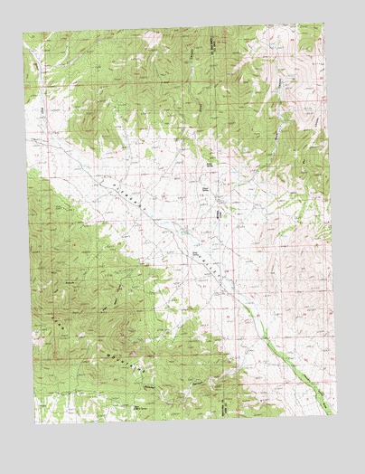
Skinner Canyon, NV USGS Topographic Map
Click on map above to begin viewing in our Map Viewer.

This topographic map contains these locations and features:
Feature Name Type Latitude Longitude GNIS ID View Map
Cane SpringSpringN39.6770°W114.0590°849064View Map
Cliff CanyonValleyN39.7386°W114.1172°849039View Map
Dry CanyonValleyN39.6499°W114.0283°1435451View Map
East Side SpringSpringN39.6611°W114.0775°850892View Map
Essex CanyonValleyN39.7099°W114.0625°853767View Map
Gravel SpringSpringN39.6982°W114.0537°849061View Map
Gravel WashStreamN39.7144°W114.1106°849067View Map
Indian SpringSpringN39.7060°W114.0516°849060View Map
Mallory CanyonValleyN39.7069°W114.1231°849113View Map
Parker (historical)Populated PlaceN39.7027°W114.1008°857508View Map
Parker Post Office (historical)Post OfficeN39.7027°W114.1008°864846View Map
Pete Neece CanyonValleyN39.6727°W114.0831°849063View Map
Pleasant ValleyValleyN39.6409°W114.0184°842887View Map
Pleasant Valley (historical)Populated PlaceN39.6833°W114.0675°857507View Map
Pleasant Valley Post Office (historical)Post OfficeN39.6833°W114.0675°864843View Map
Pole CanyonValleyN39.6802°W114.0961°849062View Map
Skinner CanyonValleyN39.6413°W114.0400°849065View Map
Upper Sulphur SpringSpringN39.6298°W114.0851°849066View Map
Uvada (historical)Populated PlaceN39.6711°W114.0506°851820View Map
Uvada Post Office (historical)Post OfficeN39.6711°W114.0506°864327View Map
Uvada RanchLocaleN39.6855°W114.0644°849725View Map
Uvada School (historical)SchoolN39.6852°W114.0656°858304View Map
Water CanyonValleyN39.7011°W114.0328°1436593View Map

Note: Coordinates in the location and feature list above are referenced to NAD83 datum.


Copyright (C) 2008-2024 Ryan Niemi / Sunset Dynamics ... All Rights Reserved