TopoQuest Logo
Do you find TopoQuest useful?
Help keep TopoQuest running and adding new maps/features by donating!
Bitcoin:  19c7KJd3qBynnjoSw5npx9KScwjBe4ifkT
Litecoin:  LXs6TkuXGGXo1vDsWCkWVdjQX94eUKd6ui
Home View Maps Find Maps Find Places Resources & Links


Slickville, Pennsylvania Topographic Map

USGS Map Title: Slickville, PA
USGS Map MRC: 40079D5
DRG (GeoTIFF) Download: o40079d5.tif


Neighboring USGS Topographic Map Quads:


  New Kensington East, PA  
40079E6
 

  Vandergrift, PA  
40079E5
 

  Avonmore, PA  
40079E4
 

  Murrysville, PA  
40079D6
 

  Slickville, PA  
40079D5
 

  Saltsburg, PA  
40079D4
 

  Irwin, PA  
40079C6
 

  Greensburg, PA  
40079C5
 

  Latrobe, PA  
40079C4


Map MRC Location:

N41°
W80°
N41°
W79°
H8 H7 H6 H5 H4 H3 H2 H1
G8 G7 G6 G5 G4 G3 G2 G1
F8 F7 F6 F5 F4 F3 F2 F1
E8 E7 E6 E5 E4 E3 E2 E1
D8 D7 D6 D5 D4 D3 D2 D1
C8 C7 C6 C5 C4 C3 C2 C1
B8 B7 B6 B5 B4 B3 B2 B1
A8 A7 A6 A5 A4 A3 A2 A1
N40°
W80°
N40°
W79°

Slickville, PA USGS 1:24K Topographic Map Preview:
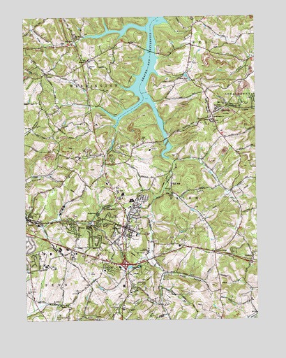
Slickville, PA USGS Topographic Map
Click on map above to begin viewing in our Map Viewer.

This topographic map contains these locations and features:
Feature Name Type Latitude Longitude GNIS ID View Map
Armitage and Artman Delmont Airport (historical)AirportN40.4584°W79.5859°1213777View Map
Beaver Run ReservoirReservoirN40.4835°W79.5594°1169048View Map
Boggs HollowValleyN40.3999°W79.5570°1213501View Map
BoquetPopulated PlaceN40.3815°W79.6023°1170007View Map
Borough of DelmontCivilN40.4144°W79.5729°1215695View Map
Borough of ExportCivilN40.4169°W79.6231°1215699View Map
Brook Shore LakesReservoirN40.4757°W79.5371°1170319View Map
Clover Leaf LakeLakeN40.3969°W79.5687°1172030View Map
Cloverleaf Golf CourseLocaleN40.3934°W79.5789°1206163View Map
CongruityPopulated PlaceN40.3984°W79.5037°1172330View Map
Cornerstone Ministries ChurchChurchN40.4062°W79.6081°1213505View Map
Crooked RunStreamN40.3884°W79.5517°1213502View Map
DelmontPopulated PlaceN40.4131°W79.5703°1173139View Map
Delmont Borough Police DepartmentBuildingN40.4104°W79.5718°2780189View Map
Delmont Compressor StationBuildingN40.3842°W79.5478°1213504View Map
Delmont Post OfficePost OfficeN40.4115°W79.5718°2431871View Map
Delmont Public LibraryBuildingN40.4099°W79.5722°2429929View Map
Delmont Volunteer Fire DepartmentBuildingN40.4083°W79.5739°2644983View Map
DunningtownPopulated PlaceN40.4212°W79.5823°1173627View Map
East View CemeteryCemeteryN40.4128°W79.5642°1173897View Map
East View CemeteryCemeteryN40.4128°W79.5656°1213500View Map
Elrico ParkParkN40.4640°W79.5062°1213499View Map
Elrico SchoolSchoolN40.4637°W79.5064°1174184View Map
Five PointsPopulated PlaceN40.4031°W79.5228°1174862View Map
Greensburg Jeannette Regional AirportAirportN40.3780°W79.6085°1193961View Map
Holy Ghost ChurchChurchN40.4620°W79.5195°1177274View Map
J Arthur Duff Elementary SchoolSchoolN40.4184°W79.6248°1211571View Map
Life Flight 6 Greensburg - Jeannette Regional AirportBuildingN40.3788°W79.6074°2719579View Map
MamontPopulated PlaceN40.4820°W79.5903°1180250View Map
Mamont SchoolSchoolN40.4795°W79.5889°1180251View Map
Mutual Aid Ambulance Service DelmontBuildingN40.4105°W79.5736°2719483View Map
Oakford Pumping StationLocaleN40.4026°W79.5592°1182818View Map
Park View ChurchChurchN40.4637°W79.5159°1183308View Map
Poke RunStreamN40.4920°W79.5887°1184184View Map
Poke RunPopulated PlaceN40.4903°W79.5967°1204434View Map
Poke Run ChurchChurchN40.4920°W79.5964°1184185View Map
Porters RunStreamN40.4403°W79.5437°1184305View Map
RingertownPopulated PlaceN40.4184°W79.5853°1185091View Map
Saint Johns ChurchChurchN40.3820°W79.6098°1186110View Map
Saint Johns ChurchChurchN40.4215°W79.5673°1186112View Map
Saint Sylvester ChurchChurchN40.4584°W79.5220°1186733View Map
Salem Crossroads Day Care CenterBuildingN40.4099°W79.5722°2430728View Map
Sleepy HollowValleyN40.3814°W79.5521°1213503View Map
SlickvillePopulated PlaceN40.4598°W79.5231°1187805View Map
Slickville Census Designated PlaceCensusN40.4621°W79.5184°2390306View Map
Slickville Post OfficePost OfficeN40.4605°W79.5211°2779830View Map
Slickville Volunteer Fire Department Station 59 Salem Township Company 1BuildingN40.4604°W79.5207°2645555View Map
Sloan Elementary SchoolSchoolN40.4576°W79.5223°1210750View Map
Thorn RunStreamN40.4542°W79.5759°1213497View Map
Tombers LakeLakeN40.3992°W79.5637°1189633View Map
Township of SalemCivilN40.4071°W79.5141°1217256View Map
Trees MillsPopulated PlaceN40.4309°W79.5456°1189741View Map
Trinity ChurchChurchN40.4126°W79.5689°1189787View Map
Twin Valley Memorial Park CemeteryCemeteryN40.4212°W79.5656°1190019View Map
Westmoreland County Food BankBuildingN40.3967°W79.5816°2430894View Map
White ValleyPopulated PlaceN40.4159°W79.5984°1191319View Map
White Valley Volunteer Fire DepartmentBuildingN40.4155°W79.6031°2645013View Map
WiesterPopulated PlaceN40.4767°W79.6148°1211957View Map
William Penn Day Care and Learning CenterBuildingN40.3980°W79.6026°2430913View Map
Woodlawn CemeteryCemeteryN40.3867°W79.6245°1173152View Map

Note: Coordinates in the location and feature list above are referenced to NAD83 datum.


Copyright (C) 2008-2025 Ryan Niemi / Sunset Dynamics ... All Rights Reserved