TopoQuest Logo
Do you find TopoQuest useful?
Help keep TopoQuest running and adding new maps/features by donating!
Bitcoin:  19c7KJd3qBynnjoSw5npx9KScwjBe4ifkT
Litecoin:  LXs6TkuXGGXo1vDsWCkWVdjQX94eUKd6ui
Home View Maps Find Maps Find Places Resources & Links


Slippery Rock, Pennsylvania Topographic Map

USGS Map Title: Slippery Rock, PA
USGS Map MRC: 41080A1
DRG (GeoTIFF) Download: o41080a1.tif


Neighboring USGS Topographic Map Quads:


  Mercer, PA  
41080B2
 

  Grove City, PA  
41080B1
 

  Barkeyville, PA  
41079B8
 

  Harlansburg, PA  
41080A2
 

  Slippery Rock, PA  
41080A1
 

  West Sunbury, PA  
41079A8
 

  Portersville, PA  
40080H2
 

  Prospect, PA  
40080H1
 

  Mount Chestnut, PA  
40079H8


Map MRC Location:

N42°
W81°
N42°
W80°
H8 H7 H6 H5 H4 H3 H2 H1
G8 G7 G6 G5 G4 G3 G2 G1
F8 F7 F6 F5 F4 F3 F2 F1
E8 E7 E6 E5 E4 E3 E2 E1
D8 D7 D6 D5 D4 D3 D2 D1
C8 C7 C6 C5 C4 C3 C2 C1
B8 B7 B6 B5 B4 B3 B2 B1
A8 A7 A6 A5 A4 A3 A2 A1
N41°
W81°
N41°
W80°

Slippery Rock, PA USGS 1:24K Topographic Map Preview:
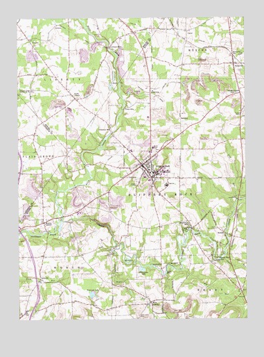
Slippery Rock, PA USGS Topographic Map
Click on map above to begin viewing in our Map Viewer.

This topographic map contains these locations and features:
Feature Name Type Latitude Longitude GNIS ID View Map
Adams CornersLocaleN41.0945°W80.0026°1168057View Map
Armco Country ClubLocaleN41.0378°W80.0159°1213127View Map
ArmstrongPopulated PlaceN41.0942°W80.0517°1202987View Map
Bethel ChurchChurchN41.0937°W80.0042°1169399View Map
Big RunStreamN41.0206°W80.0353°1169577View Map
Borough of Slippery RockCivilN41.0695°W80.0579°1215003View Map
Borough of West LibertyCivilN41.0079°W80.0573°1215005View Map
Camp BucocoLocaleN41.0506°W80.0059°1170982View Map
Camp CrestviewLocaleN41.0273°W80.0734°1170999View Map
CarmonaPopulated PlaceN41.1223°W80.1028°1203223View Map
CarterPopulated PlaceN41.1198°W80.0317°1171280View Map
Center SchoolSchoolN41.0028°W80.1212°1171455View Map
Christleys MillsPopulated PlaceN41.0795°W80.0737°1203272View Map
Courtney SchoolSchoolN41.1151°W80.0709°1196860View Map
Courtneys MillsPopulated PlaceN41.1131°W80.0742°1203352View Map
Crocker SchoolSchoolN41.0512°W80.0814°1196856View Map
Crolls MillsPopulated PlaceN41.0206°W80.0439°1203365View Map
Currys MillsPopulated PlaceN41.0881°W80.0639°1203381View Map
Doughertys MillsPopulated PlaceN41.0378°W80.0298°1173419View Map
Flying Acres Airport (historical)AirportN41.0731°W80.0703°1194166View Map
Foltz SchoolSchoolN41.0090°W80.0009°1174936View Map
ForestvillePopulated PlaceN41.1059°W80.0059°1192478View Map
Forestville Post OfficePost OfficeN41.1068°W80.0063°2779608View Map
Glade RunStreamN41.0251°W80.0139°1175662View Map
Harrisville StationLocaleN41.1098°W80.0062°1176593View Map
HeathPopulated PlaceN41.0978°W80.0731°1203767View Map
Hide-Away LakeLakeN41.0209°W80.0572°1176992View Map
Hogue RunStreamN41.0290°W80.0723°1177186View Map
Holliday SchoolSchoolN41.0076°W80.0270°1196854View Map
JacksvillePopulated PlaceN41.0170°W80.1128°1177945View Map
Jennings Environmental Education CenterParkN41.0101°W80.0028°1196852View Map
KeistersPopulated PlaceN41.0359°W80.0117°1178307View Map
Kelly BridgeBridgeN41.0290°W80.0742°1196857View Map
Kelly SchoolSchoolN41.0281°W80.0920°1196858View Map
Kettle HoleBasinN41.0042°W80.0776°1211888View Map
Long RunStreamN41.0498°W80.0042°1192845View Map
McKee SchoolSchoolN41.0756°W80.1220°1196859View Map
Miller SchoolSchoolN41.0709°W80.0351°1196853View Map
Moores CornersPopulated PlaceN41.0403°W80.1106°1181512View Map
North LibertyPopulated PlaceN41.0928°W80.0942°1182605View Map
North Liberty CemeteryCemeteryN41.0878°W80.0989°1182606View Map
Old Stone HouseBuildingN41.0115°W80.0023°1214144View Map
Pittsburgh Presbyterian SchoolSchoolN41.0267°W80.0744°2431508View Map
Ralston SchoolSchoolN41.0403°W80.0462°1196855View Map
RedmondPopulated PlaceN41.0834°W80.0351°1184810View Map
Rock Falls ParkPopulated PlaceN41.0376°W80.0326°1185251View Map
Shamrock Public Golf CourseLocaleN41.0967°W80.0531°1205257View Map
Slippery RockPopulated PlaceN41.0640°W80.0564°1214014View Map
Slippery Rock Area Elementary SchoolSchoolN41.0701°W80.0623°1211447View Map
Slippery Rock Area High SchoolSchoolN41.0556°W80.0431°1211449View Map
Slippery Rock Area Middle SchoolSchoolN41.0576°W80.0420°1211448View Map
Slippery Rock ParkPopulated PlaceN41.0242°W80.0153°1187824View Map
Slippery Rock Police DepartmentBuildingN41.0662°W80.0549°2781064View Map
Slippery Rock Post OfficePost OfficeN41.0606°W80.0531°2779988View Map
Slippery Rock QuarryMineN41.0425°W80.0553°2709870View Map
Slippery Rock UniversitySchoolN41.0615°W80.0512°1210749View Map
Slippery Rock University Census Designated PlaceCensusN41.0647°W80.0419°2633670View Map
Slippery Rock Volunteer Fire Company 33BuildingN41.0630°W80.0575°2644866View Map
Swamp RunStreamN41.1239°W80.0878°1189134View Map
Tamarack LakeLakeN41.0107°W80.0845°1189245View Map
Township of LibertyCivilN41.1123°W80.1011°1216808View Map
Township of Slippery RockCivilN41.0624°W80.0322°1216066View Map
Township of WorthCivilN41.0005°W80.1108°1216088View Map
ValcourtPopulated PlaceN41.1162°W80.1181°1204860View Map
West LibertyPopulated PlaceN41.0070°W80.0526°1190953View Map
West Liberty CemeteryCemeteryN41.0015°W80.0589°1191063View Map
West Liberty EskerRidgeN41.0159°W80.1023°1201320View Map
Wolf CreekStreamN41.0412°W80.1017°1191653View Map
WSRU-FM (Slippery Rock)TowerN41.0642°W80.0467°1200278View Map

Note: Coordinates in the location and feature list above are referenced to NAD83 datum.


Copyright (C) 2008-2025 Ryan Niemi / Sunset Dynamics ... All Rights Reserved