TopoQuest Logo
Do you find TopoQuest useful?
Help keep TopoQuest running and adding new maps/features by donating!
Bitcoin:  19c7KJd3qBynnjoSw5npx9KScwjBe4ifkT
Litecoin:  LXs6TkuXGGXo1vDsWCkWVdjQX94eUKd6ui
Home View Maps Find Maps Find Places Resources & Links


Smith River, California Topographic Map

USGS Map Title: Smith River, CA
USGS Map MRC: 41124H2
DRG (GeoTIFF) Download: o41124h2.tif


Neighboring USGS Topographic Map Quads:


  Brookings, OR  
42124A3
 

  Mount Emily, OR  
42124A2
 

  Fourth of July Creek, OR  
42124A1


  Smith River, CA  
41124H2
 

  High Divide, CA  
41124H1


  Crescent City, CA  
41124G2
 

  Hiouchi, CA  
41124G1


Map MRC Location:

N42°
W125°
N42°
W124°
H8 H7 H6 H5 H4 H3 H2 H1
G8 G7 G6 G5 G4 G3 G2 G1
F8 F7 F6 F5 F4 F3 F2 F1
E8 E7 E6 E5 E4 E3 E2 E1
D8 D7 D6 D5 D4 D3 D2 D1
C8 C7 C6 C5 C4 C3 C2 C1
B8 B7 B6 B5 B4 B3 B2 B1
A8 A7 A6 A5 A4 A3 A2 A1
N41°
W125°
N41°
W124°

Smith River, CA USGS 1:24K Topographic Map Preview:
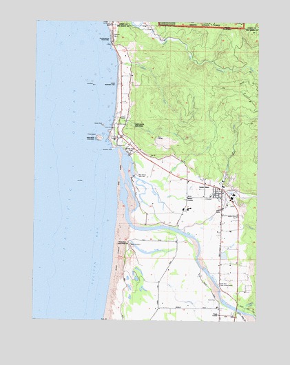
Smith River, CA USGS Topographic Map
Click on map above to begin viewing in our Map Viewer.

This topographic map contains these locations and features:
Feature Name Type Latitude Longitude GNIS ID View Map
Cone RockIslandN41.9734°W124.2195°221447View Map
Crissey Airport (historical)AirportN41.9996°W124.2106°1116480View Map
Delilah CreekStreamN41.9315°W124.1854°222248View Map
Dominie CreekStreamN41.9282°W124.1442°222485View Map
Faith Tabernacle Assembly of God ChurchChurchN41.9268°W124.1492°1682077View Map
Gilbert CreekStreamN41.9793°W124.2059°224162View Map
How - On - Quet Indian CemeteryCemeteryN41.9549°W124.2067°2755367View Map
Hunter RockIslandN41.9562°W124.2131°225789View Map
Hutsinpillar CreekStreamN41.8787°W124.1329°225810View Map
Indian CemeteryCemeteryN41.9548°W124.2070°1657327View Map
Kamph Memorial ParkParkN41.9734°W124.2059°226489View Map
Khoonkhwuttunne (historical)Populated PlaceN41.9484°W124.2031°1682083View Map
Lopez CreekStreamN41.9598°W124.2076°227651View Map
Low RockIslandN41.9326°W124.2240°227754View Map
Morrison CreekStreamN41.9043°W124.1579°229082View Map
Pelican State BeachLocaleN41.9923°W124.2087°274741View Map
Pelican State BeachParkN41.9926°W124.2101°230476View Map
Prince IslandIslandN41.9512°W124.2159°265041View Map
Pyramid PointCapeN41.9462°W124.2081°231107View Map
Ritmer CreekStreamN41.9315°W124.1859°231633View Map
Rowdy CreekStreamN41.9115°W124.1665°234594View Map
Rowdy Creek School (historical)SchoolN41.9040°W124.1462°1682425View Map
Ship Ashore Landing Strip (historical)AirportN41.9376°W124.1906°1702442View Map
Ship Ashore Race TrackLocaleN41.9359°W124.1945°1654432View Map
Smith RiverPopulated PlaceN41.9282°W124.1470°1659799View Map
Smith RiverStreamN41.9362°W124.2034°253899View Map
Smith River Baptist ChurchChurchN41.9301°W124.1640°1682095View Map
Smith River CemeteryCemeteryN41.9263°W124.1558°2755366View Map
Smith River Census Designated PlaceCensusN41.9250°W124.1493°2611450View Map
Smith River Elementary SchoolSchoolN41.9272°W124.1523°1682096View Map
Smith River Fire Protection DistrictBuildingN41.9300°W124.1480°2621838View Map
Smith River Post OfficePost OfficeN41.9286°W124.1459°2760158View Map
Smith River Public Fishing AccessLocaleN41.8898°W124.1473°234723View Map
Smith River RancheriaCivilN41.9524°W124.2064°274833View Map
Smith River United Methodist ChurchChurchN41.9268°W124.1506°1682097View Map
South Fork Winchuck RiverStreamN41.9976°W124.1954°235070View Map
Tillas IslandIslandN41.9318°W124.1959°236352View Map
Tillas SloughGutN41.9321°W124.1870°236353View Map
Tryon CornerPopulated PlaceN41.8773°W124.1465°1660036View Map
Tryon CreekStreamN41.8954°W124.1840°236584View Map
Winton CornersLocaleN41.9265°W124.1659°238054View Map
YontocketPopulated PlaceN41.9076°W124.1990°1660216View Map
Yontocket Indian Village Memorial CemeteryCemeteryN41.9070°W124.1970°274746View Map
Yontocket SloughLakeN41.9047°W124.1922°238266View Map

Note: Coordinates in the location and feature list above are referenced to NAD83 datum.


Copyright (C) 2008-2024 Ryan Niemi / Sunset Dynamics ... All Rights Reserved