TopoQuest Logo
Do you find TopoQuest useful?
Help keep TopoQuest running and adding new maps/features by donating!
Bitcoin:  19c7KJd3qBynnjoSw5npx9KScwjBe4ifkT
Litecoin:  LXs6TkuXGGXo1vDsWCkWVdjQX94eUKd6ui
Home View Maps Find Maps Find Places Resources & Links


Snow Basin, Utah Topographic Map

USGS Map Title: Snow Basin, UT
USGS Map MRC: 41111B7
DRG (GeoTIFF) Download: o41111b7.tif


Neighboring USGS Topographic Map Quads:


  North Ogden, UT  
41111C8
 

  Huntsville, UT  
41111C7
 

  Browns Hole, UT  
41111C6
 

  Ogden, UT  
41111B8
 

  Snow Basin, UT  
41111B7
 

  Durst Mountain, UT  
41111B6
 

  Kaysville, UT  
41111A8
 

  Peterson, UT  
41111A7
 

  Morgan, UT  
41111A6


Map MRC Location:

N42°
W112°
N42°
W111°
H8 H7 H6 H5 H4 H3 H2 H1
G8 G7 G6 G5 G4 G3 G2 G1
F8 F7 F6 F5 F4 F3 F2 F1
E8 E7 E6 E5 E4 E3 E2 E1
D8 D7 D6 D5 D4 D3 D2 D1
C8 C7 C6 C5 C4 C3 C2 C1
B8 B7 B6 B5 B4 B3 B2 B1
A8 A7 A6 A5 A4 A3 A2 A1
N41°
W112°
N41°
W111°

Snow Basin, UT USGS 1:24K Topographic Map Preview:
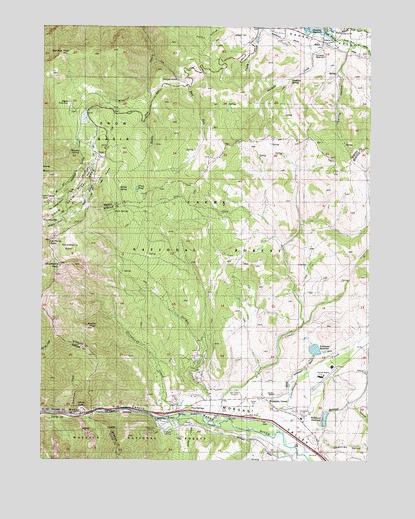
Snow Basin, UT USGS Topographic Map
Click on map above to begin viewing in our Map Viewer.

This topographic map contains these locations and features:
Feature Name Type Latitude Longitude GNIS ID View Map
Bear HollowValleyN41.2127°W111.8555°1438474View Map
Bear SpringSpringN41.1969°W111.8485°1438494View Map
Bear WallowFlatN41.2055°W111.8513°1438504View Map
Bohman HollowValleyN41.1344°W111.7694°1438989View Map
Breeze ArchArchN41.2400°W111.8700°2558332View Map
Chicken Spring CreekStreamN41.2258°W111.8594°1439683View Map
Cottonwood CreekStreamN41.1363°W111.8041°1440018View Map
De Moisy PeakSummitN41.1880°W111.8730°1440295View Map
Deadman GulchValleyN41.1311°W111.7685°1440311View Map
Devils GateGapN41.1399°W111.8605°1440428View Map
Dry CreekStreamN41.1441°W111.8058°1440595View Map
East Fork Wheeler CreekStreamN41.2408°W111.8336°1440824View Map
GatewayLocaleN41.1394°W111.8424°1441289View Map
Gateway TunnelTunnelN41.1333°W111.8647°1441291View Map
Gordon CreekStreamN41.1372°W111.8133°1441382View Map
Green PondLakeN41.2030°W111.8397°1441476View Map
Hawkins CreekStreamN41.2488°W111.7710°1441633View Map
Hawkins SpringSpringN41.2342°W111.7813°1441634View Map
Hill Air Force Base Recreation AreaParkN41.2177°W111.8413°1454768View Map
Huntsville ReservoirReservoirN41.2411°W111.7722°1441956View Map
Huntsville South Branch CanalCanalN41.2447°W111.7752°1441957View Map
Jacobs CreekStreamN41.1369°W111.8160°1442099View Map
Jefferson Hunt CampgroundLocaleN41.2488°W111.7674°1450181View Map
Maples Picnic AreaLocaleN41.2269°W111.8647°1443188View Map
Middle BowlBasinN41.1919°W111.8702°1443322View Map
Middle Fork Wheeler CreekStreamN41.2322°W111.8363°1443360View Map
Middle PeakSummitN41.1627°W111.8561°1443372View Map
Morgan County AirportAirportN41.1462°W111.7713°1447613View Map
Morgan County Community ChurchChurchN41.1424°W111.7877°1449298View Map
Morgan ValleyValleyN41.1397°W111.8233°1443586View Map
Mount Ogden BowlBasinN41.1974°W111.8697°1443626View Map
Mountain GreenPopulated PlaceN41.1430°W111.7916°1443637View Map
Mountain Green CemeteryCemeteryN41.1449°W111.8030°1443638View Map
Mountain Green Census Designated PlaceCensusN41.1475°W111.7900°2584772View Map
Mountain Green Fire DepartmentBuildingN41.1400°W111.7863°2627423View Map
Northwest Bench DitchCanalN41.1494°W111.7797°1443996View Map
Northwest ReservoirReservoirN41.1571°W111.7713°1430881View Map
Sardine PeakSummitN41.2422°W111.8686°1445335View Map
Snow BasinBasinN41.2199°W111.8491°1445732View Map
Snow Basin HeliportAirportN41.2199°W111.8574°1449013View Map
Snow Basin Ski AreaLocaleN41.2119°W111.8519°1454900View Map
South Arm CampgroundLocaleN41.2486°W111.7927°1449025View Map
South Branch South Fork Ogden RiverStreamN41.2488°W111.7652°1445795View Map
Spring HollowValleyN41.2441°W111.7591°1446044View Map
Strawberry BowlBasinN41.1847°W111.8655°1446176View Map
Strawberry CreekStreamN41.1372°W111.8280°1446179View Map
Strawberry MineMineN41.1336°W111.8330°1446185View Map
Strawberry PeakSummitN41.1808°W111.8691°1446187View Map
Tatterson CreekStreamN41.1386°W111.8649°1446343View Map
The NeedlesPillarN41.1933°W111.8738°1446483View Map
Trout SpringsSpringN41.1397°W111.8187°1446745View Map
Valley Lake EstatesPopulated PlaceN41.2477°W111.7858°1453588View Map
Warner SpringSpringN41.1331°W111.8257°1446992View Map
Wheeler SpringSpringN41.2144°W111.8636°1447215View Map
Wildcat CampgroundLocaleN41.2249°W111.8466°1449193View Map
Wildcat RunSlopeN41.2047°W111.8599°1447363View Map
Wilkinson ReservoirReservoirN41.1372°W111.7674°1447371View Map
Willow SpringSpringN41.2030°W111.8466°1447439View Map

Note: Coordinates in the location and feature list above are referenced to NAD83 datum.


Copyright (C) 2008-2024 Ryan Niemi / Sunset Dynamics ... All Rights Reserved