TopoQuest Logo
Do you find TopoQuest useful?
Help keep TopoQuest running and adding new maps/features by donating!
Bitcoin:  19c7KJd3qBynnjoSw5npx9KScwjBe4ifkT
Litecoin:  LXs6TkuXGGXo1vDsWCkWVdjQX94eUKd6ui
Home View Maps Find Maps Find Places Resources & Links


Snyder, Texas Topographic Map

USGS Map Title: Snyder, TX
USGS Map MRC: 32100F8
DRG (GeoTIFF) Download: o32100f8.tif


Neighboring USGS Topographic Map Quads:


  Dermott, TX  
32101G1
 

  Brand, TX  
32100G8
 

  Lloyd Mountain, TX  
32100G7
 

  Ira NE, TX  
32101F1
 

  Snyder, TX  
32100F8
 

  Hermleigh, TX  
32100F7
 

  Ira, TX  
32101E1
 

  Dunn, TX  
32100E8
 

  China Grove, TX  
32100E7


Map MRC Location:

N33°
W101°
N33°
W100°
H8 H7 H6 H5 H4 H3 H2 H1
G8 G7 G6 G5 G4 G3 G2 G1
F8 F7 F6 F5 F4 F3 F2 F1
E8 E7 E6 E5 E4 E3 E2 E1
D8 D7 D6 D5 D4 D3 D2 D1
C8 C7 C6 C5 C4 C3 C2 C1
B8 B7 B6 B5 B4 B3 B2 B1
A8 A7 A6 A5 A4 A3 A2 A1
N32°
W101°
N32°
W100°

Snyder, TX USGS 1:24K Topographic Map Preview:
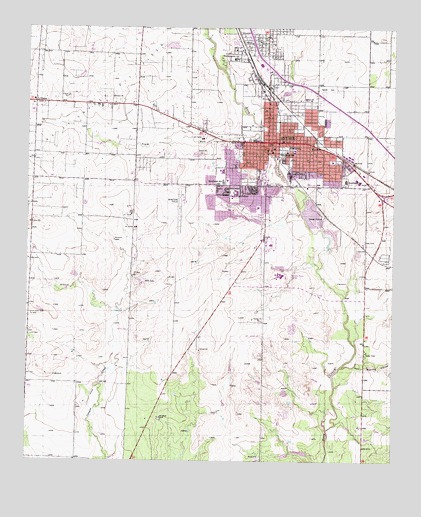
Snyder, TX USGS Topographic Map
Click on map above to begin viewing in our Map Viewer.

This topographic map contains these locations and features:
Feature Name Type Latitude Longitude GNIS ID View Map
Apostolic Faith ChurchChurchN32.7173°W100.9262°2023518View Map
Bautista Primera Iglesia ChurchChurchN32.7223°W100.9171°2023519View Map
Central Elementary SchoolSchoolN32.7151°W100.9096°2008846View Map
Church of GodChurchN32.7212°W100.9123°2023529View Map
City of SnyderCivilN32.7136°W100.9107°2411917View Map
Cogdell Memorial HospitalHospitalN32.6881°W100.9170°2015756View Map
Colonial Hill BaptistchurchChurchN32.7065°W100.9329°2023520View Map
East Elementary SchoolSchoolN32.7065°W100.8937°2008847View Map
Faith Baptist ChurchChurchN32.7046°W100.8960°2023521View Map
First Baptist ChurchChurchN32.7151°W100.9162°2023522View Map
First Presbyterian ChurchChurchN32.7159°W100.9173°2023533View Map
Grace Lutheran ChurchChurchN32.6901°W100.9193°2023530View Map
Hell Roaring HollowValleyN32.6524°W100.8929°1337573View Map
KSNY-AM (Snyder)TowerN32.7259°W100.9421°1385696View Map
Lincoln SchoolSchoolN32.7082°W100.9085°1339954View Map
Morningside Baptist ChurchChurchN32.7062°W100.8937°2023523View Map
Mount Olive Baptist ChurchChurchN32.7084°W100.9115°2023524View Map
New Hope Baptist ChurchChurchN32.7098°W100.9057°2023525View Map
North College Avenue Baptist ChurchChurchN32.7421°W100.9187°2023526View Map
North East ParkParkN32.7304°W100.9123°2029725View Map
Northeast Elementary SchoolSchoolN32.7290°W100.9046°2008851View Map
Northwest SchoolSchoolN32.7415°W100.9290°1342881View Map
Primitive Baptist ChurchChurchN32.7221°W100.9112°2023527View Map
Scurry CountyCivilN32.7463°W100.9164°1383993View Map
Scurry County CourthouseBuildingN32.7173°W100.9179°2030515View Map
Scurry County JailBuildingN32.7156°W100.9118°2738846View Map
Scurry County MuseumBuildingN32.7423°W100.9187°2014443View Map
Scurry County Sheriff's OfficeBuildingN32.7040°W100.9002°2750636View Map
SnyderPopulated PlaceN32.7179°W100.9176°1347340View Map
Snyder CemeteryCemeteryN32.7332°W100.8979°1347342View Map
Snyder City HallBuildingN32.7185°W100.9196°2753175View Map
Snyder Emergency Medical ServiceBuildingN32.7025°W100.9188°2656086View Map
Snyder Fire DepartmentBuildingN32.7154°W100.9193°2551934View Map
Snyder Fire Department AdministrationBuildingN32.7154°W100.9193°2552042View Map
Snyder High SchoolSchoolN32.7037°W100.9287°2008852View Map
Snyder Junior High SchoolSchoolN32.7098°W100.9335°2008853View Map
Snyder Police DepartmentBuildingN32.7040°W100.8995°2750510View Map
Snyder Post OfficePost OfficeN32.7186°W100.9164°2731648View Map
South Fork Deep CreekStreamN32.7193°W100.9207°1347442View Map
Southeast SchoolSchoolN32.7062°W100.8915°1347582View Map
Southwest Medical Evacuation Snyder BaseBuildingN32.6884°W100.9164°2656096View Map
Southwest SchoolSchoolN32.7059°W100.9332°1347607View Map
Spanish Church of ChristChurchN32.7368°W100.9182°2023528View Map
Stanfield Elementary SchoolSchoolN32.6990°W100.9232°2008854View Map
The Church of Jesus Christ of Latter Day SaintsChurchN32.7026°W100.9137°2023532View Map
Tiger StadiumParkN32.7026°W100.9321°2027624View Map
Trinity United Methodist ChurchChurchN32.6898°W100.9179°2023531View Map
UnionPopulated PlaceN32.7290°W100.9976°1349034View Map
West Elementary SchoolSchoolN32.7057°W100.9335°2008855View Map
Winston FieldAirportN32.7009°W100.9471°1387555View Map
Winston ParkParkN32.7034°W100.9104°2029892View Map

Note: Coordinates in the location and feature list above are referenced to NAD83 datum.


Copyright (C) 2008-2025 Ryan Niemi / Sunset Dynamics ... All Rights Reserved