TopoQuest Logo
Do you find TopoQuest useful?
Help keep TopoQuest running and adding new maps/features by donating!
Bitcoin:  19c7KJd3qBynnjoSw5npx9KScwjBe4ifkT
Litecoin:  LXs6TkuXGGXo1vDsWCkWVdjQX94eUKd6ui
Home View Maps Find Maps Find Places Resources & Links


Soap Lake, Washington Topographic Map

USGS Map Title: Soap Lake, WA
USGS Map MRC: 47119D4
DRG (GeoTIFF) Download: o47119d4.tif


Neighboring USGS Topographic Map Quads:


  Jameson Lake SE, WA  
47119E5
 

  Park Lake, WA  
47119E4
 

  Coulee City, WA  
47119E3
 

  Little Soap Lake, WA  
47119D5
 

  Soap Lake, WA  
47119D4
 

  Stratford, WA  
47119D3
 

  Ephrata, WA  
47119C5
 

  Grant Orchards, WA  
47119C4
 

  Gloyd, WA  
47119C3


Map MRC Location:

N48°
W120°
N48°
W119°
H8 H7 H6 H5 H4 H3 H2 H1
G8 G7 G6 G5 G4 G3 G2 G1
F8 F7 F6 F5 F4 F3 F2 F1
E8 E7 E6 E5 E4 E3 E2 E1
D8 D7 D6 D5 D4 D3 D2 D1
C8 C7 C6 C5 C4 C3 C2 C1
B8 B7 B6 B5 B4 B3 B2 B1
A8 A7 A6 A5 A4 A3 A2 A1
N47°
W120°
N47°
W119°

Soap Lake, WA USGS 1:24K Topographic Map Preview:
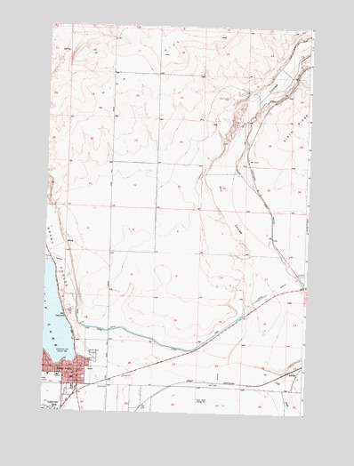
Soap Lake, WA USGS Topographic Map
Click on map above to begin viewing in our Map Viewer.

This topographic map contains these locations and features:
Feature Name Type Latitude Longitude GNIS ID View Map
Adco SidingLocaleN47.4157°W119.3750°1511460View Map
Calling the Healing Waters Sculpture and SundialParkN47.3919°W119.4848°2681621View Map
City of Soap LakeCivilN47.3888°W119.4909°2411918View Map
Delancey-Houghton Elementary SchoolSchoolN47.3857°W119.4859°1514974View Map
Grand CouleeValleyN47.3915°W119.4906°1513283View Map
High HillSummitN47.4913°W119.4453°1505500View Map
Lower Grand CouleeValleyN47.3915°W119.4906°1506354View Map
Smokiam CampgroundLocaleN47.3908°W119.4844°2681618View Map
Soap LakeLakeN47.4056°W119.4963°1508485View Map
Soap LakePopulated PlaceN47.3893°W119.4906°1512667View Map
Soap Lake City Police DepartmentBuildingN47.3870°W119.4861°2721907View Map
Soap Lake Elementary SchoolSchoolN47.3848°W119.4974°2681619View Map
Soap Lake Fire DepartmentBuildingN47.3870°W119.4857°2619352View Map
Soap Lake Middle - High SchoolSchoolN47.3866°W119.4972°1514973View Map
Soap Lake Post OfficePost OfficeN47.3841°W119.4911°2781583View Map

Note: Coordinates in the location and feature list above are referenced to NAD83 datum.


Copyright (C) 2008-2025 Ryan Niemi / Sunset Dynamics ... All Rights Reserved