TopoQuest Logo
Do you find TopoQuest useful?
Help keep TopoQuest running and adding new maps/features by donating!
Bitcoin:  19c7KJd3qBynnjoSw5npx9KScwjBe4ifkT
Litecoin:  LXs6TkuXGGXo1vDsWCkWVdjQX94eUKd6ui
Home View Maps Find Maps Find Places Resources & Links


Sperry, Iowa Topographic Map

USGS Map Title: Sperry, IA
USGS Map MRC: 40091H2
DRG (GeoTIFF) Download: o40091h2.tif


Neighboring USGS Topographic Map Quads:


  Morning Sun, IA  
41091A3
 

  Mediapolis, IA  
41091A2
 

  Oakville, IA  
41091A1
 

  Pleasant Grove, IA  
40091H3
 

  Sperry, IA  
40091H2
 

  Kingston, IA  
40091H1
 

  Danville, IA  
40091G3
 

  West Burlington, IA  
40091G2
 

  Burlington, IA  
40091G1


Map MRC Location:

N41°
W92°
N41°
W91°
H8 H7 H6 H5 H4 H3 H2 H1
G8 G7 G6 G5 G4 G3 G2 G1
F8 F7 F6 F5 F4 F3 F2 F1
E8 E7 E6 E5 E4 E3 E2 E1
D8 D7 D6 D5 D4 D3 D2 D1
C8 C7 C6 C5 C4 C3 C2 C1
B8 B7 B6 B5 B4 B3 B2 B1
A8 A7 A6 A5 A4 A3 A2 A1
N40°
W92°
N40°
W91°

Sperry, IA USGS 1:24K Topographic Map Preview:
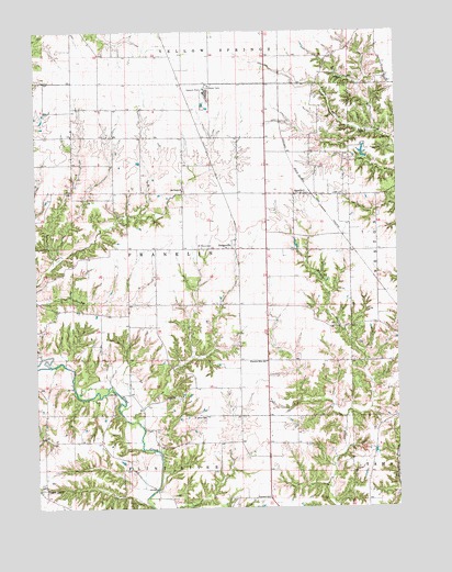
Sperry, IA USGS Topographic Map
Click on map above to begin viewing in our Map Viewer.

This topographic map contains these locations and features:
Feature Name Type Latitude Longitude GNIS ID View Map
Big Hollow Creek Recreation AreaParkN40.9500°W91.2279°1994910View Map
Criner CemeteryCemeteryN40.8778°W91.1265°1995139View Map
Des Moines CountyCivilN40.9232°W91.1815°465217View Map
DodgevillePopulated PlaceN40.9431°W91.1807°455937View Map
Dodgeville Post Office (historical)Post OfficeN40.9431°W91.1807°1994917View Map
Excelsior SchoolSchoolN40.8775°W91.1699°456452View Map
Flint River BridgeBridgeN40.9050°W91.2224°1995209View Map
Franklin Mills CemeteryCemeteryN40.9084°W91.1501°1995156View Map
Franklin Mills Post Office (historical)Post OfficeN40.9014°W91.1835°1994916View Map
Franklin Mills SchoolSchoolN40.9134°W91.1701°456733View Map
Freitag CemeteryCemeteryN40.9133°W91.1254°1995138View Map
Jackson CemeteryCemeteryN40.9400°W91.1799°1995162View Map
KlinePopulated PlaceN40.9223°W91.2090°464321View Map
Kline Post Office (historical)Post OfficeN40.9223°W91.2090°1994915View Map
Loper CemeteryCemeteryN40.9573°W91.1424°458613View Map
Old Stone CemeteryCemeteryN40.9578°W91.1988°1995163View Map
Old Stone ChurchChurchN40.9584°W91.1985°459839View Map
Prairie Grove CemeteryCemeteryN40.8814°W91.2485°1995157View Map
Saint John's United CemeteryCemeteryN40.8982°W91.1922°1995159View Map
Saint Johns ChurchChurchN40.8986°W91.1918°461039View Map
Saint Mary's ChurchChurchN40.9434°W91.1840°1995062View Map
Saint Marys CemeteryCemeteryN40.9434°W91.1896°461156View Map
Salem ChurchChurchN40.9036°W91.2043°461363View Map
Salem Lutheran CemeteryCemeteryN40.9033°W91.2046°1995160View Map
Schilb CemeteryCemeteryN40.8955°W91.2124°1995158View Map
Seven Ponds ParkParkN40.9667°W91.1349°1995063View Map
SperryPopulated PlaceN40.9570°W91.1565°461847View Map
Sperry (historical)LocaleN40.9578°W91.1507°1995058View Map
Sperry MineMineN40.9828°W91.1908°2725189View Map
Sperry Post OfficePost OfficeN40.9570°W91.1565°1995059View Map
Thie Farm CemeteryCemeteryN40.9195°W91.1890°1995161View Map
Township of FranklinCivilN40.9428°W91.1989°467854View Map
United Methodist ChurchChurchN40.9575°W91.1563°1995060View Map
Zion School MuseumBuildingN40.9217°W91.2279°1994909View Map

Note: Coordinates in the location and feature list above are referenced to NAD83 datum.


Copyright (C) 2008-2025 Ryan Niemi / Sunset Dynamics ... All Rights Reserved