TopoQuest Logo
Do you find TopoQuest useful?
Help keep TopoQuest running and adding new maps/features by donating!
Bitcoin:  19c7KJd3qBynnjoSw5npx9KScwjBe4ifkT
Litecoin:  LXs6TkuXGGXo1vDsWCkWVdjQX94eUKd6ui
Home View Maps Find Maps Find Places Resources & Links


Spicer Bay, North Carolina Topographic Map

USGS Map Title: Spicer Bay, NC
USGS Map MRC: 34077D4
DRG (GeoTIFF) Download: o34077d4.tif


Neighboring USGS Topographic Map Quads:


  Folkstone, NC  
34077E5
 

  Sneads Ferry, NC  
34077E4
 

  New River Inlet, NC  
34077E3
 

  Holly Ridge, NC  
34077D5
 

  Spicer Bay, NC  
34077D4


Map MRC Location:

N35°
W78°
N35°
W77°
H8 H7 H6 H5 H4 H3 H2 H1
G8 G7 G6 G5 G4 G3 G2 G1
F8 F7 F6 F5 F4 F3 F2 F1
E8 E7 E6 E5 E4 E3 E2 E1
D8 D7 D6 D5 D4 D3 D2 D1
C8 C7 C6 C5 C4 C3 C2 C1
B8 B7 B6 B5 B4 B3 B2 B1
A8 A7 A6 A5 A4 A3 A2 A1
N34°
W78°
N34°
W77°

Spicer Bay, NC USGS 1:24K Topographic Map Preview:
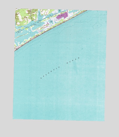
Spicer Bay, NC USGS Topographic Map
Click on map above to begin viewing in our Map Viewer.

This topographic map contains these locations and features:
Feature Name Type Latitude Longitude GNIS ID View Map
Ashe IslandIslandN34.4782°W77.4664°980319View Map
Everett BayBayN34.4827°W77.4708°984866View Map
Goose BayBayN34.4993°W77.4400°985813View Map
Kings CreekStreamN34.4768°W77.4922°987997View Map
North Topsail BeachPopulated PlaceN34.4902°W77.4316°1027625View Map
North Topsail Beach Fire Department South StationBuildingN34.4578°W77.4925°2638923View Map
North Topsail Beach Police DepartmentBuildingN34.4929°W77.4255°2130849View Map
Ocean City BeachPopulated PlaceN34.4566°W77.4914°1008316View Map
Onslow County Emergency Medical Services Station 7BuildingN34.4578°W77.4925°2720470View Map
Permuda IslandIslandN34.4688°W77.4930°992049View Map
Rogers BayBayN34.4860°W77.4519°993642View Map
Sea Haven BeachBeachN34.4641°W77.4766°1008315View Map
Spicer BayBayN34.4799°W77.4894°995300View Map
Stump Inlet (historical)GutN34.4707°W77.4630°1003150View Map
Stump SoundBayN34.4802°W77.4819°995621View Map
Thomas LandingPopulated PlaceN34.4868°W77.4764°1022937View Map
Topsail IslandIslandN34.4696°W77.4719°1802790View Map
Town of North Topsail BeachCivilN34.4938°W77.4319°2407008View Map
Turkey CreekStreamN34.4854°W77.4680°996324View Map
Turkey PointCapeN34.4929°W77.4652°996343View Map

Note: Coordinates in the location and feature list above are referenced to NAD83 datum.


Copyright (C) 2008-2024 Ryan Niemi / Sunset Dynamics ... All Rights Reserved