TopoQuest Logo
Do you find TopoQuest useful?
Help keep TopoQuest running and adding new maps/features by donating!
Bitcoin:  19c7KJd3qBynnjoSw5npx9KScwjBe4ifkT
Litecoin:  LXs6TkuXGGXo1vDsWCkWVdjQX94eUKd6ui
Home View Maps Find Maps Find Places Resources & Links


Springfield, Louisiana Topographic Map

USGS Map Title: Springfield, LA
USGS Map MRC: 30090D5
DRG (GeoTIFF) Download: o30090d5.tif


Neighboring USGS Topographic Map Quads:


  Holden, LA  
30090E6
 

  Albany, LA  
30090E5
 

  Hammond, LA  
30090E4
 

  Frost, LA  
30090D6
 

  Springfield, LA  
30090D5
 

  Ponchatoula, LA  
30090D4
 

  Whitehall, LA  
30090C6
 

  Killian, LA  
30090C5
 

  Manchac, LA  
30090C4


Map MRC Location:

N31°
W91°
N31°
W90°
H8 H7 H6 H5 H4 H3 H2 H1
G8 G7 G6 G5 G4 G3 G2 G1
F8 F7 F6 F5 F4 F3 F2 F1
E8 E7 E6 E5 E4 E3 E2 E1
D8 D7 D6 D5 D4 D3 D2 D1
C8 C7 C6 C5 C4 C3 C2 C1
B8 B7 B6 B5 B4 B3 B2 B1
A8 A7 A6 A5 A4 A3 A2 A1
N30°
W91°
N30°
W90°

Springfield, LA USGS 1:24K Topographic Map Preview:
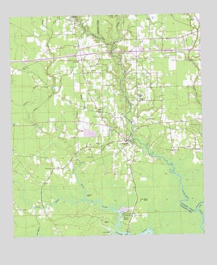
Springfield, LA USGS Topographic Map
Click on map above to begin viewing in our Map Viewer.

This topographic map contains these locations and features:
Feature Name Type Latitude Longitude GNIS ID View Map
Albany High SchoolSchoolN30.4994°W90.5877°532099View Map
Albany Post OfficePost OfficeN30.4989°W90.5832°1631795View Map
Bankstons Mobile Home ParkPopulated PlaceN30.4897°W90.5799°2600384View Map
Bethlehem Baptist ChurchChurchN30.4949°W90.5818°551983View Map
Bible Baptist ChurchChurchN30.4691°W90.5005°2601400View Map
Blockade LandingLocaleN30.4146°W90.5231°551987View Map
Blood RiverStreamN30.3766°W90.5529°553715View Map
Blood River ChurchChurchN30.4138°W90.5987°533228View Map
Booth Shell BankLocaleN30.3788°W90.5362°551988View Map
Breed BranchStreamN30.4257°W90.5851°533377View Map
Brier Patch IslandFlatN30.3949°W90.5356°533397View Map
Butler BayouStreamN30.3755°W90.6090°533582View Map
Carter LandingLocaleN30.4049°W90.5804°551994View Map
Carter PlantationLocaleN30.4141°W90.5776°551995View Map
Carter Plantation Golf CourseLocaleN30.4124°W90.5742°2601347View Map
Carters CemeteryCemeteryN30.4166°W90.5770°553908View Map
CemeteryCemeteryN30.4951°W90.5803°2774666View Map
Cullom CemeteryCemeteryN30.4216°W90.5379°552002View Map
Cullom LandingLocaleN30.4191°W90.5334°552003View Map
Doe BranchStreamN30.4971°W90.5523°534547View Map
Duncans BluffCliffN30.3980°W90.5765°534654View Map
Faith Gospel Bible InstituteChurchN30.4608°W90.6009°2601627View Map
First United Methodist Church of SpringfieldChurchN30.4291°W90.5493°552015View Map
Galilee Baptist ChurchChurchN30.4460°W90.5654°554500View Map
Galilee CemeteryCemeteryN30.4427°W90.5679°535151View Map
Gatlin School (historical)SchoolN30.4588°W90.5429°549661View Map
Goodwill ChurchChurchN30.4607°W90.6009°535277View Map
Hickory BranchStreamN30.4394°W90.6104°535645View Map
Holly ChurchChurchN30.4274°W90.5679°535719View Map
Hungarian CemeteryCemeteryN30.4677°W90.5729°552025View Map
Hungarian ChurchChurchN30.4677°W90.5723°554801View Map
Hungarian School (historical)SchoolN30.4677°W90.5779°552026View Map
Hungarian SettlementPopulated PlaceN30.4674°W90.5773°552027View Map
Interchange 32CrossingN30.4780°W90.5787°541448View Map
Interchange 35CrossingN30.4794°W90.5423°541449View Map
Jack IslandIslandN30.3763°W90.5668°535977View Map
James ChapelChurchN30.4716°W90.6151°535999View Map
James Chapel CemeteryCemeteryN30.4713°W90.6145°552029View Map
James Chapel United Methodist ChurchChurchN30.4820°W90.5789°2602083View Map
Jerusalem Baptist ChurchChurchN30.4516°W90.5384°554874View Map
Jim's Mobile Home ParkPopulated PlaceN30.3836°W90.5465°2600436View Map
Landon Mobile Home ParkPopulated PlaceN30.4737°W90.5410°2600446View Map
Little Natalbany RiverStreamN30.4849°W90.5573°1627530View Map
Lizard CreekStreamN30.3955°W90.5779°536641View Map
Lobell Farms DamDamN30.4319°W90.5734°556965View Map
Macedonia ChurchChurchN30.4410°W90.5348°536795View Map
Mount Olive Baptist ChurchChurchN30.4841°W90.5188°2602376View Map
Parker BranchStreamN30.4919°W90.5968°537973View Map
Ponchatoula CreekStreamN30.3894°W90.5043°555700View Map
Pumpkin CenterPopulated PlaceN30.4549°W90.5420°543603View Map
Redemption Christian CenterChurchN30.4869°W90.5103°2602432View Map
RobinwoodPopulated PlaceN30.4752°W90.5056°549738View Map
RomePopulated PlaceN30.3771°W90.5506°552057View Map
Rome Ferry BridgeBridgeN30.3763°W90.5506°552058View Map
Romes Ferry (historical)CrossingN30.3763°W90.5506°552059View Map
RosaryvillePopulated PlaceN30.4230°W90.5195°555832View Map
Rosaryville Spirit Life CenterChurchN30.4230°W90.5201°549739View Map
Rose MoundSummitN30.3827°W90.5659°543628View Map
Saint James ChurchChurchN30.4224°W90.5440°538855View Map
Saint Margarets CemeteryCemeteryN30.4719°W90.5815°552062View Map
Saint Margarets ChurchChurchN30.4738°W90.5801°555911View Map
Simeon BranchStreamN30.4155°W90.5795°539379View Map
SpringfieldPopulated PlaceN30.4291°W90.5487°556125View Map
Springfield CemeteryCemeteryN30.4312°W90.5507°552073View Map
SPRINGFIELD ELEMENTARY SCHOOLSchoolN30.4285°W90.5511°552071View Map
Springfield Head Start SchoolSchoolN30.4193°W90.5654°2600265View Map
Springfield High SchoolSchoolN30.4296°W90.5514°552072View Map
Springfield Middle SchoolSchoolN30.4175°W90.5604°2434800View Map
Springfield Police DepartmentBuildingN30.4292°W90.5495°2334060View Map
Springfield Post OfficePost OfficeN30.4290°W90.5474°1631830View Map
Springfield Volunteer Fire DepartmentBuildingN30.4252°W90.5475°2691732View Map
Starnee ChurchChurchN30.4860°W90.5193°539635View Map
Tilman ParkPopulated PlaceN30.4846°W90.5115°549782View Map
Town of SpringfieldCivilN30.4256°W90.5444°2407389View Map
Trinity Baptist ChurchChurchN30.4607°W90.5415°556268View Map
Tucker LandingLocaleN30.3932°W90.5743°552081View Map
Turkey CreekStreamN30.4871°W90.5987°540031View Map
Vacajun MarinaHarborN30.3890°W90.5524°2601267View Map
Wadesboro CemeteryCemeteryN30.4241°W90.5109°540187View Map
Ward FourCivilN30.4396°W90.6223°545120View Map
Warsaw LandingPopulated PlaceN30.3849°W90.5534°556363View Map
Warsaw MarinaHarborN30.3885°W90.5547°2601268View Map
Woodland Baptist ChurchChurchN30.3905°W90.6193°556467View Map

Note: Coordinates in the location and feature list above are referenced to NAD83 datum.


Copyright (C) 2008-2025 Ryan Niemi / Sunset Dynamics ... All Rights Reserved