TopoQuest Logo
Do you find TopoQuest useful?
Help keep TopoQuest running and adding new maps/features by donating!
Bitcoin:  19c7KJd3qBynnjoSw5npx9KScwjBe4ifkT
Litecoin:  LXs6TkuXGGXo1vDsWCkWVdjQX94eUKd6ui
Home View Maps Find Maps Find Places Resources & Links


Squaxin Island, Washington Topographic Map

USGS Map Title: Squaxin Island, WA
USGS Map MRC: 47122B8
DRG (GeoTIFF) Download: o47122b8.tif


Neighboring USGS Topographic Map Quads:


  Union, WA  
47123C1
 

  Mason Lake, WA  
47122C8
 

  Vaughn, WA  
47122C7
 

  Shelton, WA  
47123B1
 

  Squaxin Island, WA  
47122B8
 

  Longbranch, WA  
47122B7
 

  Summit Lake, WA  
47123A1
 

  Tumwater, WA  
47122A8
 

  Lacey, WA  
47122A7


Map MRC Location:

N48°
W123°
N48°
W122°
H8 H7 H6 H5 H4 H3 H2 H1
G8 G7 G6 G5 G4 G3 G2 G1
F8 F7 F6 F5 F4 F3 F2 F1
E8 E7 E6 E5 E4 E3 E2 E1
D8 D7 D6 D5 D4 D3 D2 D1
C8 C7 C6 C5 C4 C3 C2 C1
B8 B7 B6 B5 B4 B3 B2 B1
A8 A7 A6 A5 A4 A3 A2 A1
N47°
W123°
N47°
W122°

Squaxin Island, WA USGS 1:24K Topographic Map Preview:
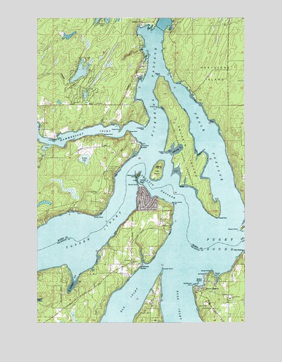
Squaxin Island, WA USGS Topographic Map
Click on map above to begin viewing in our Map Viewer.

This topographic map contains these locations and features:
Feature Name Type Latitude Longitude GNIS ID View Map
ArcadiaPopulated PlaceN47.1979°W122.9396°1510785View Map
Arcadia PointCapeN47.1984°W122.9385°1514756View Map
Belspeox PointCapeN47.1809°W122.9151°1509705View Map
Big Twin LakeLakeN47.2277°W122.9751°1511793View Map
Boston HarborPopulated PlaceN47.1384°W122.9010°1512019View Map
Boston HarborBayN47.1416°W122.9032°1531698View Map
Boston Harbor Elementary SchoolSchoolN47.1348°W122.8852°1530812View Map
Brisco PointCapeN47.1629°W122.8796°1503551View Map
Cape CodCapeN47.2037°W122.9463°1503793View Map
Cape HornCapeN47.2032°W122.9515°1503797View Map
Carlyon BeachPopulated PlaceN47.1795°W122.9399°1531667View Map
Carlyon Beach Sewage Treatment PlantLocaleN47.1750°W122.9331°2610707View Map
Cooper PointCapeN47.1468°W122.9260°1504134View Map
Dofflemyer PointCapeN47.1404°W122.9074°1533035View Map
Dofflemyer Point LighthouseBuildingN47.1409°W122.9074°1514904View Map
Dover PointCapeN47.1462°W122.8957°1504526View Map
Edgewater BeachPopulated PlaceN47.1509°W122.9321°1511881View Map
Forbes LakeLakeN47.1919°W122.9724°1504946View Map
Gallagher CoveBayN47.1421°W122.9791°1505073View Map
Graham PointPopulated PlaceN47.2476°W122.9379°1511006View Map
Harstine IslandIslandN47.2318°W122.8863°1510708View Map
Hope IslandIslandN47.1873°W122.9288°1505598View Map
Hungerford PointCapeN47.2076°W122.9363°1531709View Map
Hunter PointCapeN47.1734°W122.9193°1533042View Map
Jeal PointCapeN47.1443°W122.8999°1531697View Map
Libby PointCapeN47.2001°W122.9896°1531700View Map
Libby Point LightLocaleN47.2001°W122.9896°1506145View Map
Little FishtrapBayN47.1535°W122.8766°1509709View Map
Little Twin LakeReservoirN47.2184°W122.9721°1532048View Map
Littletwin Lakes DamDamN47.2165°W122.9729°1532047View Map
Mason County Fire District 4 Station 43BuildingN47.1782°W122.9652°2643847View Map
Mason County Fire District 5 Station 5 AgateBuildingN47.2145°W122.9658°2643840View Map
Mill CreekStreamN47.1979°W122.9932°1533051View Map
Palela BayBayN47.1952°W122.9188°1533649View Map
Peale PassageChannelN47.1970°W122.8965°1507343View Map
Potlatch PointCapeN47.1976°W122.9215°1531708View Map
RignallPopulated PlaceN47.1651°W122.9226°1531696View Map
Rignall HallBuildingN47.1495°W122.9446°1507804View Map
Salmon PointCapeN47.2257°W122.9271°1508058View Map
Sanderson HarborLocaleN47.1487°W122.9399°1508102View Map
Sandy PointCapeN47.1823°W122.9404°1508115View Map
Seafarm CoveBayN47.1941°W122.9040°1509707View Map
Squaxin IslandIslandN47.1948°W122.9104°1508670View Map
Squaxin Island ReservationCivilN47.1960°W122.9110°1508671View Map
Squaxin Island State Park (historical)ParkN47.1734°W122.8943°1511788View Map
Squaxin PassageChannelN47.1801°W122.9290°1508672View Map
Steamboat IslandIslandN47.1851°W122.9399°1508706View Map
Thurston County Fire District 13 Griffin Fire Department Station 13 - 2BuildingN47.1495°W122.9463°2643328View Map
Timber Lake-Harstine Island DivisionCivilN47.2424°W122.9272°2628215View Map
Timberlakes DamDamN47.2232°W122.9813°1532045View Map
Tuckapahwox PointCapeN47.2132°W122.9276°1509708View Map
Tucksel PointCapeN47.1679°W122.8926°1510417View Map
Windy PointCapeN47.1690°W122.9663°1509593View Map
Zangle CoveBayN47.1449°W122.8923°1509674View Map

Note: Coordinates in the location and feature list above are referenced to NAD83 datum.


Copyright (C) 2008-2025 Ryan Niemi / Sunset Dynamics ... All Rights Reserved