TopoQuest Logo
Do you find TopoQuest useful?
Help keep TopoQuest running and adding new maps/features by donating!
Bitcoin:  19c7KJd3qBynnjoSw5npx9KScwjBe4ifkT
Litecoin:  LXs6TkuXGGXo1vDsWCkWVdjQX94eUKd6ui
Home View Maps Find Maps Find Places Resources & Links


Stahl, Missouri Topographic Map

USGS Map Title: Stahl, MO
USGS Map MRC: 40092C7
DRG (GeoTIFF) Download: o40092c7.tif


Neighboring USGS Topographic Map Quads:


  Unionville East, MO  
40092D8
 

  Graysville, MO  
40092D7
 

  Livonia, MO  
40092D6
 

  Green City, MO  
40092C8
 

  Stahl, MO  
40092C7
 

  Connelsville, MO  
40092C6
 

  Mystic, MO  
40092B8
 

  Pure Air, MO  
40092B7
 

  Novinger, MO  
40092B6


Map MRC Location:

N41°
W93°
N41°
W92°
H8 H7 H6 H5 H4 H3 H2 H1
G8 G7 G6 G5 G4 G3 G2 G1
F8 F7 F6 F5 F4 F3 F2 F1
E8 E7 E6 E5 E4 E3 E2 E1
D8 D7 D6 D5 D4 D3 D2 D1
C8 C7 C6 C5 C4 C3 C2 C1
B8 B7 B6 B5 B4 B3 B2 B1
A8 A7 A6 A5 A4 A3 A2 A1
N40°
W93°
N40°
W92°

Stahl, MO USGS 1:24K Topographic Map Preview:
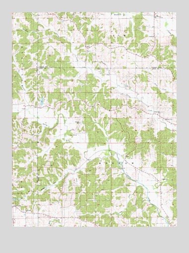
Stahl, MO USGS Topographic Map
Click on map above to begin viewing in our Map Viewer.

This topographic map contains these locations and features:
Feature Name Type Latitude Longitude GNIS ID View Map
Branstutter CemeteryCemeteryN40.3034°W92.8321°714639View Map
Clark School (historical)SchoolN40.3717°W92.8288°741557View Map
Cox CemeteryCemeteryN40.3420°W92.8091°716428View Map
Dewey (historical)LocaleN40.2895°W92.8216°740228View Map
Dry BranchStreamN40.3184°W92.8635°717078View Map
Featherly BranchStreamN40.3653°W92.8510°717873View Map
Green Castle CemeteryCemeteryN40.2593°W92.8659°718779View Map
Husted CemeteryCemeteryN40.3609°W92.7674°720047View Map
Husted School (historical)SchoolN40.3675°W92.7733°741560View Map
Jobs CreekStreamN40.2884°W92.8171°720329View Map
Lick BranchStreamN40.3084°W92.8513°721014View Map
Megrew CemeteryCemeteryN40.2778°W92.7616°722202View Map
Morelock CemeteryCemeteryN40.3106°W92.8249°722604View Map
Morelock SchoolSchoolN40.3228°W92.8299°741556View Map
Pleasant CreekStreamN40.3353°W92.8019°724472View Map
Plum BranchStreamN40.2828°W92.8244°724662View Map
Port Arthur School (historical)SchoolN40.2911°W92.8313°741555View Map
Red SchoolSchoolN40.2767°W92.7730°741558View Map
Shibleys PointPopulated PlaceN40.3134°W92.7610°741263View Map
Shibleys Point CemeteryCemeteryN40.3164°W92.7621°726351View Map
Shibleys Point SchoolSchoolN40.3211°W92.7721°741559View Map
SidneyPopulated PlaceN40.3542°W92.8191°741264View Map
South Crawford SchoolSchoolN40.2628°W92.8296°741554View Map
Spring Creek Ranch DamDamN40.3217°W92.8519°761162View Map
Spring Creek Ranch LakeReservoirN40.3231°W92.8525°761163View Map
StahlPopulated PlaceN40.2914°W92.7891°741280View Map
Stroup SidingLocaleN40.2767°W92.7733°740229View Map
Township of MorrowCivilN40.2770°W92.7997°766213View Map
Turkey CreekStreamN40.2725°W92.7735°727853View Map
Wood SchoolSchoolN40.3231°W92.8749°741553View Map

Note: Coordinates in the location and feature list above are referenced to NAD83 datum.


Copyright (C) 2008-2024 Ryan Niemi / Sunset Dynamics ... All Rights Reserved