TopoQuest Logo
Do you find TopoQuest useful?
Help keep TopoQuest running and adding new maps/features by donating!
Bitcoin:  19c7KJd3qBynnjoSw5npx9KScwjBe4ifkT
Litecoin:  LXs6TkuXGGXo1vDsWCkWVdjQX94eUKd6ui
Home View Maps Find Maps Find Places Resources & Links


Stamford, Nebraska Topographic Map

USGS Map Title: Stamford, NE
USGS Map MRC: 40099B5
DRG (GeoTIFF) Download: o40099b5.tif


Neighboring USGS Topographic Map Quads:


  Oxford, NE  
40099C6
 

  Mascot, NE  
40099C5
 

  Atlanta, NE  
40099C4
 

  Hollinger, NE  
40099B6
 

  Stamford, NE  
40099B5
 

  Orleans, NE  
40099B4
 

  Precept, NE  
40099A6
 

  Stamford SE, NE  
40099A5
 

  Alma SW, NE  
40099A4


Map MRC Location:

N41°
W100°
N41°
W99°
H8 H7 H6 H5 H4 H3 H2 H1
G8 G7 G6 G5 G4 G3 G2 G1
F8 F7 F6 F5 F4 F3 F2 F1
E8 E7 E6 E5 E4 E3 E2 E1
D8 D7 D6 D5 D4 D3 D2 D1
C8 C7 C6 C5 C4 C3 C2 C1
B8 B7 B6 B5 B4 B3 B2 B1
A8 A7 A6 A5 A4 A3 A2 A1
N40°
W100°
N40°
W99°

Stamford, NE USGS 1:24K Topographic Map Preview:
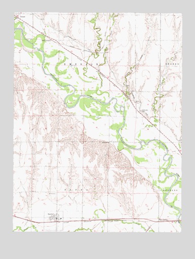
Stamford, NE USGS Topographic Map
Click on map above to begin viewing in our Map Viewer.

This topographic map contains these locations and features:
Feature Name Type Latitude Longitude GNIS ID View Map
Carter (historical)LocaleN40.1945°W99.5346°1875537View Map
Carter Post Office (historical)Post OfficeN40.1945°W99.5346°1875536View Map
Carter School (historical)SchoolN40.1947°W99.5304°827955View Map
Crow DamDamN40.2150°W99.6204°1767699View Map
Crow ReservoirReservoirN40.2146°W99.6200°1767700View Map
Deep CreekStreamN40.2111°W99.5601°828640View Map
Evangelical Free ChurchChurchN40.1331°W99.5929°1875551View Map
Flynn JunctionPopulated PlaceN40.1314°W99.5162°835306View Map
Foster CreekStreamN40.1956°W99.5432°829363View Map
Frear DamDamN40.2050°W99.6037°1769344View Map
Frear ReservoirReservoirN40.2043°W99.6036°1769345View Map
Murdock DamDamN40.2000°W99.5321°1769980View Map
Murdock ReservoirReservoirN40.2007°W99.5317°1769981View Map
Oxford JunctionPopulated PlaceN40.2350°W99.5990°835403View Map
School CreekStreamN40.1767°W99.5312°833264View Map
School Number 30SchoolN40.1761°W99.5543°836552View Map
Spring CreekStreamN40.2020°W99.5518°833690View Map
StamfordPopulated PlaceN40.1331°W99.5929°833760View Map
StamfordLocaleN40.1306°W99.5948°1875552View Map
Stamford CemeteryCemeteryN40.1469°W99.5934°833761View Map
Stamford Dam 2-ADamN40.1478°W99.5834°1767706View Map
Stamford Dam 3-ADamN40.1477°W99.5984°1767708View Map
Stamford ElevatorLocaleN40.1331°W99.5929°1875550View Map
Stamford Post OfficePost OfficeN40.1323°W99.5930°1875548View Map
Stamford Reservoir 2-ALakeN40.1489°W99.5836°1767707View Map
Stamford Reservoir 3-ALakeN40.1489°W99.5981°1767709View Map
Stamford School (historical)SchoolN40.1325°W99.5896°1875553View Map
Stamford Volunteer Fire DepartmentBuildingN40.1321°W99.5925°2553344View Map
Township of EmersonCivilN40.2200°W99.5735°837991View Map
Township of SappaCivilN40.1327°W99.5735°838228View Map
Trinity Lutheran ChurchChurchN40.1331°W99.5929°1875549View Map
Village of StamfordCivilN40.1312°W99.5944°2399883View Map

Note: Coordinates in the location and feature list above are referenced to NAD83 datum.


Copyright (C) 2008-2024 Ryan Niemi / Sunset Dynamics ... All Rights Reserved