TopoQuest Logo
Do you find TopoQuest useful?
Help keep TopoQuest running and adding new maps/features by donating!
Bitcoin:  19c7KJd3qBynnjoSw5npx9KScwjBe4ifkT
Litecoin:  LXs6TkuXGGXo1vDsWCkWVdjQX94eUKd6ui
Home View Maps Find Maps Find Places Resources & Links


Stampede Pass, Washington Topographic Map

USGS Map Title: Stampede Pass, WA
USGS Map MRC: 47121C3
DRG (GeoTIFF) Download: o47121c3.tif


Neighboring USGS Topographic Map Quads:


  Snoqualmie Pass, WA  
47121D4
 

  Chikamin Peak, WA  
47121D3
 

  Polallie Ridge, WA  
47121D2
 

  Lost Lake, WA  
47121C4
 

  Stampede Pass, WA  
47121C3
 

  Kachess Lake, WA  
47121C2
 

  Lester, WA  
47121B4
 

  Blowout Mountain, WA  
47121B3
 

  Easton, WA  
47121B2


Map MRC Location:

N48°
W122°
N48°
W121°
H8 H7 H6 H5 H4 H3 H2 H1
G8 G7 G6 G5 G4 G3 G2 G1
F8 F7 F6 F5 F4 F3 F2 F1
E8 E7 E6 E5 E4 E3 E2 E1
D8 D7 D6 D5 D4 D3 D2 D1
C8 C7 C6 C5 C4 C3 C2 C1
B8 B7 B6 B5 B4 B3 B2 B1
A8 A7 A6 A5 A4 A3 A2 A1
N47°
W122°
N47°
W121°

Stampede Pass, WA USGS 1:24K Topographic Map Preview:
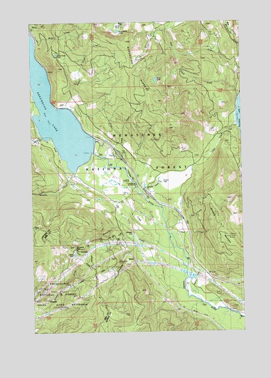
Stampede Pass, WA USGS Topographic Map
Click on map above to begin viewing in our Map Viewer.

This topographic map contains these locations and features:
Feature Name Type Latitude Longitude GNIS ID View Map
Amabilis MountainSummitN47.2887°W121.2587°1515841View Map
Baker LakeLakeN47.3515°W121.3017°1516053View Map
Bakers CampLocaleN47.3443°W121.2601°1529856View Map
Cabin Creek Sno-ParkLocaleN47.2929°W121.2865°1529865View Map
Cedar CreekStreamN47.2834°W121.2901°1517531View Map
Crystal Springs CampgroundLocaleN47.3096°W121.3137°1518384View Map
Houle CreekStreamN47.2960°W121.2985°2791110View Map
Kachess Guard StationLocaleN47.3451°W121.2531°1521537View Map
Kachess ResortPopulated PlaceN47.3326°W121.2540°1529815View Map
Kachess Sno-ParkLocaleN47.3357°W121.2568°1529813View Map
KeechelusBuildingN47.3293°W121.3729°1530599View Map
Keechelus DamDamN47.3223°W121.3393°1521584View Map
Keechelus LakeReservoirN47.3486°W121.3682°1521585View Map
Keechelus RidgeRidgeN47.3457°W121.3051°1521586View Map
Kittitas County Fire District 8 Station 82BuildingN47.3305°W121.2607°2643398View Map
Kittitas County Fire District 8 Station 83BuildingN47.3076°W121.3183°2643399View Map
Lake Keechelus Snowshed TunnelTunnelN47.3556°W121.3661°2573583View Map
Lizard LakeLakeN47.2809°W121.3514°1522334View Map
Lodge CreekStreamN47.3334°W121.2537°1522343View Map
MartinPopulated PlaceN47.2807°W121.3179°1522758View Map
Meadow CreekStreamN47.3137°W121.3523°1522962View Map
Mosquito CreekStreamN47.2982°W121.3165°1523394View Map
Noble CreekStreamN47.3162°W121.3256°1523700View Map
Price CreekStreamN47.3179°W121.3256°1524638View Map
Resort CreekStreamN47.3404°W121.3573°1525009View Map
Resort Creek PondLakeN47.3619°W121.3608°1525010View Map
Roaring CreekStreamN47.3284°W121.3690°1525084View Map
Rock Rabbit LakesLakeN47.3711°W121.3238°1525150View Map
Rocky Run Guard StationLocaleN47.3707°W121.3740°1525180View Map
StampedePopulated PlaceN47.2629°W121.3665°1526485View Map
Stampede PassLocaleN47.2768°W121.3387°1530257View Map
Stampede PassGapN47.2834°W121.3512°1526486View Map
Stampede TunnelTunnelN47.2721°W121.3429°1526487View Map
Swamp LakeLakeN47.3104°W121.3000°1526829View Map
Telephone CreekStreamN47.2623°W121.2845°1528591View Map
Thetis CreekStreamN47.3457°W121.2512°1527083View Map
Toll CreekStreamN47.2951°W121.2854°1527282View Map
WhittierPopulated PlaceN47.2898°W121.3176°1528110View Map
Wolfe CreekStreamN47.3665°W121.3737°1528285View Map

Note: Coordinates in the location and feature list above are referenced to NAD83 datum.


Copyright (C) 2008-2024 Ryan Niemi / Sunset Dynamics ... All Rights Reserved