TopoQuest Logo
Do you find TopoQuest useful?
Help keep TopoQuest running and adding new maps/features by donating!
Bitcoin:  19c7KJd3qBynnjoSw5npx9KScwjBe4ifkT
Litecoin:  LXs6TkuXGGXo1vDsWCkWVdjQX94eUKd6ui
Home View Maps Find Maps Find Places Resources & Links


Stevens Mountain, Arizona Topographic Map

USGS Map Title: Stevens Mountain, AZ
USGS Map MRC: 31111H3
DRG (GeoTIFF) Download: o31111h3.tif


Neighboring USGS Topographic Map Quads:


  San Pedro, AZ  
32111A4
 

  Three Points, AZ  
32111A3
 

  San Xavier Mission SW, AZ  
32111A2
 

  Palo Alto Ranch, AZ  
31111H4
 

  Stevens Mountain, AZ  
31111H3
 

  Samaniego Peak, AZ  
31111H2
 

  Fresno Wash, AZ  
31111G4
 

  Penitas Hills, AZ  
31111G3
 

  Batamote Hills, AZ  
31111G2


Map MRC Location:

N32°
W112°
N32°
W111°
H8 H7 H6 H5 H4 H3 H2 H1
G8 G7 G6 G5 G4 G3 G2 G1
F8 F7 F6 F5 F4 F3 F2 F1
E8 E7 E6 E5 E4 E3 E2 E1
D8 D7 D6 D5 D4 D3 D2 D1
C8 C7 C6 C5 C4 C3 C2 C1
B8 B7 B6 B5 B4 B3 B2 B1
A8 A7 A6 A5 A4 A3 A2 A1
N31°
W112°
N31°
W111°

Stevens Mountain, AZ USGS 1:24K Topographic Map Preview:
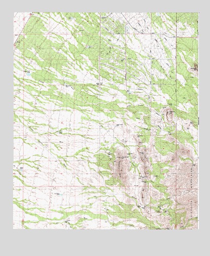
Stevens Mountain, AZ USGS Topographic Map
Click on map above to begin viewing in our Map Viewer.

This topographic map contains these locations and features:
Feature Name Type Latitude Longitude GNIS ID View Map
Aguajita WellWellN31.8851°W111.2726°515View Map
Aguinaldo MineMineN31.9190°W111.2868°519View Map
Ash CreekStreamN31.8765°W111.2834°831View Map
Banner MineMineN31.8881°W111.2859°998View Map
Black Dike MineMineN31.9323°W111.2837°1507View Map
Britten RanchLocaleN31.8876°W111.2776°1971View Map
Calera TankReservoirN31.9314°W111.3445°2368View Map
Clark MineMineN31.9062°W111.2795°2975View Map
Copper Glance MineMineN31.9354°W111.3054°3228View Map
Diamond Bell RanchPopulated PlaceN31.9734°W111.2823°25236View Map
Garambolo TankReservoirN31.9587°W111.3404°4930View Map
Gold Hill MineMineN31.8848°W111.2762°5112View Map
Hall TankReservoirN31.9541°W111.2966°5525View Map
Iron MountainSummitN31.8787°W111.2512°15405View Map
La Cholla TankReservoirN31.8951°W111.3430°6804View Map
Little Johnny MineMineN31.9295°W111.2915°31088View Map
Mollen WellWellN31.9590°W111.3168°8194View Map
Montezuma MineMineN31.9023°W111.2848°8228View Map
Philimena MineMineN31.9190°W111.3112°9366View Map
Providencia HillSummitN31.9167°W111.3023°9795View Map
Rodeo TankReservoirN31.9091°W111.3698°10469View Map
Soldier Well TankReservoirN31.9643°W111.3654°11539View Map
Stevens MountainSummitN31.9092°W111.3029°11830View Map
Stevens RanchLocaleN31.9051°W111.2887°11831View Map
Sunshine MineMineN31.8756°W111.2690°11996View Map
Tank Number FourReservoirN31.9799°W111.3246°12152View Map
Tank Number Thirty-twoReservoirN31.9963°W111.3350°15485View Map
Valencia MountainSummitN31.9426°W111.2704°13157View Map
Valencia TankReservoirN31.9472°W111.2676°13158View Map
Yellow Bird MineMineN31.9187°W111.2982°14046View Map

Note: Coordinates in the location and feature list above are referenced to NAD83 datum.


Copyright (C) 2008-2024 Ryan Niemi / Sunset Dynamics ... All Rights Reserved