TopoQuest Logo
Do you find TopoQuest useful?
Help keep TopoQuest running and adding new maps/features by donating!
Bitcoin:  19c7KJd3qBynnjoSw5npx9KScwjBe4ifkT
Litecoin:  LXs6TkuXGGXo1vDsWCkWVdjQX94eUKd6ui
Home View Maps Find Maps Find Places Resources & Links


Stilwell East, Oklahoma Topographic Map

USGS Map Title: Stilwell East, OK
USGS Map MRC: 35094G5
DRG (GeoTIFF) Download: o35094g5.tif


Neighboring USGS Topographic Map Quads:


  Christie, OK  
35094H6
 

  Westville, OK  
35094H5
 

  Lincoln, AR  
35094H4
 

  Stilwell West, OK  
35094G6
 

  Stilwell East, OK  
35094G5
 

  Evansville, AR  
35094G4
 

  Greasy, OK  
35094F6
 

  Big Round Mountain, OK  
35094F5
 

  Natural Dam, AR  
35094F4


Map MRC Location:

N36°
W95°
N36°
W94°
H8 H7 H6 H5 H4 H3 H2 H1
G8 G7 G6 G5 G4 G3 G2 G1
F8 F7 F6 F5 F4 F3 F2 F1
E8 E7 E6 E5 E4 E3 E2 E1
D8 D7 D6 D5 D4 D3 D2 D1
C8 C7 C6 C5 C4 C3 C2 C1
B8 B7 B6 B5 B4 B3 B2 B1
A8 A7 A6 A5 A4 A3 A2 A1
N35°
W95°
N35°
W94°

Stilwell East, OK USGS 1:24K Topographic Map Preview:
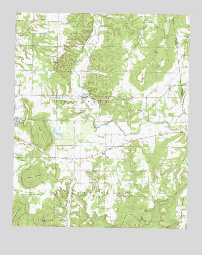
Stilwell East, OK USGS Topographic Map
Click on map above to begin viewing in our Map Viewer.

This topographic map contains these locations and features:
Feature Name Type Latitude Longitude GNIS ID View Map
Adair County JailBuildingN35.8075°W94.6247°2757801View Map
Adair County Sheriff's OfficeBuildingN35.8078°W94.6247°2757499View Map
Bell Census Designated PlaceCensusN35.7543°W94.5350°2407825View Map
Bethel ChurchChurchN35.7690°W94.5941°1090051View Map
Calvary ChurchChurchN35.8706°W94.6041°1090821View Map
Chalk Bluff CemeteryCemeteryN35.8262°W94.5769°1091193View Map
Davis MountainSummitN35.8012°W94.6044°1091955View Map
Doublehead MountainSummitN35.7570°W94.6233°1092159View Map
Elm GroveCivilN35.7843°W94.5635°2631105View Map
Elm Grove CemeteryCemeteryN35.7763°W94.5274°2712392View Map
Elm Grove Census Designated PlaceCensusN35.7925°W94.5631°2584379View Map
Elm Grove ChurchChurchN35.7768°W94.5272°1092587View Map
Ewing ChapelChurchN35.7940°W94.5599°1092677View Map
Ewing Chapel CemeteryCemeteryN35.8029°W94.5599°1092678View Map
FairfieldCivilN35.8411°W94.6123°2631107View Map
FairfieldPopulated PlaceN35.8473°W94.6124°1853467View Map
Fairfield Census Designated PlaceCensusN35.8407°W94.6062°2408103View Map
Fairfield ChurchChurchN35.8406°W94.6130°1092693View Map
Fairfield Church CemeteryCemeteryN35.8397°W94.6133°2724206View Map
Faith TabernacleChurchN35.8273°W94.5761°1092747View Map
Four Corners ChurchChurchN35.7956°W94.5586°1092983View Map
Fourkiller CemeteryCemeteryN35.8573°W94.5727°1092988View Map
Honey Hill CemeteryCemeteryN35.7672°W94.5647°2712395View Map
Honey Hill ChurchChurchN35.7681°W94.5636°1093890View Map
Killer MountainSummitN35.7606°W94.5319°1094377View Map
Muskrat MountainSummitN35.7593°W94.5433°1095721View Map
Oak Grove CemeteryCemeteryN35.8186°W94.5330°1096092View Map
Oak Grove ChurchChurchN35.8262°W94.5405°1096101View Map
Orchard DamDamN35.8051°W94.6002°1751874View Map
Orchard LakeReservoirN35.8051°W94.6002°1751875View Map
PineyCivilN35.8724°W94.5555°2631154View Map
Pleasant View ChurchChurchN35.7979°W94.6172°1096775View Map
Rock Springs ChurchChurchN35.7901°W94.5861°1097362View Map
SalemPopulated PlaceN35.7665°W94.5730°1853480View Map
SalemCivilN35.7612°W94.5755°2631165View Map
Salem Census Designated PlaceCensusN35.7612°W94.5755°2409236View Map
Soap MountainSummitN35.7534°W94.6052°1098176View Map
Stillwell Orchard PondReservoirN35.8060°W94.5963°1755772View Map
Stillwell Orchard Pond DamDamN35.8068°W94.5969°1755771View Map
Stilwell East DivisionCivilN35.7631°W94.5773°1937880View Map
Stilwell Memorial Hospital HeliportAirportN35.8168°W94.6191°1102680View Map
Taylor MountainSummitN35.7779°W94.6130°1098776View Map
Thea-Aut-La Springs CampLocaleN35.8248°W94.5449°1098841View Map
Township of StilwellCivilN35.8237°W94.5836°1824600View Map
Tri - Community Volunteer Fire DepartmentBuildingN35.7756°W94.5292°2656954View Map
United ChurchChurchN35.8259°W94.6247°1099180View Map

Note: Coordinates in the location and feature list above are referenced to NAD83 datum.


Copyright (C) 2008-2025 Ryan Niemi / Sunset Dynamics ... All Rights Reserved