TopoQuest Logo
Do you find TopoQuest useful?
Help keep TopoQuest running and adding new maps/features by donating!
Bitcoin:  19c7KJd3qBynnjoSw5npx9KScwjBe4ifkT
Litecoin:  LXs6TkuXGGXo1vDsWCkWVdjQX94eUKd6ui
Home View Maps Find Maps Find Places Resources & Links


Stone City, Colorado Topographic Map

USGS Map Title: Stone City, CO
USGS Map MRC: 38104D7
DRG (GeoTIFF) Download: o38104d7.tif


Neighboring USGS Topographic Map Quads:


  Mount Pittsburg, CO  
38104E8
 

  Timber Mountain, CO  
38104E7
 

  Buttes, CO  
38104E6
 

  Pierce Gulch, CO  
38104D8
 

  Stone City, CO  
38104D7
 

  Steele Hollow, CO  
38104D6
 

  Hobson, CO  
38104C8
 

  Swallows, CO  
38104C7
 

  Northwest Pueblo, CO  
38104C6


Map MRC Location:

N39°
W105°
N39°
W104°
H8 H7 H6 H5 H4 H3 H2 H1
G8 G7 G6 G5 G4 G3 G2 G1
F8 F7 F6 F5 F4 F3 F2 F1
E8 E7 E6 E5 E4 E3 E2 E1
D8 D7 D6 D5 D4 D3 D2 D1
C8 C7 C6 C5 C4 C3 C2 C1
B8 B7 B6 B5 B4 B3 B2 B1
A8 A7 A6 A5 A4 A3 A2 A1
N38°
W105°
N38°
W104°

Stone City, CO USGS 1:24K Topographic Map Preview:
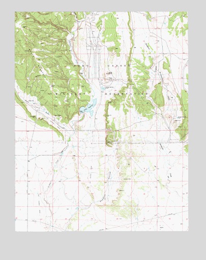
Stone City, CO USGS Topographic Map
Click on map above to begin viewing in our Map Viewer.

This topographic map contains these locations and features:
Feature Name Type Latitude Longitude GNIS ID View Map
Booth GulchValleyN38.4294°W104.8356°193881View Map
Booth MountainSummitN38.4914°W104.8694°193884View Map
Colorado School of Mines Summer CampLocaleN38.4536°W104.7639°193891View Map
Dry Creek Canyon MineMineN38.4531°W104.8589°1734093View Map
E D Freeman MineMineN38.4689°W104.8228°1734094View Map
Meadow MineMineN38.4542°W104.8405°1734095View Map
Nellie-Helen MineMineN38.4392°W104.8400°1734096View Map
Pueblo West DivisionCivilN38.4075°W104.7744°1935551View Map
Snowdon MineMineN38.4392°W104.8603°1735808View Map
Spring Canyon MinesMineN38.4531°W104.8589°1735807View Map
Stone CityPopulated PlaceN38.4486°W104.8611°193887View Map
Stone City MineMineN38.4364°W104.8586°1735809View Map
Sullivan CanyonValleyN38.4940°W104.8306°193648View Map
Teller DamDamN38.4428°W104.8266°199818View Map
Teller ReservoirReservoirN38.4452°W104.8224°193889View Map
Turkey Creek RanchLocaleN38.4194°W104.8422°193888View Map
Wands MineMineN38.4392°W104.8400°1734097View Map
White ButteSummitN38.4647°W104.8080°193885View Map
Wild Horse ParkFlatN38.4569°W104.7672°193890View Map

Note: Coordinates in the location and feature list above are referenced to NAD83 datum.


Copyright (C) 2008-2025 Ryan Niemi / Sunset Dynamics ... All Rights Reserved