TopoQuest Logo
Do you find TopoQuest useful?
Help keep TopoQuest running and adding new maps/features by donating!
Bitcoin:  19c7KJd3qBynnjoSw5npx9KScwjBe4ifkT
Litecoin:  LXs6TkuXGGXo1vDsWCkWVdjQX94eUKd6ui
Home View Maps Find Maps Find Places Resources & Links


Blanchard, Oklahoma Topographic Map

USGS Map Title: Blanchard, OK
USGS Map MRC: 35097B6
DRG (GeoTIFF) Download: o35097b6.tif


Neighboring USGS Topographic Map Quads:


  Tuttle, OK  
35097C7
 

  Oklahoma City SW, OK  
35097C6
 

  Oklahoma City SE, OK  
35097C5
 

  Chickasha NE, OK  
35097B7
 

  Blanchard, OK  
35097B6
 

  Newcastle, OK  
35097B5
 

  Tabler, OK  
35097A7
 

  Dibble, OK  
35097A6
 

  Cole, OK  
35097A5


Map MRC Location:

N36°
W98°
N36°
W97°
H8 H7 H6 H5 H4 H3 H2 H1
G8 G7 G6 G5 G4 G3 G2 G1
F8 F7 F6 F5 F4 F3 F2 F1
E8 E7 E6 E5 E4 E3 E2 E1
D8 D7 D6 D5 D4 D3 D2 D1
C8 C7 C6 C5 C4 C3 C2 C1
B8 B7 B6 B5 B4 B3 B2 B1
A8 A7 A6 A5 A4 A3 A2 A1
N35°
W98°
N35°
W97°

Blanchard, OK USGS 1:24K Topographic Map Preview:
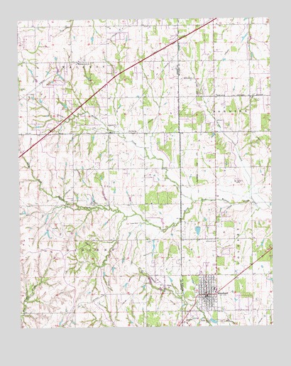
Blanchard, OK USGS Topographic Map
Click on map above to begin viewing in our Map Viewer.

This topographic map contains these locations and features:
Feature Name Type Latitude Longitude GNIS ID View Map
BlanchardPopulated PlaceN35.1378°W97.6581°1090249View Map
Blanchard CemeteryCemeteryN35.1595°W97.6511°1090250View Map
Blanchard Elementary SchoolSchoolN35.1522°W97.6568°1790563View Map
Blanchard Fire DepartmentBuildingN35.1366°W97.6594°2658281View Map
Blanchard High SchoolSchoolN35.1420°W97.6519°2712899View Map
Blanchard Intermediate Elementary SchoolSchoolN35.1399°W97.6543°2713143View Map
Blanchard Middle SchoolSchoolN35.1390°W97.6539°1790266View Map
Blanchard Police DepartmentBuildingN35.1371°W97.6592°2757663View Map
Bridge CreekPopulated PlaceN35.2351°W97.7367°1934555View Map
Bridge CreekStreamN35.1762°W97.6625°1090485View Map
Bridge Creek Elementary SchoolSchoolN35.2325°W97.7203°1090487View Map
Bridge Creek Fire DepartmentBuildingN35.2447°W97.7078°2658389View Map
Bridge Creek High SchoolSchoolN35.2357°W97.7229°1790267View Map
Bridge Creek Middle SchoolSchoolN35.2332°W97.7200°1790268View Map
Christ Chapel Freewill Baptist ChurchChurchN35.1362°W97.6586°1782549View Map
Church of ChristChurchN35.1370°W97.6611°1782550View Map
City of BlanchardCivilN35.1523°W97.6612°2409861View Map
D and G Farms Airport (historical)AirportN35.2251°W97.6464°1102582View Map
First Assembly of God ChurchChurchN35.1390°W97.6609°1782551View Map
First Baptist ChurchChurchN35.1359°W97.6573°1782552View Map
First Pentecostal ChurchChurchN35.1390°W97.6573°1782553View Map
First United Methodist ChurchChurchN35.1440°W97.6586°1782554View Map
Marantha Baptist ChurchChurchN35.2290°W97.6539°1799063View Map
McClain Grady County Emergency Medical Services District 1BuildingN35.1517°W97.6600°2695893View Map
Mission ChurchChurchN35.2040°W97.7048°1095445View Map
New Hope ChurchChurchN35.2042°W97.6912°1095814View Map
Oknoname 051013 DamDamN35.1417°W97.6853°1753666View Map
Oknoname 051013 ReservoirReservoirN35.1438°W97.6863°1753667View Map
Oknoname 051041 DamDamN35.2251°W97.7270°1753714View Map
Oknoname 051041 ReservoirReservoirN35.2272°W97.7293°1753715View Map
Oknoname 087010 DamDamN35.1651°W97.6620°1752821View Map
Oknoname 087010 ReservoirReservoirN35.1640°W97.6622°1752822View Map
Pleasant Hill Baptist ChurchChurchN35.1356°W97.6584°1782555View Map
Stinson CreekStreamN35.1726°W97.6317°1098554View Map
Town of Bridge CreekCivilN35.2306°W97.6952°2411725View Map
Township of VincentCivilN35.1584°W97.7142°1825320View Map
Township of WaldronCivilN35.2445°W97.7448°1825316View Map
Warbonnet AirportAirportN35.1679°W97.7099°1102373View Map

Note: Coordinates in the location and feature list above are referenced to NAD83 datum.


Copyright (C) 2008-2025 Ryan Niemi / Sunset Dynamics ... All Rights Reserved