TopoQuest Logo
Do you find TopoQuest useful?
Help keep TopoQuest running and adding new maps/features by donating!
Bitcoin:  19c7KJd3qBynnjoSw5npx9KScwjBe4ifkT
Litecoin:  LXs6TkuXGGXo1vDsWCkWVdjQX94eUKd6ui
Home View Maps Find Maps Find Places Resources & Links


Stowell, Texas Topographic Map

USGS Map Title: Stowell, TX
USGS Map MRC: 29094G4
DRG (GeoTIFF) Download: o29094g4.tif


Neighboring USGS Topographic Map Quads:


  Whites Bayou, TX  
29094H5
 

  Winnie NW, TX  
29094H4
 

  Fannett West, TX  
29094H3
 

  Monroe City, TX  
29094G5
 

  Stowell, TX  
29094G4
 

  Hamshire, TX  
29094G3
 

  Oyster Bayou, TX  
29094F5
 

  Stanolind Reservoir, TX  
29094F4
 

  Whites Ranch, TX  
29094F3


Map MRC Location:

N30°
W95°
N30°
W94°
H8 H7 H6 H5 H4 H3 H2 H1
G8 G7 G6 G5 G4 G3 G2 G1
F8 F7 F6 F5 F4 F3 F2 F1
E8 E7 E6 E5 E4 E3 E2 E1
D8 D7 D6 D5 D4 D3 D2 D1
C8 C7 C6 C5 C4 C3 C2 C1
B8 B7 B6 B5 B4 B3 B2 B1
A8 A7 A6 A5 A4 A3 A2 A1
N29°
W95°
N29°
W94°

Stowell, TX USGS 1:24K Topographic Map Preview:
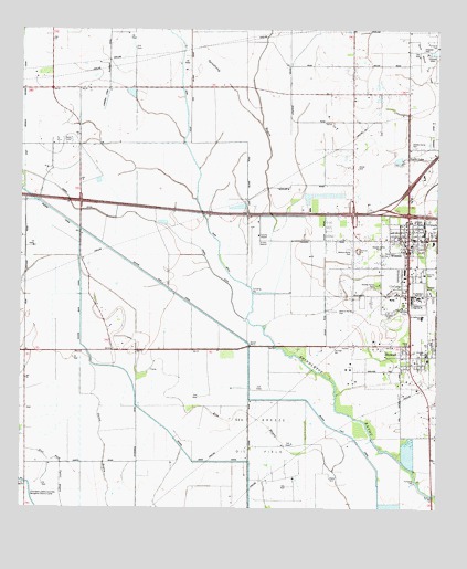
Stowell, TX USGS Topographic Map
Click on map above to begin viewing in our Map Viewer.

This topographic map contains these locations and features:
Feature Name Type Latitude Longitude GNIS ID View Map
Chambers County Constable's Office Precinct 1BuildingN29.8201°W94.3830°2751555View Map
Chambers County ParkParkN29.8097°W94.3769°2028641View Map
Chambers County-Winnie Stowell AirportAirportN29.8192°W94.4291°1384844View Map
Devers East CanalCanalN29.8033°W94.4488°1334288View Map
Fairview CemeteryCemeteryN29.8016°W94.3899°1335620View Map
FigridgePopulated PlaceN29.7630°W94.3769°1335785View Map
M and M Winnie Airport (historical)AirportN29.8513°W94.3769°1387761View Map
Marshall Estate Dam Number 1DamN29.7602°W94.3819°1862545View Map
Marshall Estate Lake Number 1ReservoirN29.7637°W94.3837°1862546View Map
Ogden DitchCanalN29.8277°W94.4777°1375261View Map
Rush DitchCanalN29.8402°W94.4482°1345760View Map
Saint Luke ChurchChurchN29.8047°W94.3885°1345990View Map
Sea Breeze Oil FieldOilfieldN29.7527°W94.4291°1346838View Map
StowellPopulated PlaceN29.7899°W94.3832°1347987View Map
Stowell Census Designated PlaceCensusN29.7814°W94.3794°2410007View Map
Stowell Post OfficePost OfficeN29.7876°W94.3836°2731357View Map
WinniePopulated PlaceN29.8202°W94.3841°1350424View Map
Winnie - Stowell Volunteer Fire DepartmentBuildingN29.8188°W94.3836°2655699View Map
Winnie Census Designated PlaceCensusN29.8167°W94.3807°2409611View Map
Winnie Community HospitalHospitalN29.8197°W94.3764°2718976View Map
Winnie Post OfficePost OfficeN29.8228°W94.3847°2731342View Map
Winnie-Stowell DivisionCivilN29.7614°W94.4210°1939331View Map

Note: Coordinates in the location and feature list above are referenced to NAD83 datum.


Copyright (C) 2008-2025 Ryan Niemi / Sunset Dynamics ... All Rights Reserved