TopoQuest Logo
Do you find TopoQuest useful?
Help keep TopoQuest running and adding new maps/features by donating!
Bitcoin:  19c7KJd3qBynnjoSw5npx9KScwjBe4ifkT
Litecoin:  LXs6TkuXGGXo1vDsWCkWVdjQX94eUKd6ui
Home View Maps Find Maps Find Places Resources & Links


Blanco, Texas Topographic Map

USGS Map Title: Blanco, TX
USGS Map MRC: 30098A4
DRG (GeoTIFF) Download: o30098a4.tif


Neighboring USGS Topographic Map Quads:


  Hye, TX  
30098B5
 

  Monument Hill, TX  
30098B4
 

  Yeager Creek, TX  
30098B3
 

  Crabapple Creek, TX  
30098A5
 

  Blanco, TX  
30098A4
 

  Payton, TX  
30098A3
 

  Kendalia, TX  
29098H5
 

  Spring Branch, TX  
29098H4
 

  Fischer, TX  
29098H3


Map MRC Location:

N31°
W99°
N31°
W98°
H8 H7 H6 H5 H4 H3 H2 H1
G8 G7 G6 G5 G4 G3 G2 G1
F8 F7 F6 F5 F4 F3 F2 F1
E8 E7 E6 E5 E4 E3 E2 E1
D8 D7 D6 D5 D4 D3 D2 D1
C8 C7 C6 C5 C4 C3 C2 C1
B8 B7 B6 B5 B4 B3 B2 B1
A8 A7 A6 A5 A4 A3 A2 A1
N30°
W99°
N30°
W98°

Blanco, TX USGS 1:24K Topographic Map Preview:
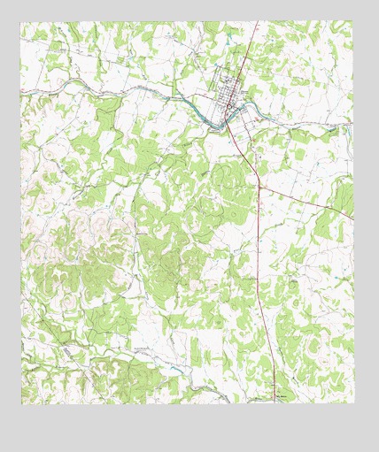
Blanco, TX USGS Topographic Map
Click on map above to begin viewing in our Map Viewer.

This topographic map contains these locations and features:
Feature Name Type Latitude Longitude GNIS ID View Map
Adrian Edwards Conn HouseBuildingN30.0966°W98.4228°2031616View Map
Beckman SpringsSpringN30.0591°W98.3936°1998611View Map
BlancoPopulated PlaceN30.0980°W98.4214°1330829View Map
Blanco CemeteryCemeteryN30.0930°W98.4170°1330830View Map
Blanco City Dam Number 1DamN30.0927°W98.4308°1857332View Map
Blanco City HallBuildingN30.0968°W98.4212°2753492View Map
Blanco City Lake Number 1ReservoirN30.0935°W98.4303°1857333View Map
Blanco County Constable's Office Precinct 4BuildingN30.0969°W98.4211°2750727View Map
Blanco DivisionCivilN30.0974°W98.3985°1938541View Map
Blanco Historic DistrictLocaleN30.0994°W98.4220°2031982View Map
Blanco Police DepartmentBuildingN30.0896°W98.4165°2750568View Map
Blanco Post OfficePost OfficeN30.0979°W98.4213°2731391View Map
Blanco State ParkParkN30.0894°W98.4239°1330832View Map
Blanco State ParkParkN30.0958°W98.4197°2028747View Map
Blanco State Park TrailTrailN30.0894°W98.4239°2033004View Map
Blanco Volunteer AmbulanceBuildingN30.0916°W98.4164°2656114View Map
Blanco Volunteer Fire DepartmentBuildingN30.0989°W98.4209°2551124View Map
Blasingame CreekStreamN30.1008°W98.4614°1372629View Map
City of BlancoCivilN30.0974°W98.4179°2409862View Map
Cottonwood CreekStreamN30.1016°W98.4686°1333456View Map
Cross Triangle Ranch AirportAirportN30.0073°W98.4256°1387656View Map
Durham BranchStreamN30.0913°W98.4014°1334802View Map
East Fork Hinds BranchStreamN30.1058°W98.4420°1334921View Map
Hereford Hills RanchLocaleN30.0180°W98.4572°1337638View Map
Hinds BranchStreamN30.0999°W98.4381°1337830View Map
Jonas CemeteryCemeteryN30.0269°W98.4267°1338827View Map
Koch BranchStreamN30.0910°W98.4275°1339206View Map
Koch SpringsSpringN30.1085°W98.4253°1998616View Map
Manahan CreekStreamN30.0133°W98.4931°1340887View Map
McKinney CemeteryCemeteryN30.1155°W98.4834°1341242View Map
McKinney CreekStreamN30.1063°W98.4775°1341244View Map
Schuetz CreekStreamN30.0094°W98.4372°1346791View Map
Soil Conservation Service Site 1 DamDamN30.1119°W98.4236°1857330View Map
Soil Conservation Service Site 1 ReservoirReservoirN30.1129°W98.4238°1857331View Map
Stubbins GapGapN30.0558°W98.4572°1348016View Map
Tatum LakeReservoirN30.1248°W98.4562°1864072View Map
Tatum Ranch AirportAirportN30.1160°W98.4613°1386257View Map
Twin SistersPopulated PlaceN30.0027°W98.4053°1379186View Map
Twin Sisters CemeteryCemeteryN30.0074°W98.4056°1348971View Map
Wayne Smith DamDamN30.1002°W98.4436°1857334View Map
Wayne Smith LakeReservoirN30.1029°W98.4526°1857335View Map
WE Four RanchLocaleN30.0399°W98.3984°1349569View Map
Wegner CemeteryCemeteryN30.0188°W98.4631°1349601View Map
West Fork Hinds BranchStreamN30.1038°W98.4409°1376698View Map

Note: Coordinates in the location and feature list above are referenced to NAD83 datum.


Copyright (C) 2008-2025 Ryan Niemi / Sunset Dynamics ... All Rights Reserved