TopoQuest Logo
Do you find TopoQuest useful?
Help keep TopoQuest running and adding new maps/features by donating!
Bitcoin:  19c7KJd3qBynnjoSw5npx9KScwjBe4ifkT
Litecoin:  LXs6TkuXGGXo1vDsWCkWVdjQX94eUKd6ui
Home View Maps Find Maps Find Places Resources & Links


Sugrue, Louisiana Topographic Map

USGS Map Title: Sugrue, LA
USGS Map MRC: 30093H1
DRG (GeoTIFF) Download: o30093h1.tif


Neighboring USGS Topographic Map Quads:


  Fort Polk, LA  
31093A2
 

  Birds Creek, LA  
31093A1
 

  Fullerton Lake, LA  
31092A8
 

  Hurricane Branch, LA  
30093H2
 

  Sugrue, LA  
30093H1
 

  Pitkin, LA  
30092H8
 

  Boneset Creek, LA  
30093G2
 

  Sugartown, LA  
30093G1
 

  Grant, LA  
30092G8


Map MRC Location:

N31°
W94°
N31°
W93°
H8 H7 H6 H5 H4 H3 H2 H1
G8 G7 G6 G5 G4 G3 G2 G1
F8 F7 F6 F5 F4 F3 F2 F1
E8 E7 E6 E5 E4 E3 E2 E1
D8 D7 D6 D5 D4 D3 D2 D1
C8 C7 C6 C5 C4 C3 C2 C1
B8 B7 B6 B5 B4 B3 B2 B1
A8 A7 A6 A5 A4 A3 A2 A1
N30°
W94°
N30°
W93°

Sugrue, LA USGS 1:24K Topographic Map Preview:
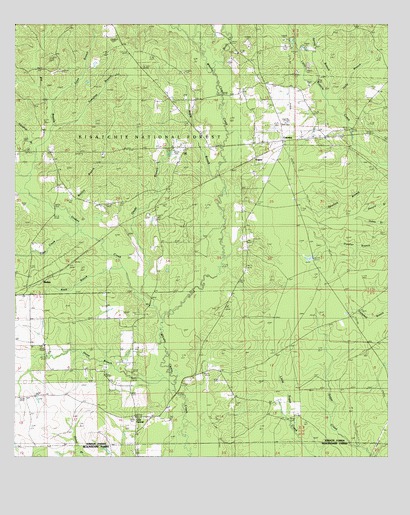
Sugrue, LA USGS Topographic Map
Click on map above to begin viewing in our Map Viewer.

This topographic map contains these locations and features:
Feature Name Type Latitude Longitude GNIS ID View Map
Big BranchStreamN30.9510°W93.1199°547075View Map
Big Branch TrailTrailN30.9835°W93.1113°548178View Map
Birds CreekStreamN30.9882°W93.0585°547091View Map
Black BranchStreamN30.9291°W93.0879°547279View Map
Cole CentralPopulated PlaceN30.8821°W93.0863°554043View Map
Coon BranchStreamN30.9777°W93.1132°547245View Map
Cowpen BranchStreamN30.9971°W93.0304°547256View Map
CravensPopulated PlaceN30.9669°W93.0352°547261View Map
Cravens Volunteer Fire DepartmentBuildingN30.9661°W93.0377°2673001View Map
Drakes CreekStreamN30.9149°W93.0752°547309View Map
Drakes Fork CemeteryCemeteryN30.9452°W93.0804°547310View Map
Fort PolkMilitaryN30.9875°W93.0500°2512473View Map
Glade BranchStreamN30.9196°W93.0813°547396View Map
Glade Branch ChurchChurchN30.9641°W93.0724°547397View Map
Grave Hill CemeteryCemeteryN30.9921°W93.0510°550012View Map
Gravel Hill ChurchChurchN30.9919°W93.0504°554599View Map
Holly BranchStreamN30.9763°W93.0182°547470View Map
Horse BranchStreamN30.8955°W93.0715°547475View Map
Lone Star ChurchChurchN30.9071°W93.1157°547621View Map
Louisiana Noname 62 DamDamN30.9685°W93.0252°556918View Map
Maple BranchStreamN30.9585°W93.0568°547646View Map
MarkeePopulated PlaceN30.9269°W93.1154°547647View Map
Marlow BranchStreamN30.9399°W93.1010°547651View Map
Marlow CemeteryCemeteryN30.9627°W93.0957°547652View Map
Marlow ChurchChurchN30.9535°W93.1113°547653View Map
Marlow Volunteer Fire DepartmentBuildingN30.9625°W93.1131°2672880View Map
Pine Grove CemeteryCemeteryN30.8902°W93.0504°550053View Map
Pine Grove United Methodist ChurchChurchN30.8902°W93.0507°555653View Map
Sassafras BranchStreamN30.9707°W93.1127°547972View Map
Slaughter BranchStreamN30.9605°W93.1202°548001View Map
Spring BranchStreamN30.9777°W93.0202°548019View Map
Spurlock BranchStreamN30.9596°W93.0007°548027View Map
SugruePopulated PlaceN30.9621°W93.0443°548047View Map
Tiger CreekStreamN30.9410°W93.1054°548085View Map
Vernon Lookout TowerTowerN30.9957°W93.0910°558837View Map
Wisby CemeteryCemeteryN30.9180°W93.0577°550094View Map
Wisby Memorial ChurchChurchN30.9182°W93.0568°548156View Map

Note: Coordinates in the location and feature list above are referenced to NAD83 datum.


Copyright (C) 2008-2025 Ryan Niemi / Sunset Dynamics ... All Rights Reserved