TopoQuest Logo
Do you find TopoQuest useful?
Help keep TopoQuest running and adding new maps/features by donating!
Bitcoin:  19c7KJd3qBynnjoSw5npx9KScwjBe4ifkT
Litecoin:  LXs6TkuXGGXo1vDsWCkWVdjQX94eUKd6ui
Home View Maps Find Maps Find Places Resources & Links


Summitville, Colorado Topographic Map

USGS Map Title: Summitville, CO
USGS Map MRC: 37106D5
DRG (GeoTIFF) Download: o37106d5.tif


Neighboring USGS Topographic Map Quads:


  Beaver Creek Reservoir, CO  
37106E6
 

  Del Norte Peak, CO  
37106E5
 

  Horseshoe Mountain, CO  
37106E4
 

  Elwood Pass, CO  
37106D6
 

  Summitville, CO  
37106D5
 

  Jasper, CO  
37106D4
 

  Summit Peak, CO  
37106C6
 

  Platoro, CO  
37106C5
 

  Red Mountain, CO  
37106C4


Map MRC Location:

N38°
W107°
N38°
W106°
H8 H7 H6 H5 H4 H3 H2 H1
G8 G7 G6 G5 G4 G3 G2 G1
F8 F7 F6 F5 F4 F3 F2 F1
E8 E7 E6 E5 E4 E3 E2 E1
D8 D7 D6 D5 D4 D3 D2 D1
C8 C7 C6 C5 C4 C3 C2 C1
B8 B7 B6 B5 B4 B3 B2 B1
A8 A7 A6 A5 A4 A3 A2 A1
N37°
W107°
N37°
W106°

Summitville, CO USGS 1:24K Topographic Map Preview:
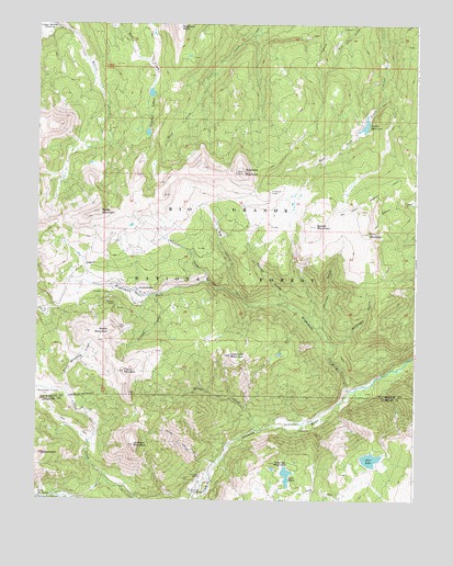
Summitville, CO USGS Topographic Map
Click on map above to begin viewing in our Map Viewer.

This topographic map contains these locations and features:
Feature Name Type Latitude Longitude GNIS ID View Map
Alum CreekStreamN37.3850°W106.5653°190599View Map
Annie MineMineN37.4247°W106.6053°1735811View Map
Asiatic MineMineN37.3914°W106.6070°1735063View Map
Aztec Tunnel MineMineN37.4206°W106.5942°1735812View Map
Beverly Shaft MineMineN37.4239°W106.5953°1735081View Map
Big HollowValleyN37.4296°W106.5605°190613View Map
Bitter CreekStreamN37.3939°W106.5500°190601View Map
Bobcat MineMineN37.4247°W106.6053°1735813View Map
Bonito MountainSummitN37.4470°W106.5331°190617View Map
Bowen PlacerMineN37.4247°W106.6053°1735073View Map
Burro MountainSummitN37.4453°W106.5161°190618View Map
Chandler TunnelMineN37.4292°W106.6012°190619View Map
Cliff MineMineN37.3820°W106.5636°1735064View Map
Cropsy CreekStreamN37.4292°W106.5853°190606View Map
Cropsy MountainSummitN37.4089°W106.5964°190603View Map
Crystal LakesReservoirN37.4770°W106.5881°190623View Map
Elephant MountainSummitN37.4131°W106.5609°190604View Map
Eurydice Shaft MineMineN37.3836°W106.5636°1735065View Map
French TunnelMineN37.4186°W106.6020°190608View Map
Fuchs DamDamN37.4736°W106.5164°199570View Map
Fuchs ReservoirReservoirN37.4736°W106.5171°190622View Map
Globe CreekStreamN37.3822°W106.5673°190591View Map
Globe MineMineN37.3775°W106.5698°1735066View Map
Golconda Group MineMineN37.4247°W106.6053°1735074View Map
Government ParkFlatN37.3953°W106.5367°190600View Map
Grayback MountainSummitN37.4617°W106.5573°190621View Map
Hutchison CorralLocaleN37.4561°W106.5484°190620View Map
Ida Tunnel MineMineN37.4283°W106.5989°1735075View Map
Iowa TunnelMineN37.4208°W106.5961°190607View Map
Kerr LakeLakeN37.3859°W106.5146°190597View Map
Lilly PondLakeN37.3816°W106.5424°190595View Map
Little Annie MineMineN37.4261°W106.5992°1735076View Map
Lookout MountainSummitN37.3897°W106.5928°190598View Map
Narrow Gauge Shaft MineMineN37.4233°W106.5978°1735077View Map
North MountainSummitN37.4508°W106.6045°190616View Map
Palmer GulchValleyN37.4269°W106.5433°190612View Map
Pass-me-by MineMineN37.3911°W106.5617°1735070View Map
Perry MineMineN37.4072°W106.5711°1735078View Map
Reynolds MineMineN37.4322°W106.5961°1735079View Map
Reynolds Tunnel MineMineN37.4242°W106.5961°1735071View Map
Sawmill CreekStreamN37.4325°W106.5692°190614View Map
SheepsheadPillarN37.3872°W106.6234°190592View Map
Smallpox GulchValleyN37.4156°W106.5270°190610View Map
South MountainSummitN37.4193°W106.6013°2664242View Map
South Mountain CreekStreamN37.4036°W106.6153°190602View Map
Stunner CabinLocaleN37.3817°W106.5711°190594View Map
Stunner CampgroundLocaleN37.3775°W106.5739°190593View Map
Summitville (historical)Populated PlaceN37.4306°W106.5923°190615View Map
Summitville MineMineN37.4361°W106.5978°1735080View Map
Summitville Tailings DamDamN37.4300°W106.5906°199598View Map
Summitville Tailings PondReservoirN37.4292°W106.5893°199599View Map
Telluride MountainSummitN37.3847°W106.5464°190596View Map
Wightman ForkStreamN37.4042°W106.5211°190605View Map
Witney GulchValleyN37.4170°W106.5290°190611View Map

Note: Coordinates in the location and feature list above are referenced to NAD83 datum.


Copyright (C) 2008-2024 Ryan Niemi / Sunset Dynamics ... All Rights Reserved