TopoQuest Logo
Do you find TopoQuest useful?
Help keep TopoQuest running and adding new maps/features by donating!
Bitcoin:  19c7KJd3qBynnjoSw5npx9KScwjBe4ifkT
Litecoin:  LXs6TkuXGGXo1vDsWCkWVdjQX94eUKd6ui
Home View Maps Find Maps Find Places Resources & Links


Sunset, Texas Topographic Map

USGS Map Title: Sunset, TX
USGS Map MRC: 33097D7
DRG (GeoTIFF) Download: o33097d7.tif


Neighboring USGS Topographic Map Quads:


  Brushy Mound, TX  
33097E8
 

  Bowie, TX  
33097E7
 

  Salona, TX  
33097E6
 

  Selma, TX  
33097D8
 

  Sunset, TX  
33097D7
 

  Smyrna, TX  
33097D6
 

  Crafton, TX  
33097C8
 

  Chico, TX  
33097C7
 

  Alvord, TX  
33097C6


Map MRC Location:

N34°
W98°
N34°
W97°
H8 H7 H6 H5 H4 H3 H2 H1
G8 G7 G6 G5 G4 G3 G2 G1
F8 F7 F6 F5 F4 F3 F2 F1
E8 E7 E6 E5 E4 E3 E2 E1
D8 D7 D6 D5 D4 D3 D2 D1
C8 C7 C6 C5 C4 C3 C2 C1
B8 B7 B6 B5 B4 B3 B2 B1
A8 A7 A6 A5 A4 A3 A2 A1
N33°
W98°
N33°
W97°

Sunset, TX USGS 1:24K Topographic Map Preview:
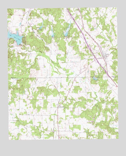
Sunset, TX USGS Topographic Map
Click on map above to begin viewing in our Map Viewer.

This topographic map contains these locations and features:
Feature Name Type Latitude Longitude GNIS ID View Map
Amon G Carter DamDamN33.4684°W97.8653°1855615View Map
Big Sandy Creek Dam Number 11DamN33.4809°W97.8395°1352127View Map
Big Sandy Creek Dam Number 12DamN33.4726°W97.8239°1352128View Map
Big Sandy Creek Dam Number 13DamN33.4729°W97.8092°1352129View Map
Carter Lake ChapelChurchN33.4843°W97.8595°1353892View Map
City of Sunset (historical)CivilN33.4526°W97.7684°2412012View Map
Cowskin CreekStreamN33.4562°W97.8356°1355239View Map
East Jones CreekStreamN33.4940°W97.8525°1356654View Map
Jones CreekStreamN33.4465°W97.8186°1360395View Map
Jones CreekStreamN33.4462°W97.8186°1383528View Map
Kiel CreekStreamN33.4632°W97.8681°1360633View Map
Middle CreekStreamN33.4407°W97.8095°1362710View Map
Park SpringsPopulated PlaceN33.4054°W97.8189°1364819View Map
Red Oak CreekStreamN33.4565°W97.8223°1366195View Map
Soil Conservation Service Site 11 DamDamN33.4801°W97.8386°1855613View Map
Soil Conservation Service Site 11 ReservoirReservoirN33.4812°W97.8379°1855614View Map
Soil Conservation Service Site 12 DamDamN33.4734°W97.8153°1855611View Map
Soil Conservation Service Site 12 ReservoirReservoirN33.4734°W97.8153°1855612View Map
Soil Conservation Service Site 13 DamDamN33.4734°W97.8086°1855609View Map
Soil Conservation Service Site 13 ReservoirReservoirN33.4752°W97.8085°1855610View Map
Soil Conservation Service Site 13a DamDamN33.4751°W97.8003°1863809View Map
Soil Conservation Service Site 13a ReservoirReservoirN33.4751°W97.8008°1863810View Map
Soil Conservation Service Site 13c DamDamN33.4568°W97.7853°1863811View Map
Soil Conservation Service Site 13c ReservoirReservoirN33.4574°W97.7860°1863812View Map
Soil Conservation Service Site 14 DamDamN33.4318°W97.7786°1857196View Map
Soil Conservation Service Site 14 ReservoirReservoirN33.4326°W97.7770°1857197View Map
Soil Conservation Service Site 8 ReservoirReservoirN33.4602°W97.8711°1855608View Map
SunsetPopulated PlaceN33.4521°W97.7667°1369410View Map
Sunset Beasley CemeteryCemeteryN33.4368°W97.7642°1369411View Map
Sunset Census Designated PlaceCensusN33.4479°W97.7664°2586993View Map
Sunset Post OfficePost OfficeN33.4519°W97.7670°2731715View Map
Sunset Volunteer Fire DepartmentBuildingN33.4531°W97.7667°2551512View Map
Tartar CemeteryCemeteryN33.4637°W97.8720°1369616View Map
Turkey CreekStreamN33.4359°W97.8075°1370228View Map
Turkey CreekStreamN33.4379°W97.8170°1383519View Map
Victory Baptist ChurchChurchN33.4440°W97.7848°2023146View Map

Note: Coordinates in the location and feature list above are referenced to NAD83 datum.


Copyright (C) 2008-2025 Ryan Niemi / Sunset Dynamics ... All Rights Reserved