TopoQuest Logo
Do you find TopoQuest useful?
Help keep TopoQuest running and adding new maps/features by donating!
Bitcoin:  19c7KJd3qBynnjoSw5npx9KScwjBe4ifkT
Litecoin:  LXs6TkuXGGXo1vDsWCkWVdjQX94eUKd6ui
Home View Maps Find Maps Find Places Resources & Links


Block Island, Rhode Island Topographic Map

USGS Map Title: Block Island, RI
USGS Map MRC: 41071B5
DRG (GeoTIFF) Download: o41071b5.tif


Neighboring USGS Topographic Map Quads:


  Quonochontaug, RI  
41071C6


  Block Island, RI  
41071B5


Map MRC Location:

N42°
W72°
N42°
W71°
H8 H7 H6 H5 H4 H3 H2 H1
G8 G7 G6 G5 G4 G3 G2 G1
F8 F7 F6 F5 F4 F3 F2 F1
E8 E7 E6 E5 E4 E3 E2 E1
D8 D7 D6 D5 D4 D3 D2 D1
C8 C7 C6 C5 C4 C3 C2 C1
B8 B7 B6 B5 B4 B3 B2 B1
A8 A7 A6 A5 A4 A3 A2 A1
N41°
W72°
N41°
W71°

Block Island, RI USGS 1:24K Topographic Map Preview:
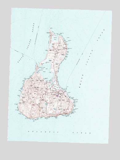
Block Island, RI USGS Topographic Map
Click on map above to begin viewing in our Map Viewer.

This topographic map contains these locations and features:
Feature Name Type Latitude Longitude GNIS ID View Map
Ambrose SwampSwampN41.1647°W71.5578°1217572View Map
Ball PondLakeN41.1727°W71.5794°1902304View Map
Ballards BeachBeachN41.1737°W71.5576°1901991View Map
Balls CoveBayN41.2101°W71.5553°1217487View Map
Balls North PointCapeN41.2129°W71.5542°1217486View Map
Balls PointCapeN41.2082°W71.5556°1219824View Map
Barlows PointCapeN41.1479°W71.5789°1217541View Map
Beach Plum HillSummitN41.2240°W71.5748°1217473View Map
Beach Plum NeckCapeN41.2232°W71.5753°1217472View Map
Beacon HillSummitN41.1757°W71.5917°1217521View Map
Beacon Hill Stone TowerTowerN41.1762°W71.5909°1902002View Map
Betty Pucky PondLakeN41.1823°W71.5839°1217513View Map
Black RockPillarN41.1440°W71.5942°1217537View Map
Black Rock BeachBeachN41.1470°W71.5953°1902007View Map
Black Rock PointCapeN41.1465°W71.5939°1217536View Map
Block IslandIslandN41.1918°W71.5745°1217555View Map
Block Island Early Learning CenterSchoolN41.1726°W71.5597°2475662View Map
Block Island Fire and Rescue StationBuildingN41.1768°W71.5710°2475209View Map
Block Island Free LibraryBuildingN41.1737°W71.5603°1902009View Map
Block Island Health Services BuildingBuildingN41.1639°W71.5616°2475208View Map
Block Island Historical Society MuseumBuildingN41.1723°W71.5623°1902010View Map
Block Island National Wildlife RefugeParkN41.2246°W71.5754°1902011View Map
Block Island North LighthouseLocaleN41.2273°W71.5762°1217466View Map
Block Island North ReefBarN41.2390°W71.5787°1219596View Map
Block Island Post OfficePost OfficeN41.1718°W71.5564°2783282View Map
Block Island SchoolSchoolN41.1648°W71.5612°1902012View Map
Block Island Southeast LighthouseLocaleN41.1526°W71.5520°1217574View Map
Block Island State AirportAirportN41.1689°W71.5795°1217560View Map
Block Island State BeachBeachN41.1823°W71.5653°1217496View Map
Bluff HeadSummitN41.1604°W71.6123°1217529View Map
Boiling SpringSpringN41.1687°W71.5537°1219382View Map
Bush Lot HillSummitN41.2157°W71.5667°1217479View Map
Cat Rock CoveBayN41.1557°W71.5459°1217548View Map
Catch PondLakeN41.1618°W71.6036°2703777View Map
Champlins DockLocaleN41.1843°W71.5817°1217502View Map
Charleston BeachBeachN41.1951°W71.5931°1217506View Map
Cherry Tree HillSummitN41.1620°W71.5931°1217530View Map
Clay HeadCliffN41.2168°W71.5553°1217484View Map
Clayhead Nature TrailTrailN41.2187°W71.5587°1902083View Map
Clayhead SwampLakeN41.2063°W71.5594°1217488View Map
Continental PondLakeN41.1680°W71.5595°1217569View Map
Coonimus SwampSwampN41.1659°W71.6089°1217527View Map
Cormorant CoveBayN41.1904°W71.5898°1217504View Map
Cormorant PointCapeN41.1912°W71.5881°1217503View Map
Corn CoveBayN41.1512°W71.5564°1217544View Map
Corn NeckCapeN41.2134°W71.5639°1217478View Map
Cow CoveBayN41.2268°W71.5720°1217467View Map
Crescent BeachBeachN41.1912°W71.5634°1217495View Map
Deep PondLakeN41.1594°W71.5947°1217531View Map
Dees Tug HoleLakeN41.2005°W71.5658°1902116View Map
Dickens PointCapeN41.1512°W71.6092°1217533View Map
Dories CoveBayN41.1737°W71.6078°1217522View Map
Dunn LandingPopulated PlaceN41.1815°W71.6064°1219501View Map
Fort IslandIslandN41.1787°W71.5720°1217517View Map
Franklin SwampSwampN41.1689°W71.6071°1217526View Map
Free Will Baptist ChurchChurchN41.1687°W71.6014°1902166View Map
Fresh PondLakeN41.1606°W71.5787°1217559View Map
Fresh SwampSwampN41.1621°W71.5728°1217561View Map
Garden PondLakeN41.2093°W71.5680°1217481View Map
Georgian SwampLakeN41.1984°W71.5692°1217491View Map
Governor Gorton FarmLocaleN41.2120°W71.5684°1217477View Map
Grace CoveBayN41.1870°W71.5973°1217507View Map
Grace PointCapeN41.1829°W71.6051°1217508View Map
Great PointCapeN41.1487°W71.5659°1217543View Map
Great Salt PondBayN41.1920°W71.5820°1217500View Map
Great SwampSwampN41.1662°W71.5685°1217566View Map
Green Hill CoveBayN41.1632°W71.5445°1217551View Map
Grove PointCapeN41.2257°W71.5659°1217468View Map
Grove Point RockPillarN41.2268°W71.5639°1217469View Map
Gunners HillSummitN41.1982°W71.5873°1217499View Map
Harbor ChurchChurchN41.1716°W71.5570°1902145View Map
Harbor HillSummitN41.1640°W71.5537°1219827View Map
Harbor NeckCapeN41.1940°W71.5914°1217505View Map
Harbor PondBayN41.1770°W71.5662°1217518View Map
Harris PointCapeN41.1907°W71.5737°1217501View Map
Indian Head NeckCapeN41.1879°W71.5687°1217494View Map
Isaacs CornerPopulated PlaceN41.1643°W71.5801°1219503View Map
Isaiahs GullyBayN41.2204°W71.5587°1217482View Map
Island CemeteryCemeteryN41.1787°W71.5817°1219825View Map
Jerrys PointCapeN41.2037°W71.5581°1217490View Map
Jobs HillSummitN41.1820°W71.5776°1217511View Map
John E's PondLakeN41.1558°W71.5597°1217571View Map
John R Dodge CemeteryCemeteryN41.1663°W71.5964°1219826View Map
Lantern RockPillarN41.1718°W71.5517°1217553View Map
Lewis PointCapeN41.1473°W71.5995°1217534View Map
Lighthouse CoveBayN41.1512°W71.5523°1217545View Map
Little Sachem PondLakeN41.2138°W71.5600°1217485View Map
Logwood CoveBayN41.2212°W71.5773°1217471View Map
Long Lot PondLakeN41.2118°W71.5665°1217480View Map
Mansion BeachBeachN41.2015°W71.5598°1217492View Map
Martins PointCapeN41.1718°W71.6101°1217524View Map
Middle PondLakeN41.2158°W71.5747°1219994View Map
Middletown SquareParkN41.1718°W71.5781°1902295View Map
Mill PondLakeN41.1721°W71.5648°1217567View Map
Mill Tail SwampSwampN41.1690°W71.5639°1217568View Map
Mill Tail Swamp and PondReservoirN41.1690°W71.5646°1219035View Map
Mitchell PondLakeN41.1526°W71.5828°1217557View Map
Mohegan BluffsCliffN41.1518°W71.5567°1219828View Map
Monhegan Bluffs BeachBeachN41.1509°W71.5601°1902303View Map
Mouwneit HillSummitN41.1718°W71.5942°1217523View Map
Neptune Lodge Number 21BuildingN41.1737°W71.5589°1902327View Map
New HarborBayN41.1829°W71.5734°1217510View Map
New Meadow Hill SwampSwampN41.1727°W71.5724°1217564View Map
New ShorehamPopulated PlaceN41.1723°W71.5578°1219853View Map
New Shoreham Census Designated PlaceCensusN41.1742°W71.5702°2631338View Map
New Shoreham CenterPopulated PlaceN41.1715°W71.5773°1219850View Map
New Shoreham Police DepartmentBuildingN41.1769°W71.5709°2475374View Map
New Shoreham Town HallBuildingN41.1726°W71.5626°1902330View Map
Niles SpringSpringN41.2309°W71.5717°1902333View Map
Niles SwampSwampN41.2144°W71.5727°1217474View Map
North Light Interpretive CenterBuildingN41.2293°W71.5778°1904529View Map
North Ligth BeachBeachN41.2301°W71.5753°1904528View Map
Old Breach CutBayN41.1995°W71.5820°1217498View Map
Old Briton RockPillarN41.2207°W71.5534°1217483View Map
Old Center School HouseSchoolN41.1723°W71.5626°1902356View Map
Old HarborHarborN41.1745°W71.5564°1217554View Map
Old Harbor (historical)LocaleN41.1737°W71.5576°1902359View Map
Old Harbor Historic DistrictParkN41.1723°W71.5576°1902360View Map
Old Harbor LandingPopulated PlaceN41.1662°W71.5487°1219502View Map
Old Harbor PointCapeN41.1648°W71.5442°1217552View Map
Old Whale RockPillarN41.1573°W71.5423°1217549View Map
Payne PondLakeN41.1578°W71.5559°1217573View Map
Pebbly BeachBeachN41.1668°W71.5509°1219364View Map
Peckham PondLakeN41.1561°W71.5811°1217558View Map
Pilot HillSummitN41.1576°W71.5628°1217570View Map
Plover HillSummitN41.1501°W71.5953°1217535View Map
Primitive Methodist ChurchChurchN41.1732°W71.5784°1902408View Map
Rat IslandIslandN41.1795°W71.5717°1217519View Map
Rodman HollowValleyN41.1487°W71.5867°1217556View Map
Rodman PondLakeN41.1822°W71.5882°1217514View Map
Roiles HarborBayN41.2059°W71.5570°1217489View Map
Rossis SwampSwampN41.1724°W71.5763°1902450View Map
Sachem PondLakeN41.2225°W71.5697°1217470View Map
Sand Bank CoveBayN41.1532°W71.5481°1217546View Map
Sands PondLakeN41.1562°W71.5676°1217563View Map
Sandy HillSummitN41.1840°W71.5989°1217509View Map
Sandy PointCapeN41.2326°W71.5776°1217465View Map
Schooner PointCapeN41.1537°W71.6126°1217532View Map
Scotch BeachBeachN41.1932°W71.5639°1217493View Map
Settlers RockBarN41.2251°W71.5614°1902492View Map
Sheffield CemeteryCemeteryN41.2099°W71.5704°1219823View Map
Siahs SwampLakeN41.1826°W71.5981°1217512View Map
Skippers IslandIslandN41.2009°W71.5773°1217497View Map
Snores RocksPillarN41.2107°W71.5792°1217475View Map
Southeast PointCapeN41.1543°W71.5462°1217547View Map
Southwest PointCapeN41.1598°W71.6134°1217528View Map
Spar PointCapeN41.1482°W71.5845°1217540View Map
Split Rock CoveBayN41.1468°W71.5912°1217538View Map
Spring House Ice PondLakeN41.1690°W71.5536°1902535View Map
Stevens CoveBayN41.1676°W71.6114°1217525View Map
Sugarloaf CoveBayN41.2144°W71.5542°2575320View Map
Sunset HillSummitN41.1687°W71.5698°1217565View Map
Swede HillSummitN41.1770°W71.5989°1217520View Map
The PlainsAreaN41.1576°W71.5545°1217562View Map
Tilson CoveBayN41.1595°W71.5442°1217550View Map
Toms PointCapeN41.1473°W71.5892°1217539View Map
Town of New ShorehamCivilN41.1881°W71.5749°1220043View Map
Trims PondBayN41.1798°W71.5717°1217516View Map
United States Weather Bureau StationLocaleN41.1786°W71.5708°2475181View Map
Vaills BeachBeachN41.1487°W71.5723°1217542View Map
Veterans ParkParkN41.1804°W71.5778°1217515View Map
Wash PondLakeN41.2111°W71.5754°1217476View Map
West BeachBeachN41.2218°W71.5764°1902596View Map
West Side Life Saving StationLocaleN41.1640°W71.6101°1902599View Map
Woonsocket HouseBuildingN41.1723°W71.5623°1902644View Map
Worden PondLakeN41.1602°W71.6058°1219500View Map

Note: Coordinates in the location and feature list above are referenced to NAD83 datum.


Copyright (C) 2008-2025 Ryan Niemi / Sunset Dynamics ... All Rights Reserved