TopoQuest Logo
Do you find TopoQuest useful?
Help keep TopoQuest running and adding new maps/features by donating!
Bitcoin:  19c7KJd3qBynnjoSw5npx9KScwjBe4ifkT
Litecoin:  LXs6TkuXGGXo1vDsWCkWVdjQX94eUKd6ui
Home View Maps Find Maps Find Places Resources & Links


Tecopa, California Topographic Map

USGS Map Title: Tecopa, CA
USGS Map MRC: 35116G2
DRG (GeoTIFF) Download: o35116g2.tif


Neighboring USGS Topographic Map Quads:


  Shoshone, CA  
35116H3
 

  Resting Spring, CA  
35116H2
 

  North of Tecopa Pass, CA  
35116H1
 

  Ibex Pass, CA  
35116G3
 

  Tecopa, CA  
35116G2
 

  Tecopa Pass, CA  
35116G1
 

  Saddle Peak Hills, CA  
35116F3
 

  Dumont Dunes, CA  
35116F2
 

  Valjean Hills, CA  
35116F1


Map MRC Location:

N36°
W117°
N36°
W116°
H8 H7 H6 H5 H4 H3 H2 H1
G8 G7 G6 G5 G4 G3 G2 G1
F8 F7 F6 F5 F4 F3 F2 F1
E8 E7 E6 E5 E4 E3 E2 E1
D8 D7 D6 D5 D4 D3 D2 D1
C8 C7 C6 C5 C4 C3 C2 C1
B8 B7 B6 B5 B4 B3 B2 B1
A8 A7 A6 A5 A4 A3 A2 A1
N35°
W117°
N35°
W116°

Tecopa, CA USGS 1:24K Topographic Map Preview:
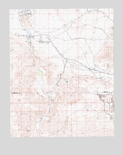
Tecopa, CA USGS Topographic Map
Click on map above to begin viewing in our Map Viewer.

This topographic map contains these locations and features:
Feature Name Type Latitude Longitude GNIS ID View Map
Acme (historical)Populated PlaceN35.7869°W116.2009°1666876View Map
Acme MineMineN35.7680°W116.1286°1666877View Map
Amargosa Canyon Natural Area ACECParkN35.7896°W116.1619°2356530View Map
Chicago ValleyValleyN35.8605°W116.1334°240532View Map
China RanchLocaleN35.8011°W116.1950°240557View Map
Desert Bard MineMineN35.8069°W116.1420°1666822View Map
Dumont CrossingCrossingN35.7568°W116.2194°2363269View Map
Grimshaw LakeLakeN35.8544°W116.2307°243042View Map
Gunsight MineMineN35.8489°W116.1253°243089View Map
Long ValleyValleyN35.8161°W116.2176°2356531View Map
Southern Inyo Fire Protection DistrictBuildingN35.8709°W116.2325°2624024View Map
Sperry HillsRangeN35.7841°W116.2395°254289View Map
Sperry Trestle (historical)BridgeN35.7751°W116.2010°2356536View Map
TecopaPopulated PlaceN35.8483°W116.2264°250293View Map
Tecopa Census Designated PlaceCensusN35.8352°W116.2076°2410062View Map
Tecopa HillsRangeN35.8658°W116.2297°254325View Map
Tecopa Hot SpringsSpringN35.8734°W116.2289°250294View Map
Tecopa Hot Springs County ParkParkN35.8714°W116.2372°1666831View Map
Tecopa Post OfficePost OfficeN35.8485°W116.2276°2783784View Map
Tecopa WashStreamN35.8347°W116.2245°1666833View Map
The BowlBasinN35.8143°W116.2126°2356532View Map
The MeadowsFlatN35.8042°W116.2121°2356533View Map
The NarrowsGapN35.7696°W116.2078°2356537View Map
The PalisadesCliffN35.7792°W116.1998°2356535View Map
Western Talc MineMineN35.7805°W116.1259°251399View Map
Willow SpringSpringN35.8050°W116.1856°251639View Map

Note: Coordinates in the location and feature list above are referenced to NAD83 datum.


Copyright (C) 2008-2025 Ryan Niemi / Sunset Dynamics ... All Rights Reserved