TopoQuest Logo
Do you find TopoQuest useful?
Help keep TopoQuest running and adding new maps/features by donating!
Bitcoin:  19c7KJd3qBynnjoSw5npx9KScwjBe4ifkT
Litecoin:  LXs6TkuXGGXo1vDsWCkWVdjQX94eUKd6ui
Home View Maps Find Maps Find Places Resources & Links


Tee Pee City, Texas Topographic Map

USGS Map Title: Tee Pee City, TX
USGS Map MRC: 34100A5
DRG (GeoTIFF) Download: o34100a5.tif


Neighboring USGS Topographic Map Quads:


  Turtle Hole Camp, TX  
34100B6
 

  Fields Canyon, TX  
34100B5
 

  Cee Vee, TX  
34100B4
 

  Ballard Camp, TX  
34100A6
 

  Tee Pee City, TX  
34100A5
 

  Devils Canyon, TX  
34100A4
 

  Russellville, TX  
33100H6
 

  China Canyon, TX  
33100H5
 

  Grow NW, TX  
33100H4


Map MRC Location:

N35°
W101°
N35°
W100°
H8 H7 H6 H5 H4 H3 H2 H1
G8 G7 G6 G5 G4 G3 G2 G1
F8 F7 F6 F5 F4 F3 F2 F1
E8 E7 E6 E5 E4 E3 E2 E1
D8 D7 D6 D5 D4 D3 D2 D1
C8 C7 C6 C5 C4 C3 C2 C1
B8 B7 B6 B5 B4 B3 B2 B1
A8 A7 A6 A5 A4 A3 A2 A1
N34°
W101°
N34°
W100°

Tee Pee City, TX USGS 1:24K Topographic Map Preview:
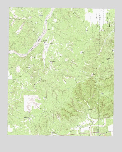
Tee Pee City, TX USGS Topographic Map
Click on map above to begin viewing in our Map Viewer.

This topographic map contains these locations and features:
Feature Name Type Latitude Longitude GNIS ID View Map
Bluff CreekStreamN34.0104°W100.5265°1352515View Map
Bluff Creek TankReservoirN34.0094°W100.5393°1352520View Map
Bluff Creek WindmillLocaleN34.0029°W100.5723°1352521View Map
Bull Pasture HillSummitN34.0287°W100.5093°1353248View Map
Cow Hollow TankReservoirN34.0608°W100.5255°1355210View Map
Cow Hollow TrapReservoirN34.0759°W100.5096°1355211View Map
Cow Pasture TankReservoirN34.0720°W100.5748°1355214View Map
Cow Pasture WindmillLocaleN34.0259°W100.5301°1355217View Map
Cutting Flat WindmillLocaleN34.1170°W100.5896°1355508View Map
Dave Harris WindmillLocaleN34.0229°W100.5826°1355664View Map
Divide WindmillLocaleN34.0415°W100.5143°1356059View Map
Fiftythree WindmillLocaleN34.0415°W100.6232°1357325View Map
Humpy TankReservoirN34.0373°W100.5825°1359829View Map
Lone Pole WindmillLocaleN34.0815°W100.5390°1361659View Map
Moore WindmillLocaleN34.0656°W100.6193°1363121View Map
New TankReservoirN34.0197°W100.5967°1363797View Map
Old Headquarters TankReservoirN34.0158°W100.5995°1364432View Map
Red HillsSummitN34.0898°W100.5023°1375674View Map
Red Hills TankReservoirN34.0839°W100.5010°1366168View Map
Sand WindmillLocaleN34.1029°W100.5343°1367664View Map
Schweitzer WindmillLocaleN34.0659°W100.6010°1367863View Map
South Trap WindmillLocaleN34.0751°W100.5732°1368788View Map
Sunday Morning WindmillLocaleN34.0142°W100.5282°1369396View Map
Tee Pee CityLocaleN34.0920°W100.5840°1369679View Map
Tee Pee City CemeteryCemeteryN34.0609°W100.6068°2773397View Map
Tee Pee City WindmillLocaleN34.0892°W100.5762°1369680View Map
Tee Pee CreekStreamN34.1137°W100.5807°1376405View Map
The DitchStreamN34.1076°W100.5843°1369777View Map

Note: Coordinates in the location and feature list above are referenced to NAD83 datum.


Copyright (C) 2008-2025 Ryan Niemi / Sunset Dynamics ... All Rights Reserved