TopoQuest Logo
Do you find TopoQuest useful?
Help keep TopoQuest running and adding new maps/features by donating!
Bitcoin:  19c7KJd3qBynnjoSw5npx9KScwjBe4ifkT
Litecoin:  LXs6TkuXGGXo1vDsWCkWVdjQX94eUKd6ui
Home View Maps Find Maps Find Places Resources & Links


Tetilla Peak, New Mexico Topographic Map

USGS Map Title: Tetilla Peak, NM
USGS Map MRC: 35106E2
DRG (GeoTIFF) Download: o35106e2.tif


Neighboring USGS Topographic Map Quads:


  Cochiti Dam, NM  
35106F3
 

  Montoso Peak, NM  
35106F2
 

  Agua Fria, NM  
35106F1
 

  Santo Domingo Pueblo, NM  
35106E3
 

  Tetilla Peak, NM  
35106E2
 

  Turquoise Hill, NM  
35106E1
 

  San Felipe Pueblo NE, NM  
35106D3
 

  Madrid, NM  
35106D2
 

  Picture Rock, NM  
35106D1


Map MRC Location:

N36°
W107°
N36°
W106°
H8 H7 H6 H5 H4 H3 H2 H1
G8 G7 G6 G5 G4 G3 G2 G1
F8 F7 F6 F5 F4 F3 F2 F1
E8 E7 E6 E5 E4 E3 E2 E1
D8 D7 D6 D5 D4 D3 D2 D1
C8 C7 C6 C5 C4 C3 C2 C1
B8 B7 B6 B5 B4 B3 B2 B1
A8 A7 A6 A5 A4 A3 A2 A1
N35°
W107°
N35°
W106°

Tetilla Peak, NM USGS 1:24K Topographic Map Preview:
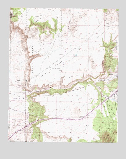
Tetilla Peak, NM USGS Topographic Map
Click on map above to begin viewing in our Map Viewer.

This topographic map contains these locations and features:
Feature Name Type Latitude Longitude GNIS ID View Map
10095 Water WellWellN35.5067°W106.1678°926837View Map
267 Waldo InterchangeCrossingN35.5209°W106.1806°924737View Map
Alamo CreekStreamN35.5578°W106.1511°903044View Map
Arroyo YupaArroyoN35.5453°W106.1439°918073View Map
Caņada de Santa FeValleyN35.5509°W106.2389°918098View Map
CaņonLocaleN35.5798°W106.1361°904503View Map
Cerro BonanzaSummitN35.5048°W106.1372°918135View Map
Cerro SeguroSummitN35.5703°W106.1375°918150View Map
Cienega CreekStreamN35.5564°W106.1506°905153View Map
Cienega SchoolSchoolN35.5625°W106.1253°887602View Map
Cieneguilla Pueblo Historic SiteLocaleN35.5628°W106.1309°933789View Map
Cochiti WellReservoirN35.5934°W106.2400°912992View Map
Cochiti WellWellN35.5936°W106.2409°916013View Map
Eight Hundred Foot WellWellN35.5686°W106.1975°906023View Map
Evelyn MineMineN35.5117°W106.1264°917132View Map
Falda del MonteSlopeN35.5134°W106.1339°937186View Map
Gold and Turquoise Historical MarkerParkN35.5689°W106.2003°931687View Map
Hiser-Moore ClaimsMineN35.5445°W106.2167°917657View Map
Juanita Lopez CreekStreamN35.5436°W106.1395°907477View Map
La BajadaPopulated PlaceN35.5561°W106.2409°928746View Map
La Bajada CemeteryCemeteryN35.5561°W106.2408°931211View Map
La Bajada HillSlopeN35.5578°W106.2297°918213View Map
La Bajada Historical MarkerParkN35.5578°W106.2297°931682View Map
La Bajada Historical MarkerParkN35.5689°W106.2003°931702View Map
La Bajada InterchangeCrossingN35.5150°W106.2256°924611View Map
La Bajada MesaBenchN35.5689°W106.2003°918214View Map
La Bajada Mesa Agricultural SiteLocaleN35.5689°W106.2003°934258View Map
La Bajada MineMineN35.5492°W106.2078°907603View Map
La Bajada Post Office (historical)Post OfficeN35.5561°W106.2409°938118View Map
La CienegaPopulated PlaceN35.5628°W106.1309°918216View Map
La CienegaMineN35.5734°W106.1306°916460View Map
La Cienega Post Office (historical)Post OfficeN35.5628°W106.1309°938157View Map
La Cienega Volunteer Fire Department Station 2BuildingN35.5629°W106.1251°2657731View Map
La Cieniga ScoriaMineN35.6109°W106.1361°917955View Map
La MajadaMineN35.5575°W106.1684°916826View Map
Las Golondrinas Ranch Site and Acequia SystemLocaleN35.5628°W106.1309°935756View Map
Las TetillitasSummitN35.5756°W106.1547°918228View Map
Lone Star MineMineN35.5492°W106.2081°916860View Map
RG-13743 Water WellWellN35.5617°W106.1334°922610View Map
RG-16860 Water WellWellN35.5603°W106.1347°922609View Map
RG-18706 Water WellWellN35.5923°W106.1259°925569View Map
RG-22606 Water WellWellN35.5586°W106.1336°926847View Map
RG-22771 Water WellWellN35.5864°W106.1297°925568View Map
RG-23362 Water WellWellN35.5661°W106.1270°922611View Map
RG-24679 Water WellWellN35.5403°W106.1364°922616View Map
RG-30067 Water WellWellN35.6181°W106.1389°922603View Map
RG-3869 Water WellWellN35.5661°W106.1270°922608View Map
RG-4050 Water WellWellN35.5561°W106.1361°926846View Map
RG-7308 Water WellWellN35.5386°W106.1259°922615View Map
RG-7373 Water WellWellN35.5992°W106.1250°925941View Map
RG-8247 Water WellWellN35.5661°W106.1270°922612View Map
Rim WellReservoirN35.5853°W106.2200°912990View Map
Section Twenty-Eight TankReservoirN35.5917°W106.2031°912993View Map
Sito de Juana Lopez GrantCivilN35.5339°W106.1356°918369View Map
South End of the Rockies Historical MarkerParkN35.5689°W106.2003°931705View Map
Tetilla PeakSummitN35.6081°W106.2097°928826View Map
Tetilla Trick TantReservoirN35.5817°W106.2064°912989View Map
Thompson 1 Water WellWellN35.5442°W106.1450°922617View Map
Trio ClaimMineN35.5114°W106.1314°914578View Map
Tsinat MesaBenchN35.5620°W106.1759°911842View Map
Tsinat RuinsLocaleN35.5550°W106.1945°911843View Map
Turquoise Trading Post (historical)LocaleN35.5464°W106.1284°918390View Map

Note: Coordinates in the location and feature list above are referenced to NAD83 datum.


Copyright (C) 2008-2024 Ryan Niemi / Sunset Dynamics ... All Rights Reserved