TopoQuest Logo
Do you find TopoQuest useful?
Help keep TopoQuest running and adding new maps/features by donating!
Bitcoin:  19c7KJd3qBynnjoSw5npx9KScwjBe4ifkT
Litecoin:  LXs6TkuXGGXo1vDsWCkWVdjQX94eUKd6ui
Home View Maps Find Maps Find Places Resources & Links


Teton Village, Wyoming Topographic Map

USGS Map Title: Teton Village, WY
USGS Map MRC: 43110E7
DRG (GeoTIFF) Download: o43110e7.tif


Neighboring USGS Topographic Map Quads:


  Mount Bannon, WY  
43110F8
 

  Grand Teton, WY  
43110F7
 

  Moose, WY  
43110F6
 

  Rendezvous Peak, WY  
43110E8
 

  Teton Village, WY  
43110E7
 

  Gros Ventre Junction, WY  
43110E6
 

  Teton Pass, WY  
43110D8
 

  Jackson, WY  
43110D7
 

  Cache Creek, WY  
43110D6


Map MRC Location:

N44°
W111°
N44°
W110°
H8 H7 H6 H5 H4 H3 H2 H1
G8 G7 G6 G5 G4 G3 G2 G1
F8 F7 F6 F5 F4 F3 F2 F1
E8 E7 E6 E5 E4 E3 E2 E1
D8 D7 D6 D5 D4 D3 D2 D1
C8 C7 C6 C5 C4 C3 C2 C1
B8 B7 B6 B5 B4 B3 B2 B1
A8 A7 A6 A5 A4 A3 A2 A1
N43°
W111°
N43°
W110°

Teton Village, WY USGS 1:24K Topographic Map Preview:
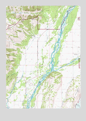
Teton Village, WY USGS Topographic Map
Click on map above to begin viewing in our Map Viewer.

This topographic map contains these locations and features:
Feature Name Type Latitude Longitude GNIS ID View Map
Anchor RanchLocaleN43.5266°W110.8619°1604766View Map
Apres Vous PeakSummitN43.6089°W110.8311°1597790View Map
Aspen RanchLocaleN43.5938°W110.7958°1604764View Map
Granite CanyonValleyN43.6169°W110.8124°1600020View Map
Granite Canyon TrailTrailN43.6158°W110.8274°1600021View Map
Granite CreekStreamN43.5791°W110.8074°1600023View Map
Gros Ventre RiverStreamN43.5452°W110.7991°1600117View Map
Jackson Hole Country ClubLocaleN43.5658°W110.7558°1605317View Map
Jackson Hole Fire and Emergency Medical Services Station 6 Teton PinesBuildingN43.5164°W110.8427°2673496View Map
Jackson Hole Ski AreaLocaleN43.5966°W110.8474°1600577View Map
Jensen CanyonValleyN43.5536°W110.8553°1600605View Map
Lake CreekStreamN43.5346°W110.8516°1600788View Map
Moose Creek RanchLocaleN43.5541°W110.8563°1604765View Map
Moose Wilson RoadPopulated PlaceN43.5252°W110.8447°1853207View Map
Moose Wilson Road Census Designated PlaceCensusN43.5315°W110.8340°2408865View Map
Phillips CanyonValleyN43.5425°W110.8569°1602118View Map
Rock Springs CanyonValleyN43.5783°W110.8525°1602602View Map
Spring GulchValleyN43.5311°W110.7696°1603283View Map
Teton VillagePopulated PlaceN43.5880°W110.8280°1603585View Map
Teton Village Census Designated PlaceCensusN43.5931°W110.8441°2410072View Map
Teton Village Post OfficePost OfficeN43.5859°W110.8266°2767858View Map
Teton Village Special Fire DistrictBuildingN43.5909°W110.8260°2673611View Map
West Gros Ventre ButteSummitN43.5368°W110.7997°1604087View Map

Note: Coordinates in the location and feature list above are referenced to NAD83 datum.


Copyright (C) 2008-2024 Ryan Niemi / Sunset Dynamics ... All Rights Reserved