TopoQuest Logo
Do you find TopoQuest useful?
Help keep TopoQuest running and adding new maps/features by donating!
Bitcoin:  19c7KJd3qBynnjoSw5npx9KScwjBe4ifkT
Litecoin:  LXs6TkuXGGXo1vDsWCkWVdjQX94eUKd6ui
Home View Maps Find Maps Find Places Resources & Links


The Horns, Maine Topographic Map

USGS Map Title: The Horns, ME
USGS Map MRC: 45070B3
DRG (GeoTIFF) Download: o45070b3.tif


Neighboring USGS Topographic Map Quads:


  King And Bartlett Mountain, ME  
45070C4
 

  King And Bartlett Lake, ME  
45070C3
 

  Basin Mountain, ME  
45070C2
 

  Stratton, ME  
45070B4
 

  The Horns, ME  
45070B3
 

  Little Bigelow Mountain, ME  
45070B2
 

  Black Nubble, ME  
45070A4
 

  Sugarloaf Mountain, ME  
45070A3
 

  Poplar Mountain, ME  
45070A2


Map MRC Location:

N46°
W71°
N46°
W70°
H8 H7 H6 H5 H4 H3 H2 H1
G8 G7 G6 G5 G4 G3 G2 G1
F8 F7 F6 F5 F4 F3 F2 F1
E8 E7 E6 E5 E4 E3 E2 E1
D8 D7 D6 D5 D4 D3 D2 D1
C8 C7 C6 C5 C4 C3 C2 C1
B8 B7 B6 B5 B4 B3 B2 B1
A8 A7 A6 A5 A4 A3 A2 A1
N45°
W71°
N45°
W70°

The Horns, ME USGS 1:24K Topographic Map Preview:
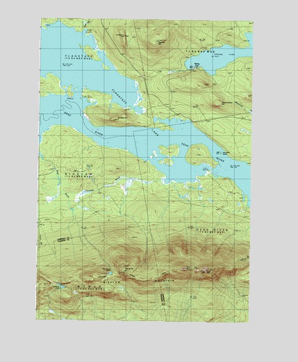
The Horns, ME USGS Topographic Map
Click on map above to begin viewing in our Map Viewer.

This topographic map contains these locations and features:
Feature Name Type Latitude Longitude GNIS ID View Map
Avery PeakSummitN45.1466°W70.2759°572033View Map
Becky InletStreamN45.2453°W70.3534°561975View Map
Bigelow Lookout TowerTowerN45.1464°W70.2776°581562View Map
Bigelow TownshipCivilN45.1851°W70.3654°1987396View Map
Cranberry PondLakeN45.1390°W70.3601°564476View Map
Fire Warden TrailTrailN45.1320°W70.3015°566163View Map
Flagstaff LakeReservoirN45.1978°W70.3067°566271View Map
Flagstaff MountainSummitN45.2411°W70.3063°566273View Map
Hurricane BrookStreamN45.1845°W70.3006°568499View Map
Hurricane IslandIslandN45.1953°W70.2690°578879View Map
Jim Eaton HillSummitN45.2084°W70.3310°578878View Map
Limestone HillSummitN45.2430°W70.3252°569591View Map
Mount BigelowSummitN45.1473°W70.2892°562253View Map
Parsons BrookStreamN45.1745°W70.2517°581975View Map
Picked Chicken HillSummitN45.2154°W70.2706°573280View Map
Spring LakeLakeN45.2363°W70.2645°576108View Map
Spring LakePopulated PlaceN45.2301°W70.2845°576109View Map
The HornsSummitN45.1450°W70.3232°576827View Map
The Horns PondLakeN45.1447°W70.3315°576828View Map
Unorganized Territory of WymanCivilN45.1289°W70.3553°582830View Map
Usher InletStreamN45.2487°W70.3690°577676View Map
West PeakSummitN45.1468°W70.2883°578186View Map

Note: Coordinates in the location and feature list above are referenced to NAD83 datum.


Copyright (C) 2008-2024 Ryan Niemi / Sunset Dynamics ... All Rights Reserved