TopoQuest Logo
Do you find TopoQuest useful?
Help keep TopoQuest running and adding new maps/features by donating!
Bitcoin:  19c7KJd3qBynnjoSw5npx9KScwjBe4ifkT
Litecoin:  LXs6TkuXGGXo1vDsWCkWVdjQX94eUKd6ui
Home View Maps Find Maps Find Places Resources & Links


Thermopolis, Wyoming Topographic Map

USGS Map Title: Thermopolis, WY
USGS Map MRC: 43108F2
DRG (GeoTIFF) Download: o43108f2.tif


Neighboring USGS Topographic Map Quads:


  Little Sand Draw, WY  
43108G3
 

  Kirby, WY  
43108G2
 

  Cedar Mountain, WY  
43108G1
 

  Rattlesnake Gulch, WY  
43108F3
 

  Thermopolis, WY  
43108F2
 

  Red Hole, WY  
43108F1
 

  Nostrum Mountain, WY  
43108E3
 

  Wedding of the Waters, WY  
43108E2
 

  Devil Slide, WY  
43108E1


Map MRC Location:

N44°
W109°
N44°
W108°
H8 H7 H6 H5 H4 H3 H2 H1
G8 G7 G6 G5 G4 G3 G2 G1
F8 F7 F6 F5 F4 F3 F2 F1
E8 E7 E6 E5 E4 E3 E2 E1
D8 D7 D6 D5 D4 D3 D2 D1
C8 C7 C6 C5 C4 C3 C2 C1
B8 B7 B6 B5 B4 B3 B2 B1
A8 A7 A6 A5 A4 A3 A2 A1
N43°
W109°
N43°
W108°

Thermopolis, WY USGS 1:24K Topographic Map Preview:
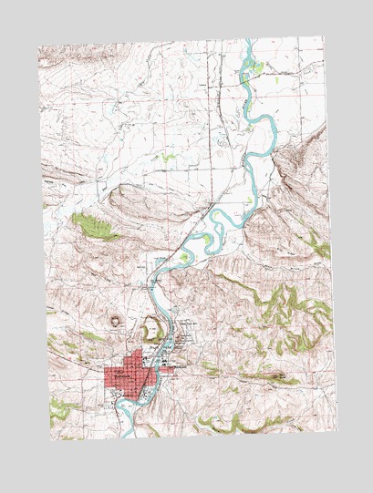
Thermopolis, WY USGS Topographic Map
Click on map above to begin viewing in our Map Viewer.

This topographic map contains these locations and features:
Feature Name Type Latitude Longitude GNIS ID View Map
Andreen PitMineN43.7086°W108.1684°1745987View Map
Big SpringSpringN43.6546°W108.1944°1597595View Map
Black ButteSummitN43.6433°W108.1504°1597597View Map
Black Sulphur SpringSpringN43.6553°W108.1947°1597598View Map
Black Willow DrawValleyN43.6888°W108.1707°1597599View Map
Blue RidgeRidgeN43.6822°W108.1454°1597600View Map
Canyon Hills Manor HospitalHospitalN43.6461°W108.2120°1794918View Map
Cover SloughLakeN43.6807°W108.1998°1597604View Map
Dempsey CanalCanalN43.7269°W108.2134°1597607View Map
Devils Punch BowlBasinN43.6616°W108.1915°1609082View Map
East ThermopolisPopulated PlaceN43.6463°W108.1982°1597608View Map
Harvey PitMineN43.7147°W108.1634°1745988View Map
Hill SchoolSchoolN43.6461°W108.2179°1597618View Map
Hot Springs County High SchoolSchoolN43.6499°W108.2060°1795527View Map
Hot Springs County Memorial HospitalHospitalN43.6480°W108.1993°1794895View Map
Hot Springs County-Thermopolis Municipal AirportAirportN43.6638°W108.2110°1605629View Map
Hot Springs State ParkParkN43.6552°W108.1993°1597620View Map
Kirby CreekStreamN43.7441°W108.1570°1597623View Map
Kirby DitchCanalN43.6825°W108.1751°1597624View Map
Kirby DitchCanalN43.7438°W108.1365°1597625View Map
KTHE-AM (Thermopolis)TowerN43.6450°W108.2048°1608817View Map
LucernePopulated PlaceN43.7350°W108.1765°1597627View Map
Lucerne Census Designated PlaceCensusN43.7136°W108.1872°2408151View Map
Lucerne MineMineN43.6519°W108.2095°1745991View Map
Lucerne SchoolSchoolN43.6461°W108.2120°1795529View Map
Meeteetse DrawValleyN43.6991°W108.2418°1597628View Map
Milek Family CemeteryCemeteryN43.6645°W108.1930°2774455View Map
Monument HillSummitN43.6566°W108.1923°1597630View Map
Monument Hill CemeteryCemeteryN43.6588°W108.2168°1597631View Map
Mortimore's Ambulance ServiceBuildingN43.6477°W108.2127°2673554View Map
N-vam MineMineN43.6358°W108.2051°1745986View Map
Owl CreekStreamN43.7233°W108.1587°1609136View Map
Park PitMineN43.6497°W108.1982°1745989View Map
Pioneer HomeLocaleN43.6491°W108.1993°1597635View Map
Rainbow TerracesLakeN43.6534°W108.1953°1597636View Map
Ralph Witters Elementary SchoolSchoolN43.6482°W108.2083°1795530View Map
Red LanePopulated PlaceN43.6786°W108.2059°1597638View Map
Red Lane GulchValleyN43.6744°W108.2045°1597639View Map
Riverside CemeteryCemeteryN43.6357°W108.2252°1597640View Map
Round TopSummitN43.6619°W108.2198°1597642View Map
Scotch PlungeLakeN43.6725°W108.2051°1597643View Map
Shafer PitMineN43.7075°W108.1834°1745990View Map
Smoky Row CemeteryCemeteryN43.6525°W108.1911°2774456View Map
South Fork Warm Springs CreekStreamN43.6277°W108.1476°1597657View Map
South Side DitchCanalN43.7041°W108.1995°1597646View Map
T HillSummitN43.6583°W108.2048°1597647View Map
Teepee FountainSpringN43.6522°W108.2001°1597648View Map
The Maytag SpringSpringN43.6744°W108.2044°1597650View Map
ThermopolisPopulated PlaceN43.6461°W108.2120°1597651View Map
Thermopolis Hot SpringsSpringN43.6538°W108.1945°1794810View Map
Thermopolis Middle SchoolSchoolN43.6413°W108.2282°1795528View Map
Thermopolis Police DepartmentBuildingN43.6470°W108.2094°2752640View Map
Thermopolis Post OfficePost OfficeN43.6475°W108.2097°2765617View Map
Thermopolis Volunteer Fire DepartmentBuildingN43.6427°W108.2263°2673452View Map
Town of East ThermopolisCivilN43.6441°W108.1979°2412461View Map
Town of ThermopolisCivilN43.6479°W108.2139°2413384View Map
Warm Springs CreekStreamN43.6455°W108.2026°1597652View Map

Note: Coordinates in the location and feature list above are referenced to NAD83 datum.


Copyright (C) 2008-2024 Ryan Niemi / Sunset Dynamics ... All Rights Reserved