TopoQuest Logo
Do you find TopoQuest useful?
Help keep TopoQuest running and adding new maps/features by donating!
Bitcoin:  19c7KJd3qBynnjoSw5npx9KScwjBe4ifkT
Litecoin:  LXs6TkuXGGXo1vDsWCkWVdjQX94eUKd6ui
Home View Maps Find Maps Find Places Resources & Links


Thompson Corner, Oklahoma Topographic Map

USGS Map Title: Thompson Corner, OK
USGS Map MRC: 35095H1
DRG (GeoTIFF) Download: o35095h1.tif


Neighboring USGS Topographic Map Quads:


  Cedar Crest, OK  
36095A2
 

  Peggs, OK  
36095A1
 

  Moodys, OK  
36094A8
 

  Hulbert, OK  
35095H2
 

  Thompson Corner, OK  
35095H1
 

  Tahlequah, OK  
35094H8
 

  Fort Gibson Dam, OK  
35095G2
 

  Zeb, OK  
35095G1
 

  Park Hill, OK  
35094G8


Map MRC Location:

N36°
W96°
N36°
W95°
H8 H7 H6 H5 H4 H3 H2 H1
G8 G7 G6 G5 G4 G3 G2 G1
F8 F7 F6 F5 F4 F3 F2 F1
E8 E7 E6 E5 E4 E3 E2 E1
D8 D7 D6 D5 D4 D3 D2 D1
C8 C7 C6 C5 C4 C3 C2 C1
B8 B7 B6 B5 B4 B3 B2 B1
A8 A7 A6 A5 A4 A3 A2 A1
N35°
W96°
N35°
W95°

Thompson Corner, OK USGS 1:24K Topographic Map Preview:
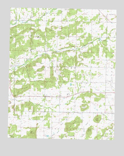
Thompson Corner, OK USGS Topographic Map
Click on map above to begin viewing in our Map Viewer.

This topographic map contains these locations and features:
Feature Name Type Latitude Longitude GNIS ID View Map
Brown MountainSummitN35.9226°W95.1061°1090536View Map
Bynum RidgeRidgeN35.9804°W95.0688°1090775View Map
Cactus HillSummitN35.9293°W95.1147°1090793View Map
Crittenden CemeteryCemeteryN35.9289°W95.0355°2711308View Map
Double Spring ChurchChurchN35.9640°W95.0472°1092153View Map
Double Springs CemeteryCemeteryN35.9629°W95.0487°2711309View Map
Eureka CemeteryCemeteryN35.8764°W95.0746°1092658View Map
GabrielPopulated PlaceN35.9284°W95.0650°1763566View Map
GrandviewCivilN35.9581°W95.0072°2631111View Map
Grandview Census Designated PlaceCensusN35.9556°W95.0047°2584381View Map
Hawkins MountainSummitN35.8943°W95.0213°1093604View Map
Houston CemeteryCemeteryN35.9573°W95.0766°1093975View Map
Houston CemeteryCemeteryN35.9606°W95.0811°1093976View Map
Johnson CemeteryCemeteryN35.9443°W95.1238°1094246View Map
Keener KnobSummitN35.9412°W95.0866°1094309View Map
Ketcher SpringSpringN35.9498°W95.0769°1094350View Map
Kolpin MountainSummitN35.8865°W95.0502°1094429View Map
Miller CemeteryCemeteryN35.8777°W95.0486°1095411View Map
Money Bean HollowValleyN35.9440°W95.1066°1095474View Map
Morrison MountainSummitN35.8829°W95.0297°1095530View Map
Mount Zion CemeteryCemeteryN35.9160°W95.0654°2711315View Map
Mount Zion ChurchChurchN35.9159°W95.0655°1095632View Map
New Hope CemeteryCemeteryN35.9465°W95.1161°1095809View Map
New Hope ChurchChurchN35.9387°W95.1191°1095821View Map
Ogles MountainSummitN35.9720°W95.0944°1096179View Map
Oknoname 021001 DamDamN35.9268°W95.0519°1755769View Map
Oknoname 021001 ReservoirReservoirN35.9276°W95.0523°1755770View Map
Parris CemeteryCemeteryN35.9990°W95.0608°1096452View Map
Seminary SpringSpringN35.9704°W95.0183°1097907View Map
Shady GrovePopulated PlaceN35.9443°W95.0950°1853481View Map
Shady GroveCivilN35.9485°W95.0952°2631171View Map
Shady Grove Census Designated PlaceCensusN35.9485°W95.0952°2408717View Map
Shady Grove Elementary SchoolSchoolN35.9594°W95.1002°1097945View Map
Stick Ross MountainSummitN35.8829°W95.0097°1098533View Map
Sugar MountainSummitN35.8809°W95.0966°1098605View Map
Swimmer Baptist CemeteryCemeteryN35.9905°W95.0986°2711321View Map
Swimmer ChurchChurchN35.9909°W95.0997°1098699View Map
Tahlequah DivisionCivilN35.9077°W95.0045°1937883View Map
Tahlequah Municipal AirportAirportN35.9261°W95.0028°1102685View Map
Thompson CornerPopulated PlaceN35.9154°W95.0827°1100883View Map
Thompson MountainSummitN35.9045°W95.0366°1098865View Map
Township of CrittendenCivilN35.9445°W95.0641°1824588View Map
Wagoner Community Hospital HeliportAirportN35.9501°W95.0502°1102723View Map

Note: Coordinates in the location and feature list above are referenced to NAD83 datum.


Copyright (C) 2008-2024 Ryan Niemi / Sunset Dynamics ... All Rights Reserved