TopoQuest Logo
Do you find TopoQuest useful?
Help keep TopoQuest running and adding new maps/features by donating!
Bitcoin:  19c7KJd3qBynnjoSw5npx9KScwjBe4ifkT
Litecoin:  LXs6TkuXGGXo1vDsWCkWVdjQX94eUKd6ui
Home View Maps Find Maps Find Places Resources & Links


Thornapple, Wisconsin Topographic Map

USGS Map Title: Thornapple, WI
USGS Map MRC: 45091D2
DRG (GeoTIFF) Download: o45091d2.tif


Neighboring USGS Topographic Map Quads:


  Becky Creek, WI  
45091E3
 

  Crane, WI  
45091E2
 

  Exeland SE, WI  
45091E1
 

  Bruce, WI  
45091D3
 

  Thornapple, WI  
45091D2
 

  Ladysmith, WI  
45091D1
 

  Fireside Lakes, WI  
45091C3
 

  Flambeau Ridge, WI  
45091C2
 

  Ladysmith SE, WI  
45091C1


Map MRC Location:

N46°
W92°
N46°
W91°
H8 H7 H6 H5 H4 H3 H2 H1
G8 G7 G6 G5 G4 G3 G2 G1
F8 F7 F6 F5 F4 F3 F2 F1
E8 E7 E6 E5 E4 E3 E2 E1
D8 D7 D6 D5 D4 D3 D2 D1
C8 C7 C6 C5 C4 C3 C2 C1
B8 B7 B6 B5 B4 B3 B2 B1
A8 A7 A6 A5 A4 A3 A2 A1
N45°
W92°
N45°
W91°

Thornapple, WI USGS 1:24K Topographic Map Preview:
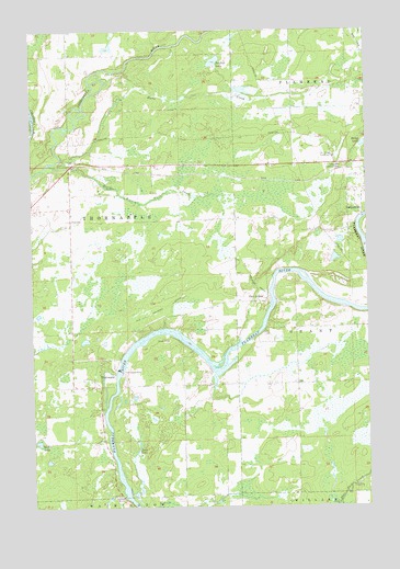
Thornapple, WI USGS Topographic Map
Click on map above to begin viewing in our Map Viewer.

This topographic map contains these locations and features:
Feature Name Type Latitude Longitude GNIS ID View Map
Bell School (historical)SchoolN45.4827°W91.1518°1867763View Map
Dump LakeLakeN45.4699°W91.1263°1564170View Map
Flambeau EstatesPopulated PlaceN45.3881°W91.2217°2611837View Map
Girard School (historical)SchoolN45.4069°W91.2302°1867786View Map
Ladysmith Lookout TowerTowerN45.4650°W91.1340°1581252View Map
Lone Birch School (historical)SchoolN45.4016°W91.1946°1867809View Map
Long LakeLakeN45.3897°W91.2116°1568554View Map
Northland Estates Air Village Airport (historical)AirportN45.4686°W91.1457°1582042View Map
Pleasant View School (historical)SchoolN45.4502°W91.2349°1867830View Map
Port ArthurPopulated PlaceN45.4291°W91.1621°1571795View Map
Port Arthur Dam (historical)DamN45.4291°W91.1604°1867832View Map
River Heights School (historical)SchoolN45.4477°W91.1321°1867834View Map
Riverside MissionChurchN45.3777°W91.2168°1572371View Map
Rusk CountyCivilN45.4751°W91.1331°1581114View Map
Saxton LakeLakeN45.3921°W91.2483°1573761View Map
South Branch Twin CreekStreamN45.4655°W91.2374°1574418View Map
Sunfish LakeLakeN45.4918°W91.1815°1575075View Map
ThornapplePopulated PlaceN45.4097°W91.2196°1575398View Map
Thornapple Church (historical)ChurchN45.4064°W91.2296°1867860View Map
Thornapple DamDamN45.4108°W91.2171°1575400View Map
Thornapple Flowage 1965ReservoirN45.4116°W91.2168°1793059View Map
Thornapple Hydro Generating StationLocaleN45.4111°W91.2183°2742371View Map
Thornapple School (historical)SchoolN45.4864°W91.2360°1867861View Map
Thornapple TownhallBuildingN45.4502°W91.2349°1867862View Map
Thornapple WP148 DamDamN45.4116°W91.2168°1793058View Map
Town of ThornappleCivilN45.4518°W91.2225°1584274View Map
Twin CreekStreamN45.4652°W91.2432°1575775View Map
West Grant School (historical)SchoolN45.4069°W91.1529°1867866View Map

Note: Coordinates in the location and feature list above are referenced to NAD83 datum.


Copyright (C) 2008-2025 Ryan Niemi / Sunset Dynamics ... All Rights Reserved