TopoQuest Logo
Do you find TopoQuest useful?
Help keep TopoQuest running and adding new maps/features by donating!
Bitcoin:  19c7KJd3qBynnjoSw5npx9KScwjBe4ifkT
Litecoin:  LXs6TkuXGGXo1vDsWCkWVdjQX94eUKd6ui
Home View Maps Find Maps Find Places Resources & Links


Three Rivers, Texas Topographic Map

USGS Map Title: Three Rivers, TX
USGS Map MRC: 28098D2
DRG (GeoTIFF) Download: o28098d2.tif


Neighboring USGS Topographic Map Quads:


  Willow Hollow Tank, TX  
28098E3
 

  Comanche Hills, TX  
28098E2
 

  Ray Point, TX  
28098E1
 

  Calliham, TX  
28098D3
 

  Three Rivers, TX  
28098D2
 

  Oakville, TX  
28098D1
 

  Live Oak Hollow, TX  
28098C3
 

  Oakville SW, TX  
28098C2
 

  George West, TX  
28098C1


Map MRC Location:

N29°
W99°
N29°
W98°
H8 H7 H6 H5 H4 H3 H2 H1
G8 G7 G6 G5 G4 G3 G2 G1
F8 F7 F6 F5 F4 F3 F2 F1
E8 E7 E6 E5 E4 E3 E2 E1
D8 D7 D6 D5 D4 D3 D2 D1
C8 C7 C6 C5 C4 C3 C2 C1
B8 B7 B6 B5 B4 B3 B2 B1
A8 A7 A6 A5 A4 A3 A2 A1
N28°
W99°
N28°
W98°

Three Rivers, TX USGS 1:24K Topographic Map Preview:
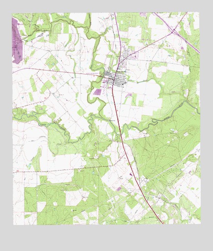
Three Rivers, TX USGS Topographic Map
Click on map above to begin viewing in our Map Viewer.

This topographic map contains these locations and features:
Feature Name Type Latitude Longitude GNIS ID View Map
Atascosa RiverStreamN28.4905°W98.1992°1372352View Map
Beefmasters Best Airport (historical)AirportN28.3956°W98.2211°1387641View Map
Charley York HollowValleyN28.4844°W98.2442°1332690View Map
Choke Canyon State Park - South Shore UnitParkN28.4739°W98.2433°2028595View Map
City of Three RiversCivilN28.4669°W98.1784°2412068View Map
Frio RiverStreamN28.4375°W98.1886°1373780View Map
Hackberry CreekStreamN28.4861°W98.1925°1373959View Map
IkePopulated PlaceN28.3914°W98.1545°1378478View Map
Live Oak HollowValleyN28.4902°W98.2318°1340255View Map
Oakville-Wilcox Gas FieldOilfieldN28.4072°W98.1339°1375252View Map
Olds SloughStreamN28.4511°W98.1364°1343249View Map
Rex Cabaniss CreekStreamN28.4239°W98.2128°1345127View Map
Rock Quarry BranchStreamN28.4481°W98.1342°1375788View Map
Salt BranchStreamN28.4225°W98.2256°1346204View Map
Sinclair HollowValleyN28.4894°W98.2283°1347167View Map
Sinclair LakeLakeN28.4841°W98.2385°1347168View Map
Three RiversPopulated PlaceN28.4603°W98.1825°1348525View Map
Three Rivers DamDamN28.4619°W98.1903°1859139View Map
Three Rivers LakeReservoirN28.4670°W98.1925°1859140View Map
Three Rivers Police DepartmentBuildingN28.4713°W98.1778°2750514View Map
Three Rivers Post OfficePost OfficeN28.4613°W98.1813°2731753View Map
Three Rivers Volunteer Fire DepartmentBuildingN28.4729°W98.1785°2551388View Map
Tips ParkParkN28.4630°W98.1903°1348596View Map

Note: Coordinates in the location and feature list above are referenced to NAD83 datum.


Copyright (C) 2008-2025 Ryan Niemi / Sunset Dynamics ... All Rights Reserved