TopoQuest Logo
Do you find TopoQuest useful?
Help keep TopoQuest running and adding new maps/features by donating!
Bitcoin:  19c7KJd3qBynnjoSw5npx9KScwjBe4ifkT
Litecoin:  LXs6TkuXGGXo1vDsWCkWVdjQX94eUKd6ui
Home View Maps Find Maps Find Places Resources & Links


Tiffany, Colorado Topographic Map

USGS Map Title: Tiffany, CO
USGS Map MRC: 37107A5
DRG (GeoTIFF) Download: o37107a5.tif


Neighboring USGS Topographic Map Quads:


  Gem Village, CO  
37107B6
 

  Bayfield, CO  
37107B5
 

  Pargin Mountain, CO  
37107B4
 

  Ignacio, CO  
37107A6
 

  Tiffany, CO  
37107A5
 

  Allison, CO  
37107A4
 

  Anastacio Spring, NM  
36107H6
 

  Burnt Mesa, NM  
36107H5
 

  Bancos Mesa NW, NM  
36107H4


Map MRC Location:

N38°
W108°
N38°
W107°
H8 H7 H6 H5 H4 H3 H2 H1
G8 G7 G6 G5 G4 G3 G2 G1
F8 F7 F6 F5 F4 F3 F2 F1
E8 E7 E6 E5 E4 E3 E2 E1
D8 D7 D6 D5 D4 D3 D2 D1
C8 C7 C6 C5 C4 C3 C2 C1
B8 B7 B6 B5 B4 B3 B2 B1
A8 A7 A6 A5 A4 A3 A2 A1
N37°
W108°
N37°
W107°

Tiffany, CO USGS 1:24K Topographic Map Preview:
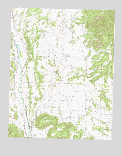
Tiffany, CO USGS Topographic Map
Click on map above to begin viewing in our Map Viewer.

This topographic map contains these locations and features:
Feature Name Type Latitude Longitude GNIS ID View Map
Allison Tiffany CemeteryCemeteryN37.0275°W107.5196°184492View Map
Devil CreekStreamN37.0772°W107.5612°184488View Map
Ignacio DivisionCivilN37.1080°W107.6069°1935491View Map
Indian MesaSummitN37.0167°W107.5828°184489View Map
Indian Spring Creek LateralCanalN37.0556°W107.5951°184495View Map
Jones ArroyoValleyN37.0543°W107.5755°184497View Map
La BocaPopulated PlaceN37.0111°W107.6020°184499View Map
La Boca CanyonValleyN37.0114°W107.6055°184477View Map
La Boca CemeteryCemeteryN37.0005°W107.5962°184502View Map
La Boca DitchCanalN37.0417°W107.6173°184500View Map
Los Pinos Fire Protection District Station 4 Allison AreaBuildingN37.0494°W107.5278°2667034View Map
Middle MesaSummitN37.0064°W107.5562°203017View Map
Pine River CanalCanalN37.0833°W107.5217°203006View Map
Pine River Watershed PR-1 DamDamN37.0667°W107.5256°200098View Map
Pine River Watershed PR-1 ReservoirReservoirN37.0674°W107.5230°200099View Map
Pine River Watershed PR-2 DamDamN37.1017°W107.5356°200100View Map
Pine River Watershed PR-2 ReservoirReservoirN37.1017°W107.5356°200101View Map
Salabar DrawValleyN37.0679°W107.5702°184498View Map
Servero DitchCanalN37.0917°W107.6109°184501View Map
Shellhammer RidgeRidgeN37.0847°W107.5964°203008View Map
South Pine River LateralCanalN37.0222°W107.5334°203018View Map
Southern Ute Census Designated PlaceCensusN37.0749°W107.5933°2583299View Map
Spring CreekStreamN37.0044°W107.5989°184398View Map
TiffanyPopulated PlaceN37.0328°W107.5381°184493View Map
Tiffany CemeteryCemeteryN37.0089°W107.5414°184490View Map
Tiffany DrawValleyN37.0330°W107.5753°184494View Map
Tiffany PeakSummitN37.0117°W107.5526°184491View Map
Tunnel HillSummitN37.0622°W107.5370°184496View Map
Ute CreekStreamN37.0869°W107.6148°184401View Map
West Lateral Spring Creek Extension DitchCanalN37.1083°W107.5937°203005View Map

Note: Coordinates in the location and feature list above are referenced to NAD83 datum.


Copyright (C) 2008-2025 Ryan Niemi / Sunset Dynamics ... All Rights Reserved