TopoQuest Logo
Do you find TopoQuest useful?
Help keep TopoQuest running and adding new maps/features by donating!
Bitcoin:  19c7KJd3qBynnjoSw5npx9KScwjBe4ifkT
Litecoin:  LXs6TkuXGGXo1vDsWCkWVdjQX94eUKd6ui
Home View Maps Find Maps Find Places Resources & Links


Tinian, New Mexico Topographic Map

USGS Map Title: Tinian, NM
USGS Map MRC: 35107G3
DRG (GeoTIFF) Download: o35107g3.tif


Neighboring USGS Topographic Map Quads:


  Star Lake, NM  
35107H4
 

  Ojo Encino Mesa, NM  
35107H3
 

  Johnson Trading Post, NM  
35107H2
 

  Rincon Marquez, NM  
35107G4
 

  Tinian, NM  
35107G3
 

  Wolf Stand, NM  
35107G2
 

  Mesita Del Gavilan, NM  
35107F4
 

  Canada Calladita, NM  
35107F3
 

  Arroyo Empedrado, NM  
35107F2


Map MRC Location:

N36°
W108°
N36°
W107°
H8 H7 H6 H5 H4 H3 H2 H1
G8 G7 G6 G5 G4 G3 G2 G1
F8 F7 F6 F5 F4 F3 F2 F1
E8 E7 E6 E5 E4 E3 E2 E1
D8 D7 D6 D5 D4 D3 D2 D1
C8 C7 C6 C5 C4 C3 C2 C1
B8 B7 B6 B5 B4 B3 B2 B1
A8 A7 A6 A5 A4 A3 A2 A1
N35°
W108°
N35°
W107°

Tinian, NM USGS 1:24K Topographic Map Preview:
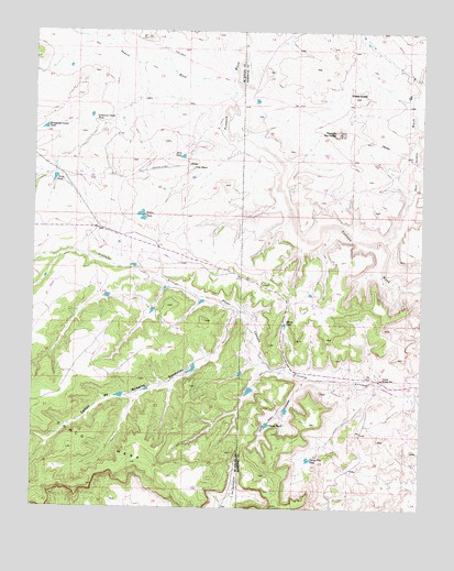
Tinian, NM USGS Topographic Map
Click on map above to begin viewing in our Map Viewer.

This topographic map contains these locations and features:
Feature Name Type Latitude Longitude GNIS ID View Map
15R-312 Water WellWellN35.8209°W107.3225°921956View Map
15R-315 Water WellWellN35.7889°W107.3289°921833View Map
19K-333 Water WellWellN35.8572°W107.3387°921286View Map
Cactus Flat TankReservoirN35.7629°W107.2865°887060View Map
Chasm DamDamN35.7717°W107.2989°923830View Map
Chasm TankReservoirN35.7718°W107.2999°887457View Map
Homestead Corner TankReservoirN35.8495°W107.3721°890096View Map
Julio Juan CanyonValleyN35.7839°W107.2859°890603View Map
Marys TankReservoirN35.7982°W107.2944°891666View Map
Mesa de San FelipeSummitN35.8484°W107.2775°898009View Map
Noberto Sandoval CaņonValleyN35.8017°W107.3092°892548View Map
Papers WashStreamN35.8581°W107.3098°897433View Map
Piņon CanyonValleyN35.7811°W107.2625°893307View Map
Pinon Canyon Dam Number FourDamN35.7817°W107.3056°923826View Map
Pinon Canyon Dam Number OneDamN35.8134°W107.3506°923825View Map
Pinto TankReservoirN35.8362°W107.3689°893323View Map
R-51 Water WellWellN35.7534°W107.2795°922727View Map
San Isidro WashStreamN35.8195°W107.2623°897469View Map
Sheep Queen HillSummitN35.8584°W107.2720°899911View Map
Store TankReservoirN35.8420°W107.3279°895373View Map
TinianPopulated PlaceN35.8400°W107.3262°899956View Map
Tinian MissionChurchN35.8392°W107.3242°895691View Map
Tinian TankReservoirN35.8266°W107.3408°895692View Map
Tinian Trading PostLocaleN35.8339°W107.3175°928372View Map
Torreon ChapterCivilN35.7834°W107.2822°2419497View Map
Torreon Trading PostLocaleN35.7839°W107.2628°915907View Map
Uranium Claim TankReservoirN35.8511°W107.3564°896051View Map

Note: Coordinates in the location and feature list above are referenced to NAD83 datum.


Copyright (C) 2008-2025 Ryan Niemi / Sunset Dynamics ... All Rights Reserved