TopoQuest Logo
Do you find TopoQuest useful?
Help keep TopoQuest running and adding new maps/features by donating!
Bitcoin:  19c7KJd3qBynnjoSw5npx9KScwjBe4ifkT
Litecoin:  LXs6TkuXGGXo1vDsWCkWVdjQX94eUKd6ui
Home View Maps Find Maps Find Places Resources & Links


Tippipah Spring, Nevada Topographic Map

USGS Map Title: Tippipah Spring, NV
USGS Map MRC: 37116A2
DRG (GeoTIFF) Download: o37116a2.tif


Neighboring USGS Topographic Map Quads:


  Ammonia Tanks, NV  
37116B3
 

  Rainier Mesa, NV  
37116B2
 

  Oak Spring, NV  
37116B1
 

  Buckboard Mesa, NV  
37116A3
 

  Tippipah Spring, NV  
37116A2
 

  Yucca Flat, NV  
37116A1
 

  Topopah Spring, NV  
36116H3
 

  Mine Mountain, NV  
36116H2
 

  Yucca Lake, NV  
36116H1


Map MRC Location:

N38°
W117°
N38°
W116°
H8 H7 H6 H5 H4 H3 H2 H1
G8 G7 G6 G5 G4 G3 G2 G1
F8 F7 F6 F5 F4 F3 F2 F1
E8 E7 E6 E5 E4 E3 E2 E1
D8 D7 D6 D5 D4 D3 D2 D1
C8 C7 C6 C5 C4 C3 C2 C1
B8 B7 B6 B5 B4 B3 B2 B1
A8 A7 A6 A5 A4 A3 A2 A1
N37°
W117°
N37°
W116°

Tippipah Spring, NV USGS 1:24K Topographic Map Preview:
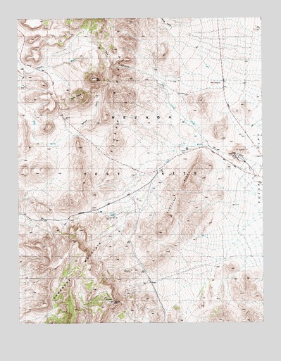
Tippipah Spring, NV USGS Topographic Map
Click on map above to begin viewing in our Map Viewer.

This topographic map contains these locations and features:
Feature Name Type Latitude Longitude GNIS ID View Map
Area 1 Shaker PlantLocaleN37.0683°W116.1389°849784View Map
Belted Mount SpringSpringN37.1047°W116.2406°851800View Map
Big ButteSummitN37.1005°W116.2109°838718View Map
Eleana RangeRangeN37.1116°W116.1959°840324View Map
Gap WashArroyoN37.0597°W116.1300°849594View Map
Grouse CanyonValleyN37.1222°W116.1650°840829View Map
Horse WashStreamN37.1030°W116.2473°841116View Map
Nevada Test Site Area 16LocaleN37.0452°W116.1942°848253View Map
Nevada Test Site Area 17LocaleN37.1244°W116.1937°848319View Map
Pediment WashArroyoN37.0727°W116.1600°849529View Map
Red CanyonValleyN37.0930°W116.1728°843134View Map
Red Canyon WashArroyoN37.0725°W116.1534°849530View Map
Redrock ValleyValleyN37.0788°W116.2200°843181View Map
Sugar LoavesSummitN37.0927°W116.2209°845686View Map
Syncline RidgeRidgeN37.0522°W116.1678°844148View Map
The GapGapN37.0963°W116.2462°844255View Map
Tippipah PointSummitN37.0083°W116.2023°844329View Map
Tippipah SpringSpringN37.0435°W116.2042°858214View Map
Water TunnelTunnelN37.0436°W116.2039°844677View Map

Note: Coordinates in the location and feature list above are referenced to NAD83 datum.


Copyright (C) 2008-2024 Ryan Niemi / Sunset Dynamics ... All Rights Reserved