TopoQuest Logo
Do you find TopoQuest useful?
Help keep TopoQuest running and adding new maps/features by donating!
Bitcoin:  19c7KJd3qBynnjoSw5npx9KScwjBe4ifkT
Litecoin:  LXs6TkuXGGXo1vDsWCkWVdjQX94eUKd6ui
Home View Maps Find Maps Find Places Resources & Links


Tofte, Minnesota Topographic Map

USGS Map Title: Tofte, MN
USGS Map MRC: 47090E7
DRG (GeoTIFF) Download: o47090e7.tif


Neighboring USGS Topographic Map Quads:


  Toohey Lake, MN  
47090F8
 

  Honeymoon Mountain, MN  
47090F7
 

  Lutsen, MN  
47090F6
 

  Schroeder, MN  
47090E8
 

  Tofte, MN  
47090E7


Map MRC Location:

N48°
W91°
N48°
W90°
H8 H7 H6 H5 H4 H3 H2 H1
G8 G7 G6 G5 G4 G3 G2 G1
F8 F7 F6 F5 F4 F3 F2 F1
E8 E7 E6 E5 E4 E3 E2 E1
D8 D7 D6 D5 D4 D3 D2 D1
C8 C7 C6 C5 C4 C3 C2 C1
B8 B7 B6 B5 B4 B3 B2 B1
A8 A7 A6 A5 A4 A3 A2 A1
N47°
W91°
N47°
W90°

Tofte, MN USGS 1:24K Topographic Map Preview:
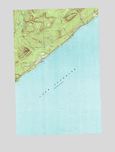
Tofte, MN USGS Topographic Map
Click on map above to begin viewing in our Map Viewer.

This topographic map contains these locations and features:
Feature Name Type Latitude Longitude GNIS ID View Map
Birch Grove Elementary SchoolSchoolN47.5667°W90.8611°2072917View Map
Carlton CreekStreamN47.5796°W90.8235°655648View Map
Carlton PeakSummitN47.5832°W90.8601°655649View Map
Grevais Landing Field (historical)AirportN47.5877°W90.8238°659108View Map
Hidden FallsFallsN47.5566°W90.8743°656579View Map
Leveaux CreekStreamN47.5960°W90.7907°656996View Map
Leveaux MountainSummitN47.6155°W90.7976°656997View Map
Onion RiverStreamN47.6080°W90.7710°657680View Map
Ray Berglund Wayside and Recreation SiteParkN47.6085°W90.7707°659109View Map
Rollins CreekStreamN47.6168°W90.7518°658082View Map
Sawtooth Mountain ClinicHospitalN47.5739°W90.8361°2072915View Map
Superior Hiking TrailTrailN47.5736°W90.8361°2094028View Map
Temperance RiverStreamN47.5532°W90.8735°658627View Map
Temperance River Roadside Parking AreaParkN47.5547°W90.8744°2073044View Map
Temperance River State ParkParkN47.5543°W90.8724°659111View Map
ToftePopulated PlaceN47.5738°W90.8363°658702View Map
Tofte Airport (historical)AirportN47.5877°W90.8235°660442View Map
Tofte CemeteryCemeteryN47.5746°W90.8416°2072912View Map
Tofte Post OfficePost OfficeN47.5739°W90.8361°2072916View Map
Tofte Volunteer Fire and Rescue DepartmentBuildingN47.5724°W90.8375°2072914View Map
Zoar Lutheran ChurchChurchN47.5739°W90.8361°2072913View Map

Note: Coordinates in the location and feature list above are referenced to NAD83 datum.


Copyright (C) 2008-2024 Ryan Niemi / Sunset Dynamics ... All Rights Reserved