TopoQuest Logo
Do you find TopoQuest useful?
Help keep TopoQuest running and adding new maps/features by donating!
Bitcoin:  19c7KJd3qBynnjoSw5npx9KScwjBe4ifkT
Litecoin:  LXs6TkuXGGXo1vDsWCkWVdjQX94eUKd6ui
Home View Maps Find Maps Find Places Resources & Links


Tolono, Illinois Topographic Map

USGS Map Title: Tolono, IL
USGS Map MRC: 39088H3
DRG (GeoTIFF) Download: o39088h3.tif


Neighboring USGS Topographic Map Quads:


  Seymour, IL  
40088A4
 

  Bondville, IL  
40088A3
 

  Urbana, IL  
40088A2
 

  Ivesdale, IL  
39088H4
 

  Tolono, IL  
39088H3
 

  Villa Grove NW, IL  
39088H2
 

  Atwood, IL  
39088G4
 

  Tuscola, IL  
39088G3
 

  Villa Grove, IL  
39088G2


Map MRC Location:

N40°
W89°
N40°
W88°
H8 H7 H6 H5 H4 H3 H2 H1
G8 G7 G6 G5 G4 G3 G2 G1
F8 F7 F6 F5 F4 F3 F2 F1
E8 E7 E6 E5 E4 E3 E2 E1
D8 D7 D6 D5 D4 D3 D2 D1
C8 C7 C6 C5 C4 C3 C2 C1
B8 B7 B6 B5 B4 B3 B2 B1
A8 A7 A6 A5 A4 A3 A2 A1
N39°
W89°
N39°
W88°

Tolono, IL USGS 1:24K Topographic Map Preview:
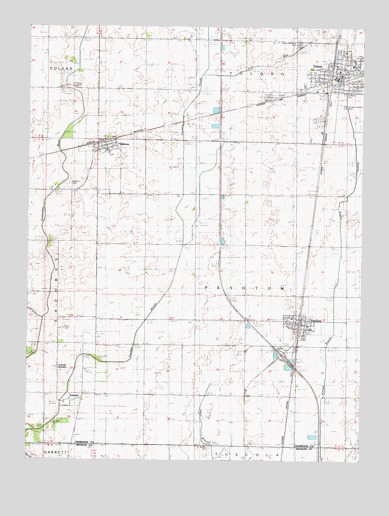
Tolono, IL USGS Topographic Map
Click on map above to begin viewing in our Map Viewer.

This topographic map contains these locations and features:
Feature Name Type Latitude Longitude GNIS ID View Map
Bailey Memorial CemeteryCemeteryN39.9956°W88.2742°403808View Map
Baldwin School (historical)SchoolN39.9375°W88.3498°403858View Map
Craw CemeteryCemeteryN39.9836°W88.3578°406751View Map
Dean Schwenk RLA AirportAirportN39.9161°W88.3055°2770522View Map
First Baptist ChurchChurchN39.9867°W88.2637°1955826View Map
Illinois State Police District 10 Police DepartmentBuildingN39.9074°W88.2781°2759123View Map
Interchange 220CrossingN39.9056°W88.2798°1810775View Map
JimtownPopulated PlaceN39.9017°W88.3637°426974View Map
Kaskaskia DitchCanalN39.9917°W88.3562°411324View Map
Maley School (historical)SchoolN39.9528°W88.2931°412871View Map
Merry School (historical)SchoolN39.9517°W88.2548°413447View Map
Nelson CemeteryCemeteryN39.8786°W88.3067°414349View Map
O'Bryan CemeteryCemeteryN39.8853°W88.3648°414746View Map
Page RunStreamN39.9859°W88.3095°1984360View Map
ParkvillePopulated PlaceN39.8917°W88.3612°424530View Map
PesotumPopulated PlaceN39.9148°W88.2734°415575View Map
Pesotum CemeteryCemeteryN39.9125°W88.2695°1810809View Map
Pesotum Fire Protection District 1BuildingN39.9143°W88.2740°2681831View Map
Pesotum Grade SchoolSchoolN39.9161°W88.2762°1810810View Map
Pesotum Post OfficePost OfficeN39.9142°W88.2720°2788580View Map
Rock CemeteryCemeteryN39.9134°W88.3612°416793View Map
SadorusPopulated PlaceN39.9670°W88.3464°417110View Map
Sadorus CemeteryCemeteryN39.9548°W88.3595°417111View Map
Sadorus Fire DepartmentBuildingN39.9705°W88.3489°2682602View Map
Sadorus Grade SchoolSchoolN39.9636°W88.3451°1810816View Map
Sadorus Post OfficePost OfficeN39.9667°W88.3447°2788795View Map
Saint Marys CemeteryCemeteryN39.9806°W88.2570°1984363View Map
Saint Patrick CemeteryCemeteryN39.9809°W88.2570°1748048View Map
Saint Pauls Lutheran ChurchChurchN39.9645°W88.3453°1955828View Map
Stewart School (historical)SchoolN39.9823°W88.2937°419129View Map
TolonoPopulated PlaceN39.9861°W88.2589°425697View Map
Tolono Fire Department Station 1BuildingN39.9866°W88.2584°2682597View Map
Tolono Fire Department West StationBuildingN39.9857°W88.2637°2682281View Map
Tolono Post OfficePost OfficeN39.9861°W88.2610°2788911View Map
Tolono Primary SchoolSchoolN39.9867°W88.2581°1810841View Map
Tolono Village Police DepartmentBuildingN39.9840°W88.2695°2758947View Map
Township of PesotumCivilN39.9220°W88.2917°429554View Map
Unity Junior High SchoolSchoolN39.9889°W88.2539°1810848View Map
Village of PesotumCivilN39.9128°W88.2745°2399658View Map
Village of SadorusCivilN39.9669°W88.3452°2399154View Map
Village of TolonoCivilN39.9912°W88.2625°2399992View Map
West Side ParkParkN39.9875°W88.2684°1748053View Map

Note: Coordinates in the location and feature list above are referenced to NAD83 datum.


Copyright (C) 2008-2024 Ryan Niemi / Sunset Dynamics ... All Rights Reserved