TopoQuest Logo
Do you find TopoQuest useful?
Help keep TopoQuest running and adding new maps/features by donating!
Bitcoin:  19c7KJd3qBynnjoSw5npx9KScwjBe4ifkT
Litecoin:  LXs6TkuXGGXo1vDsWCkWVdjQX94eUKd6ui
Home View Maps Find Maps Find Places Resources & Links


Tony Grove Creek, Utah Topographic Map

USGS Map Title: Tony Grove Creek, UT
USGS Map MRC: 41111H5
DRG (GeoTIFF) Download: o41111h5.tif


Neighboring USGS Topographic Map Quads:


  Mapleton, ID  
42111A6
 

  Egan Basin, ID  
42111A5
 

  Saint Charles, ID  
42111A4
 

  Naomi Peak, UT  
41111H6
 

  Tony Grove Creek, UT  
41111H5
 

  Garden City, UT  
41111H4
 

  Mount Elmer, UT  
41111G6
 

  Temple Peak, UT  
41111G5
 

  Meadowville, UT  
41111G4


Map MRC Location:

N42°
W112°
N42°
W111°
H8 H7 H6 H5 H4 H3 H2 H1
G8 G7 G6 G5 G4 G3 G2 G1
F8 F7 F6 F5 F4 F3 F2 F1
E8 E7 E6 E5 E4 E3 E2 E1
D8 D7 D6 D5 D4 D3 D2 D1
C8 C7 C6 C5 C4 C3 C2 C1
B8 B7 B6 B5 B4 B3 B2 B1
A8 A7 A6 A5 A4 A3 A2 A1
N41°
W112°
N41°
W111°

Tony Grove Creek, UT USGS 1:24K Topographic Map Preview:
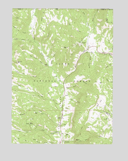
Tony Grove Creek, UT USGS Topographic Map
Click on map above to begin viewing in our Map Viewer.

This topographic map contains these locations and features:
Feature Name Type Latitude Longitude GNIS ID View Map
Amazon HollowValleyN41.9605°W111.5227°1438192View Map
Amazon MineMineN41.9630°W111.5066°1438193View Map
Beaver CreekStreamN41.9233°W111.5622°1438517View Map
Beaver CreekStreamN41.9230°W111.5619°377249View Map
Beaver MountainSummitN41.9641°W111.5580°1438536View Map
Beaver Mountain Ski AreaParkN41.9683°W111.5416°1438537View Map
Beaver SpringSpringN41.9480°W111.5818°1438546View Map
Brush CanyonValleyN41.9247°W111.5597°1439187View Map
Bunchgrass CreekStreamN41.8910°W111.5655°1439324View Map
Crab RidgeRidgeN41.9844°W111.5891°1440126View Map
Crescent Lake CanyonValleyN41.9777°W111.6024°1440151View Map
Goring PondLakeN41.9039°W111.5940°1441385View Map
Hansen HollowValleyN41.9477°W111.5780°1441581View Map
Hells Kitchen CanyonValleyN41.9469°W111.5813°1441694View Map
Horse LakeLakeN41.9317°W111.5179°1441886View Map
Lewis M Turner CampgroundLocaleN41.8849°W111.5727°1455885View Map
Little Bear CreekStreamN41.8785°W111.5630°1442661View Map
Little Bear SpringSpringN41.8781°W111.5458°1442667View Map
Long HollowValleyN41.9766°W111.5341°1442917View Map
North Fork Amazon HollowValleyN41.9597°W111.5072°1443884View Map
Peter SinksBasinN41.9127°W111.5188°1444297View Map
Peterson HollowValleyN41.9610°W111.5888°388375View Map
Peterson HollowValleyN41.9613°W111.5888°1444310View Map
Red BanksCliffN41.9008°W111.5627°1444758View Map
Red Banks CampgroundLocaleN41.8988°W111.5649°1444759View Map
Rex ReservoirReservoirN41.8984°W111.5065°1444875View Map
Rigby HollowValleyN41.9135°W111.5616°1444902View Map
Right ForkStreamN41.8880°W111.5844°1444980View Map
Sedge SpringSpringN41.8841°W111.5556°1445417View Map
Selman ReservoirReservoirN41.8937°W111.6032°1445429View Map
Sink HollowValleyN41.9772°W111.5310°390479View Map
Sink HollowValleyN41.9763°W111.5313°1445616View Map
Steam Mill CanyonValleyN41.9447°W111.5799°1446108View Map
Steam Mill PeakSummitN41.9502°W111.6194°1446110View Map
Steep HollowValleyN41.9702°W111.5991°1446123View Map
Stump HollowValleyN41.9594°W111.5297°1446205View Map
Tony GroveWoodsN41.8960°W111.5535°1454925View Map
Tony Grove CreekStreamN41.8866°W111.5641°1446648View Map
Tony Grove Memorial Guard StationLocaleN41.8858°W111.5666°1446650View Map
Utah State University Forestry Field StationSchoolN41.8769°W111.5619°1446897View Map
White Pine CreekStreamN41.9049°W111.5652°1447270View Map

Note: Coordinates in the location and feature list above are referenced to NAD83 datum.


Copyright (C) 2008-2025 Ryan Niemi / Sunset Dynamics ... All Rights Reserved