TopoQuest Logo
Do you find TopoQuest useful?
Help keep TopoQuest running and adding new maps/features by donating!
Bitcoin:  19c7KJd3qBynnjoSw5npx9KScwjBe4ifkT
Litecoin:  LXs6TkuXGGXo1vDsWCkWVdjQX94eUKd6ui
Home View Maps Find Maps Find Places Resources & Links


Torrey House, Texas Topographic Map

USGS Map Title: Torrey House, TX
USGS Map MRC: 35102E4
DRG (GeoTIFF) Download: o35102e4.tif


Neighboring USGS Topographic Map Quads:


  Proctor Ranch, TX  
35102F5
 

  Channing NW, TX  
35102F4
 

  Channing, TX  
35102F3
 

  Many Post Camp, TX  
35102E5
 

  Torrey House, TX  
35102E4
 

  Boys Ranch West, TX  
35102E3
 

  Alamocitos Camp, TX  
35102D5
 

  Torrey Peak, TX  
35102D4
 

  Halfway Creek, TX  
35102D3


Map MRC Location:

N36°
W103°
N36°
W102°
H8 H7 H6 H5 H4 H3 H2 H1
G8 G7 G6 G5 G4 G3 G2 G1
F8 F7 F6 F5 F4 F3 F2 F1
E8 E7 E6 E5 E4 E3 E2 E1
D8 D7 D6 D5 D4 D3 D2 D1
C8 C7 C6 C5 C4 C3 C2 C1
B8 B7 B6 B5 B4 B3 B2 B1
A8 A7 A6 A5 A4 A3 A2 A1
N35°
W103°
N35°
W102°

Torrey House, TX USGS 1:24K Topographic Map Preview:
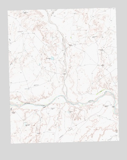
Torrey House, TX USGS Topographic Map
Click on map above to begin viewing in our Map Viewer.

This topographic map contains these locations and features:
Feature Name Type Latitude Longitude GNIS ID View Map
Bird Farm CampLocaleN35.5509°W102.4771°1352219View Map
Blue Dam TankReservoirN35.5281°W102.4333°1352454View Map
Coyote WindmillLocaleN35.5639°W102.4377°1355289View Map
Dry Pasture WindmillLocaleN35.5712°W102.3935°1356371View Map
East Cow Pasture WindmillLocaleN35.5850°W102.3910°1356600View Map
Elephant Head WindmillLocaleN35.6231°W102.4819°1356899View Map
Goodnight CanyonValleyN35.5335°W102.4986°1358162View Map
Goodnight WindmillLocaleN35.5292°W102.4980°1358168View Map
Halfway WindmillLocaleN35.5539°W102.4721°1358659View Map
Hollicott CrossingPopulated PlaceN35.5328°W102.3796°1379946View Map
Isabelle CampLocaleN35.5084°W102.3771°1360040View Map
Little Torrey CanyonValleyN35.5372°W102.4367°1361489View Map
Little Torrey WindmillLocaleN35.5325°W102.4524°1361490View Map
Los Redos CreekStreamN35.6109°W102.4480°1967739View Map
Los Redos CreekStreamN35.6106°W102.4458°1374732View Map
New Pasture WindmillLocaleN35.5328°W102.3910°1363757View Map
Old Goodnight TankReservoirN35.5187°W102.4835°1364426View Map
Punta de Agua CreekStreamN35.5420°W102.4366°1375583View Map
Ranch CreekStreamN35.5050°W102.3760°1375623View Map
Red Pen WindmillLocaleN35.6050°W102.4838°1366204View Map
Rita Blanca TankReservoirN35.5789°W102.4495°1366507View Map
Rita Blanca WindmillLocaleN35.5903°W102.4266°1366508View Map
Torrey CanyonValleyN35.5314°W102.4665°1370036View Map
Torrey Canyon WindmillLocaleN35.5089°W102.4699°1370037View Map
Torrey FlatsAreaN35.5195°W102.4116°1350832View Map
Torrey HouseLocaleN35.5334°W102.4591°1370038View Map
West Cow Pasture WindmillLocaleN35.5973°W102.4027°1371099View Map

Note: Coordinates in the location and feature list above are referenced to NAD83 datum.


Copyright (C) 2008-2025 Ryan Niemi / Sunset Dynamics ... All Rights Reserved