TopoQuest Logo
Do you find TopoQuest useful?
Help keep TopoQuest running and adding new maps/features by donating!
Bitcoin:  19c7KJd3qBynnjoSw5npx9KScwjBe4ifkT
Litecoin:  LXs6TkuXGGXo1vDsWCkWVdjQX94eUKd6ui
Home View Maps Find Maps Find Places Resources & Links


Blue Rapids, Kansas Topographic Map

USGS Map Title: Blue Rapids, KS
USGS Map MRC: 39096F6
DRG (GeoTIFF) Download: o39096f6.tif


Neighboring USGS Topographic Map Quads:


  Hanover SE, KS  
39096G7
 

  Marysville, KS  
39096G6
 

  Home, KS  
39096G5
 

  Barnes, KS  
39096F7
 

  Blue Rapids, KS  
39096F6
 

  Blue Rapids NE, KS  
39096F5
 

  Greenleaf SE, KS  
39096E7
 

  Blue Rapids SW, KS  
39096E6
 

  Blue Rapids SE, KS  
39096E5


Map MRC Location:

N40°
W97°
N40°
W96°
H8 H7 H6 H5 H4 H3 H2 H1
G8 G7 G6 G5 G4 G3 G2 G1
F8 F7 F6 F5 F4 F3 F2 F1
E8 E7 E6 E5 E4 E3 E2 E1
D8 D7 D6 D5 D4 D3 D2 D1
C8 C7 C6 C5 C4 C3 C2 C1
B8 B7 B6 B5 B4 B3 B2 B1
A8 A7 A6 A5 A4 A3 A2 A1
N39°
W97°
N39°
W96°

Blue Rapids, KS USGS 1:24K Topographic Map Preview:
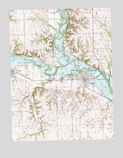
Blue Rapids, KS USGS Topographic Map
Click on map above to begin viewing in our Map Viewer.

This topographic map contains these locations and features:
Feature Name Type Latitude Longitude GNIS ID View Map
Alcove SpringSpringN39.7489°W96.6770°473166View Map
Alcove Springs ParkParkN39.7492°W96.6759°480248View Map
Beattie Farmers Union Co - Operative Association Grain Elevator Number 2LocaleN39.6752°W96.6600°2695116View Map
Beattie Farmers Union Co - Operative Association Grain Elevator Number 5LocaleN39.6913°W96.7489°2695119View Map
BestwallPopulated PlaceN39.7111°W96.6475°484949View Map
Blue RapidsPopulated PlaceN39.6819°W96.6597°473162View Map
Blue Rapids Fire District 7BuildingN39.6833°W96.6596°2111137View Map
Blue Rapids Police DepartmentBuildingN39.6824°W96.6590°2504089View Map
Blue Rapids Post OfficePost OfficeN39.6815°W96.6585°2693634View Map
Blue Rapids Sewer Treatment PlantLocaleN39.6766°W96.6463°2692032View Map
Blue Rapids United Methodist ChurchChurchN39.6846°W96.6604°2689357View Map
City of Blue RapidsCivilN39.6791°W96.6593°2394205View Map
City of WatervilleCivilN39.6920°W96.7473°2397214View Map
Elm CreekStreamN39.6747°W96.6283°472928View Map
Fairmont CemeteryCemeteryN39.6860°W96.6533°473164View Map
Fawn CreekStreamN39.6867°W96.7025°473170View Map
First Baptist ChurchChurchN39.6802°W96.6581°2690726View Map
Greenwood CemeteryCemeteryN39.6517°W96.6699°473169View Map
Idlewild LakeReservoirN39.7091°W96.7446°479950View Map
Independence CrossingLocaleN39.7497°W96.6878°482653View Map
Little Blue RiverStreamN39.6978°W96.6778°473167View Map
Marshall County FairgroundsLocaleN39.6848°W96.6656°2692837View Map
Prospect Hill CemeteryCemeteryN39.7052°W96.6677°473165View Map
Riverside ParkParkN39.6847°W96.6664°473163View Map
Saint Mark Lutheran ChurchChurchN39.6939°W96.7497°2689884View Map
Saint Mark's Lutheran ChurchChurchN39.6815°W96.6575°2690801View Map
Saint Monica - Saint Elizabeth Catholic ChurchChurchN39.6772°W96.6552°2690805View Map
Sedivy Landing Strip (historical)AirportN39.6333°W96.6692°473168View Map
Township of Blue Rapids CityCivilN39.6968°W96.6380°473171View Map
United Presbyterian ChurchChurchN39.6807°W96.6616°2690596View Map
Valley Heights Elementary School - Blue RapidsSchoolN39.6821°W96.6558°2497558View Map
Valley Heights Elementary School - WatervilleSchoolN39.6885°W96.7453°480247View Map
Valley Heights Junior / Senior High SchoolSchoolN39.6865°W96.7115°2497357View Map
Valley Heights Kinder - Prep / PreschoolSchoolN39.6885°W96.7451°2497632View Map
WatervillePopulated PlaceN39.6911°W96.7475°473159View Map
Waterville Ambulance ServiceBuildingN39.6911°W96.7430°2696449View Map
Waterville DamDamN39.7083°W96.7453°479951View Map
Waterville Fire Department / District 6BuildingN39.6922°W96.7471°2111970View Map
Waterville Golf CourseLocaleN39.6883°W96.7297°485386View Map
Waterville Police DepartmentBuildingN39.6928°W96.7488°2504032View Map
Waterville Post OfficePost OfficeN39.6924°W96.7496°2694011View Map
Waterville Public LibraryBuildingN39.6928°W96.7487°2694683View Map
Waterville United Methodist ChurchChurchN39.6896°W96.7491°2689566View Map
Waterville Wastewater Treatment FacilityLocaleN39.6954°W96.7306°2691962View Map

Note: Coordinates in the location and feature list above are referenced to NAD83 datum.


Copyright (C) 2008-2025 Ryan Niemi / Sunset Dynamics ... All Rights Reserved