TopoQuest Logo
Do you find TopoQuest useful?
Help keep TopoQuest running and adding new maps/features by donating!
Bitcoin:  19c7KJd3qBynnjoSw5npx9KScwjBe4ifkT
Litecoin:  LXs6TkuXGGXo1vDsWCkWVdjQX94eUKd6ui
Home View Maps Find Maps Find Places Resources & Links


Tracy, Missouri Topographic Map

USGS Map Title: Tracy, MO
USGS Map MRC: 39094D7
DRG (GeoTIFF) Download: o39094d7.tif


Neighboring USGS Topographic Map Quads:


  De Kalb, MO  
39094E8
 

  Dearborn, MO  
39094E7
 

  Edgerton, MO  
39094E6
 

  Weston, MO  
39094D8
 

  Tracy, MO  
39094D7
 

  Camden Point, MO  
39094D6
 

  Leavenworth, KS  
39094C8
 

  Platte City, MO  
39094C7
 

  Ferrelview, MO  
39094C6


Map MRC Location:

N40°
W95°
N40°
W94°
H8 H7 H6 H5 H4 H3 H2 H1
G8 G7 G6 G5 G4 G3 G2 G1
F8 F7 F6 F5 F4 F3 F2 F1
E8 E7 E6 E5 E4 E3 E2 E1
D8 D7 D6 D5 D4 D3 D2 D1
C8 C7 C6 C5 C4 C3 C2 C1
B8 B7 B6 B5 B4 B3 B2 B1
A8 A7 A6 A5 A4 A3 A2 A1
N39°
W95°
N39°
W94°

Tracy, MO USGS 1:24K Topographic Map Preview:
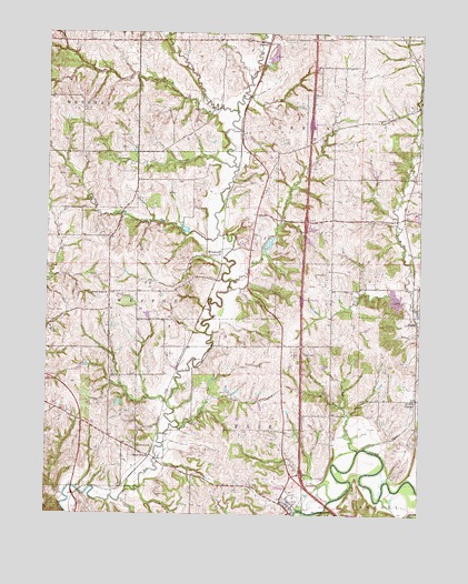
Tracy, MO USGS Topographic Map
Click on map above to begin viewing in our Map Viewer.

This topographic map contains these locations and features:
Feature Name Type Latitude Longitude GNIS ID View Map
Bonnell BranchStreamN39.4656°W94.8127°714524View Map
City of TracyCivilN39.3756°W94.7918°2397045View Map
DuncanLocaleN39.4814°W94.7513°734176View Map
Elm Grove SchoolSchoolN39.4758°W94.7788°734177View Map
Flintlock Church (historical)ChurchN39.4336°W94.8080°734179View Map
Flintlock FieldAirportN39.4324°W94.8039°2717223View Map
Flintlock Field AirportAirportN39.4324°W94.8039°758862View Map
Folck LakeReservoirN39.4433°W94.8019°761936View Map
Folck Lake DamDamN39.4433°W94.8019°761935View Map
Fulton CemeteryCemeteryN39.4169°W94.7891°718293View Map
Hardesty BranchStreamN39.4475°W94.8180°719083View Map
HayditePopulated PlaceN39.4975°W94.8019°740916View Map
Hazelwood SchoolSchoolN39.3961°W94.8550°734173View Map
Hiatt LakeReservoirN39.4050°W94.8502°761617View Map
Hiatt Lake DamDamN39.4050°W94.8502°761616View Map
Jordan BranchStreamN39.4792°W94.8122°720433View Map
Jowler CreekStreamN39.4256°W94.7502°720442View Map
Kitchen CemeteryCemeteryN39.4275°W94.8705°720657View Map
Little Jordan BranchStreamN39.4808°W94.8205°721259View Map
Louise's StripAirportN39.4235°W94.8369°2679404View Map
Murray BranchStreamN39.3917°W94.7702°723080View Map
North Platte Airpark (historical)AirportN39.4664°W94.7616°758616View Map
North Platte Elementary SchoolSchoolN39.4534°W94.7515°2545229View Map
Owl CreekStreamN39.4356°W94.8139°723918View Map
Platte City CemeteryCemeteryN39.3751°W94.7816°2702660View Map
Platte CountyCivilN39.3805°W94.7736°758537View Map
Pleasant Ridge Baptist ChurchChurchN39.4322°W94.8547°724589View Map
Pleasant Ridge CemeteryCemeteryN39.4311°W94.8549°2702661View Map
Pleasant Ridge SchoolSchoolN39.4331°W94.8547°746570View Map
Quinn SchoolSchoolN39.4122°W94.7980°734180View Map
Rogers LakeReservoirN39.4137°W94.7822°761572View Map
Rogers Lake DamDamN39.4133°W94.7819°761571View Map
Schaback StripAirportN39.4250°W94.8488°758991View Map
Settles StationLocaleN39.4050°W94.7511°726211View Map
Singleton BranchStreamN39.4839°W94.8080°734175View Map
StubbsPopulated PlaceN39.4250°W94.7511°741300View Map
Swamp SchoolSchoolN39.4614°W94.8450°736383View Map
Township of FairCivilN39.3950°W94.7964°767197View Map
TracyPopulated PlaceN39.3769°W94.7930°727752View Map
Tracy Police DepartmentBuildingN39.3774°W94.7924°2752588View Map
Triple R AirportAirportN39.4875°W94.7821°2679319View Map
West PlattePopulated PlaceN39.3903°W94.8400°741349View Map
Wilkerson CemeteryCemeteryN39.3925°W94.8455°728862View Map
Woodland School (historical)SchoolN39.4144°W94.7994°734178View Map
WoodruffPopulated PlaceN39.4439°W94.8166°741372View Map

Note: Coordinates in the location and feature list above are referenced to NAD83 datum.


Copyright (C) 2008-2025 Ryan Niemi / Sunset Dynamics ... All Rights Reserved