TopoQuest Logo
Do you find TopoQuest useful?
Help keep TopoQuest running and adding new maps/features by donating!
Bitcoin:  19c7KJd3qBynnjoSw5npx9KScwjBe4ifkT
Litecoin:  LXs6TkuXGGXo1vDsWCkWVdjQX94eUKd6ui
Home View Maps Find Maps Find Places Resources & Links


Trailcreek, Montana Topographic Map

USGS Map Title: Trailcreek, MT
USGS Map MRC: 48114H4
DRG (GeoTIFF) Download: o48114h4.tif


Neighboring USGS Topographic Map Quads:


  Mount Hefty, MT  
48114H5
 

  Trailcreek, MT  
48114H4
 

  Kintla Lake, MT  
48114H3
 

  Red Meadow Lake, MT  
48114G5
 

  Whale Buttes, MT  
48114G4
 

  Polebridge, MT  
48114G3


Map MRC Location:

N49°
W115°
N49°
W114°
H8 H7 H6 H5 H4 H3 H2 H1
G8 G7 G6 G5 G4 G3 G2 G1
F8 F7 F6 F5 F4 F3 F2 F1
E8 E7 E6 E5 E4 E3 E2 E1
D8 D7 D6 D5 D4 D3 D2 D1
C8 C7 C6 C5 C4 C3 C2 C1
B8 B7 B6 B5 B4 B3 B2 B1
A8 A7 A6 A5 A4 A3 A2 A1
N48°
W115°
N48°
W114°

Trailcreek, MT USGS 1:24K Topographic Map Preview:
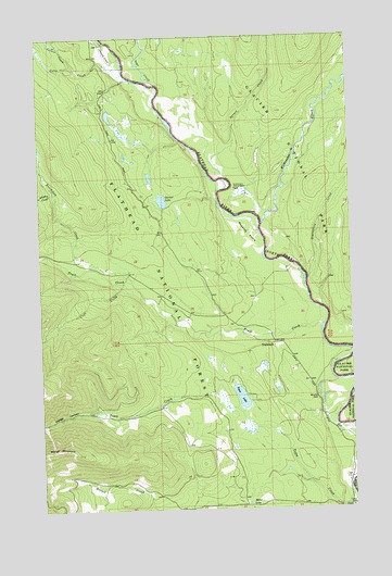
Trailcreek, MT USGS Topographic Map
Click on map above to begin viewing in our Map Viewer.

This topographic map contains these locations and features:
Feature Name Type Latitude Longitude GNIS ID View Map
Abbotts FlatsFlatN48.9486°W114.4165°778857View Map
Calder CreekStreamN48.9929°W114.4866°780775View Map
Cleft CreekStreamN48.9347°W114.4676°781369View Map
Colts CreekStreamN48.9911°W114.4665°781522View Map
FordPopulated PlaceN48.8755°W114.3782°800801View Map
Ford Ranger StationBuildingN48.8758°W114.3765°793955View Map
Garnet LakeLakeN48.9568°W114.4514°783838View Map
Johnson CreekStreamN48.9591°W114.4940°785527View Map
Ketchikan CreekStreamN48.9383°W114.4654°785698View Map
Kintla WellWellN48.8980°W114.3754°785764View Map
Kishenehn CreekStreamN48.9503°W114.4118°785774View Map
Kishenehn Patrol CabinLocaleN48.9600°W114.4224°785775View Map
Miller LakeLakeN48.8765°W114.4181°787424View Map
Moose CityLocaleN48.9991°W114.4732°1795984View Map
Moose City AirportAirportN48.9967°W114.4741°2717684View Map
Port of Trail Trail Creek StationLocaleN48.9997°W114.4788°1796257View Map
Sage CreekStreamN48.9872°W114.4526°789905View Map
Spruce CreekStreamN48.9625°W114.4251°791337View Map
Starvation CreekStreamN48.9355°W114.3938°791457View Map
Tepee LakeLakeN48.9048°W114.4210°791990View Map
Trail CreekStreamN48.9230°W114.3882°792318View Map
TrailcreekPopulated PlaceN48.9191°W114.4074°792327View Map
Trailcreek Post Office (historical)Post OfficeN48.9191°W114.4074°1796156View Map
Wedge CanyonValleyN48.9005°W114.4783°792914View Map
Wedge MountainSummitN48.8906°W114.4996°792916View Map
Wurtz Airport (historical)AirportN48.9047°W114.3824°806454View Map
Wurtz HillPopulated PlaceN48.9039°W114.3904°793562View Map

Note: Coordinates in the location and feature list above are referenced to NAD83 datum.


Copyright (C) 2008-2024 Ryan Niemi / Sunset Dynamics ... All Rights Reserved