TopoQuest Logo
Do you find TopoQuest useful?
Help keep TopoQuest running and adding new maps/features by donating!
Bitcoin:  19c7KJd3qBynnjoSw5npx9KScwjBe4ifkT
Litecoin:  LXs6TkuXGGXo1vDsWCkWVdjQX94eUKd6ui
Home View Maps Find Maps Find Places Resources & Links


Trappers Lake, Colorado Topographic Map

USGS Map Title: Trappers Lake, CO
USGS Map MRC: 39107H2
DRG (GeoTIFF) Download: o39107h2.tif


Neighboring USGS Topographic Map Quads:


  Ripple Creek, CO  
40107A3
 

  Devils Causeway, CO  
40107A2
 

  Orno Peak, CO  
40107A1
 

  Big Marvine Peak, CO  
39107H3
 

  Trappers Lake, CO  
39107H2
 

  Dome Peak, CO  
39107H1
 

  Deep Lake, CO  
39107G3
 

  Sweetwater Lake, CO  
39107G2
 

  Sugarloaf Mountain, CO  
39107G1


Map MRC Location:

N40°
W108°
N40°
W107°
H8 H7 H6 H5 H4 H3 H2 H1
G8 G7 G6 G5 G4 G3 G2 G1
F8 F7 F6 F5 F4 F3 F2 F1
E8 E7 E6 E5 E4 E3 E2 E1
D8 D7 D6 D5 D4 D3 D2 D1
C8 C7 C6 C5 C4 C3 C2 C1
B8 B7 B6 B5 B4 B3 B2 B1
A8 A7 A6 A5 A4 A3 A2 A1
N39°
W108°
N39°
W107°

Trappers Lake, CO USGS 1:24K Topographic Map Preview:
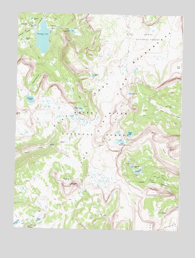
Trappers Lake, CO USGS Topographic Map
Click on map above to begin viewing in our Map Viewer.

This topographic map contains these locations and features:
Feature Name Type Latitude Longitude GNIS ID View Map
AmphitheatreBasinN39.9625°W107.2367°173688View Map
Anderson LakeLakeN39.9848°W107.2448°173668View Map
Bucks CampgroundLocaleN39.9941°W107.2398°196671View Map
Bull LakeLakeN39.8857°W107.1394°173677View Map
Coffin LakeLakeN39.9924°W107.2207°173667View Map
Crescent LakeLakeN39.9961°W107.2412°173669View Map
Crescent LakeLakeN39.9093°W107.1564°173682View Map
Crescent Lake Number 1ReservoirN39.9083°W107.1639°199847View Map
Crescent Lake Number 1 DamDamN39.9083°W107.1639°199846View Map
Crescent Lake Number 2ReservoirN39.9067°W107.1556°199849View Map
Crescent Lake Number 2 DamDamN39.9067°W107.1556°199848View Map
Cutthroat CampgroundLocaleN39.9930°W107.2420°197605View Map
Deer LakeLakeN39.9544°W107.1643°173687View Map
Derby PeakSummitN39.9736°W107.1253°202175View Map
Fraser CreekStreamN39.9733°W107.2298°173665View Map
Island LakeLakeN39.9264°W107.1714°173685View Map
Little Marvine PeaksSummitN39.9889°W107.1551°202174View Map
Little Trappers LakeLakeN39.9898°W107.2087°173666View Map
Mackinaw LakeLakeN39.9118°W107.1613°173683View Map
Mirror LakeLakeN39.9472°W107.1319°173686View Map
Parvin LakeLakeN39.9452°W107.2012°173664View Map
Rim LakeLakeN39.8802°W107.2314°173681View Map
Scotts Bay TrailheadLocaleN39.9908°W107.2414°197603View Map
Scotts LakeLakeN39.9926°W107.2370°173670View Map
Scotts Lake TrailheadLocaleN39.9950°W107.2373°196670View Map
Sheep MountainSummitN39.9225°W107.1331°202176View Map
Shepherd LakeLakeN39.8777°W107.2477°173662View Map
Shepherds Rim CampgroundLocaleN39.9953°W107.2431°197606View Map
Shingle LakeLakeN39.9040°W107.2094°173673View Map
Shingle PeakSummitN39.9014°W107.2067°173674View Map
Surprise LakeLakeN39.9645°W107.1927°173680View Map
Trapline CampgroundLocaleN39.9939°W107.2409°196672View Map
Trappers LakeLakeN39.9857°W107.2311°173679View Map
Trappers Lake CampgroundLocaleN39.9939°W107.2417°173671View Map
Trappers Outlet TrailheadLocaleN39.9989°W107.2303°196675View Map
Upper Island LakeLakeN39.9264°W107.1695°173684View Map
Wall LakeLakeN39.9499°W107.2396°173689View Map
Wall Lake TrailheadLocaleN39.9905°W107.2439°197604View Map

Note: Coordinates in the location and feature list above are referenced to NAD83 datum.


Copyright (C) 2008-2024 Ryan Niemi / Sunset Dynamics ... All Rights Reserved