TopoQuest Logo
Do you find TopoQuest useful?
Help keep TopoQuest running and adding new maps/features by donating!
Bitcoin:  19c7KJd3qBynnjoSw5npx9KScwjBe4ifkT
Litecoin:  LXs6TkuXGGXo1vDsWCkWVdjQX94eUKd6ui
Home View Maps Find Maps Find Places Resources & Links


Trinity, Georgia Topographic Map

USGS Map Title: Trinity, GA
USGS Map MRC: 31081H5
DRG (GeoTIFF) Download: o31081h5.tif


Neighboring USGS Topographic Map Quads:


  Willie, GA  
32081A6
 

  Letford, GA  
32081A5
 

  Meldrim SW, GA  
32081A4
 

  Taylors Creek, GA  
31081H6
 

  Trinity, GA  
31081H5
 

  Limerick NW, GA  
31081H4
 

  Walthourville, GA  
31081G6
 

  Hinesville, GA  
31081G5
 

  Dorchester, GA  
31081G4


Map MRC Location:

N32°
W82°
N32°
W81°
H8 H7 H6 H5 H4 H3 H2 H1
G8 G7 G6 G5 G4 G3 G2 G1
F8 F7 F6 F5 F4 F3 F2 F1
E8 E7 E6 E5 E4 E3 E2 E1
D8 D7 D6 D5 D4 D3 D2 D1
C8 C7 C6 C5 C4 C3 C2 C1
B8 B7 B6 B5 B4 B3 B2 B1
A8 A7 A6 A5 A4 A3 A2 A1
N31°
W82°
N31°
W81°

Trinity, GA USGS 1:24K Topographic Map Preview:
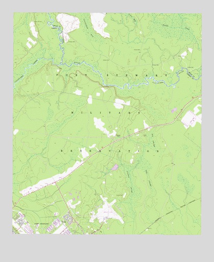
Trinity, GA USGS Topographic Map
Click on map above to begin viewing in our Map Viewer.

This topographic map contains these locations and features:
Feature Name Type Latitude Longitude GNIS ID View Map
Big SwampSwampN31.8923°W81.5398°311420View Map
Brittin Elementary SchoolSchoolN31.8912°W81.5970°2453119View Map
Bryan VillagePopulated PlaceN31.8919°W81.5929°357054View Map
Butlers Bridge (historical)BridgeN31.9927°W81.5990°350503View Map
Canoochee CreekStreamN31.9710°W81.5923°354986View Map
Chapel in the ValeChurchN31.8938°W81.5968°357057View Map
Diamond Elementary SchoolSchoolN31.8821°W81.6148°2453133View Map
Fort StewartMilitaryN31.9827°W81.5970°2512222View Map
Goshen SwampSwampN31.9052°W81.5471°314731View Map
Hallwood HomesPopulated PlaceN31.8772°W81.6132°357084View Map
Hinesville - Fort Stewart Water Pollution Control PlantLocaleN31.8818°W81.6087°2502457View Map
Hinesville DivisionCivilN31.9171°W81.6234°1936318View Map
Mellwood School (historical)SchoolN31.9547°W81.5901°357104View Map
Riverside School (historical)SchoolN31.9699°W81.5479°350532View Map
Stewart HomesLocaleN31.8822°W81.5887°323605View Map
Taylors Creek Golf CourseLocaleN31.8780°W81.6207°2502678View Map
Thomas Hill CemeteryCemeteryN31.9952°W81.6115°324084View Map
Thomas Hill School (historical)SchoolN31.9946°W81.6115°357135View Map
TrinityPopulated PlaceN31.9299°W81.5565°333264View Map
Trinity CemeteryCemeteryN31.9310°W81.5382°324296View Map
Wright Army Airfield (Fort Stewart)/Midcoast Regional AirportAirportN31.8844°W81.5617°2646214View Map

Note: Coordinates in the location and feature list above are referenced to NAD83 datum.


Copyright (C) 2008-2024 Ryan Niemi / Sunset Dynamics ... All Rights Reserved