TopoQuest Logo
Do you find TopoQuest useful?
Help keep TopoQuest running and adding new maps/features by donating!
Bitcoin:  19c7KJd3qBynnjoSw5npx9KScwjBe4ifkT
Litecoin:  LXs6TkuXGGXo1vDsWCkWVdjQX94eUKd6ui
Home View Maps Find Maps Find Places Resources & Links


Troy, Montana Topographic Map

USGS Map Title: Troy, MT
USGS Map MRC: 48115D8
DRG (GeoTIFF) Download: o48115d8.tif


Neighboring USGS Topographic Map Quads:


  Leonia, ID  
48116E1
 

  Kilbrennan Lake, MT  
48115E8
 

  Pulpit Mountain, MT  
48115E7
 

  Smith Mountain, ID  
48116D1
 

  Troy, MT  
48115D8
 

  Kootenai Falls, MT  
48115D7
 

  Benning Mountain, ID  
48116C1
 

  Spar Lake, MT  
48115C8
 

  Crowell Mountain, MT  
48115C7


Map MRC Location:

N49°
W116°
N49°
W115°
H8 H7 H6 H5 H4 H3 H2 H1
G8 G7 G6 G5 G4 G3 G2 G1
F8 F7 F6 F5 F4 F3 F2 F1
E8 E7 E6 E5 E4 E3 E2 E1
D8 D7 D6 D5 D4 D3 D2 D1
C8 C7 C6 C5 C4 C3 C2 C1
B8 B7 B6 B5 B4 B3 B2 B1
A8 A7 A6 A5 A4 A3 A2 A1
N48°
W116°
N48°
W115°

Troy, MT USGS 1:24K Topographic Map Preview:
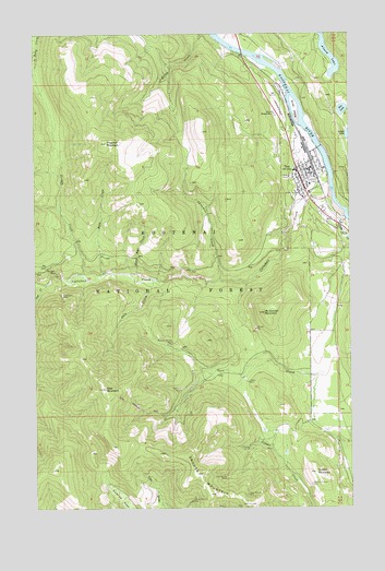
Troy, MT USGS Topographic Map
Click on map above to begin viewing in our Map Viewer.

This topographic map contains these locations and features:
Feature Name Type Latitude Longitude GNIS ID View Map
31N33W18CCAA01 WellWellN48.4458°W115.8768°1635563View Map
31N34W01CCCD01 WellWellN48.4724°W115.9007°1635638View Map
31N34W13BCAA01 WellWellN48.4536°W115.8991°1635586View Map
31N34W36ABDC01 WellWellN48.4105°W115.8879°1635379View Map
32N34W35DCCD01 WellWellN48.4872°W115.9113°1635704View Map
Alvord LakeLakeN48.4938°W115.8833°1782346View Map
Assembly of God ChurchChurchN48.4633°W115.8896°1782293View Map
Big Eight MineMineN48.4361°W115.9905°804047View Map
Big Eight MineMineN48.4374°W115.9924°779803View Map
Black Bear CreekStreamN48.4369°W115.9605°779963View Map
Callahan CreekStreamN48.4574°W115.8827°780790View Map
City of TroyCivilN48.4623°W115.8917°2412101View Map
Copper MountainSummitN48.3844°W115.8899°781658View Map
Crescent MineMineN48.3911°W115.9166°804115View Map
Crescent TunnelMineN48.3911°W115.9166°781887View Map
Faith Christian ChurchChurchN48.4633°W115.8896°1782292View Map
First Christian Church of TroyChurchN48.4633°W115.8896°1782295View Map
Giant Sunrise MineMineN48.3830°W115.9254°783917View Map
Goat CreekStreamN48.4341°W115.9963°784007View Map
Goat MountainSummitN48.4066°W115.9738°784022View Map
Goat Mountain TrailTrailN48.4027°W115.9641°1782394View Map
Gordon CreekStreamN48.4366°W115.9818°784119View Map
Grouse MountainSummitN48.3838°W115.9374°784389View Map
Grouse Mountain (historical)LocaleN48.3763°W115.9260°1782416View Map
Grouse Mountain MineMineN48.3770°W115.9392°784390View Map
Grouse Mountain Number 3 MineMineN48.3772°W115.9213°804083View Map
Grouse Mountain Number 4 MineMineN48.3752°W115.9213°804084View Map
Grouse Mountain Number 6 MineMineN48.3755°W115.9271°804099View Map
Grouse Mountain Number 7 MineMineN48.3791°W115.9177°804081View Map
Hale CreekStreamN48.4369°W115.9738°784457View Map
Hale Creek MineMineN48.4541°W115.9746°804075View Map
Immaculate Conception MissionChurchN48.4633°W115.8896°1782289View Map
July CreekStreamN48.4349°W115.9541°785590View Map
Kootenai River CampgroundLocaleN48.4930°W115.9177°1782384View Map
La-Vi RV ParkLocaleN48.4541°W115.8899°1782383View Map
Lake CreekStreamN48.4513°W115.8779°785910View Map
Lake Creek DamDamN48.4383°W115.8760°795202View Map
Liberty MineMineN48.4082°W115.9168°786093View Map
Lower Hale MineMineN48.4527°W115.9741°804088View Map
McConnell MountainSummitN48.4263°W115.9099°787011View Map
Medicine Tree Primary CareHospitalN48.4574°W115.8949°1782300View Map
Montana Morning MineMineN48.4188°W115.9466°787571View Map
Montana Premier MineMineN48.3811°W115.8918°787572View Map
Moose LakeLakeN48.4734°W115.8762°786674View Map
Preacher MountainSummitN48.4713°W115.9721°789180View Map
Scott IslandIslandN48.4799°W115.8974°790157View Map
Silver Grouse MineMineN48.3786°W115.9174°790516View Map
Slee LakeLakeN48.4798°W115.8784°790645View Map
Snowstorm MineMineN48.4313°W115.9905°790809View Map
The Church of Jesus Christ of Latter Day SaintsChurchN48.4633°W115.8896°1782290View Map
Three Lakes Community Bible ChurchChurchN48.4633°W115.8896°1782291View Map
Threemile CreekStreamN48.4352°W115.9277°792134View Map
TroyPopulated PlaceN48.4633°W115.8896°792409View Map
TroyLocaleN48.4641°W115.8899°1782423View Map
Troy AirportAirportN48.4788°W115.9035°806541View Map
Troy Branch LibraryBuildingN48.4624°W115.8927°1782391View Map
Troy BridgeBridgeN48.4699°W115.8871°1782347View Map
Troy CemeteryCemeteryN48.4749°W115.8988°1782297View Map
Troy City ParkParkN48.4602°W115.8899°1782357View Map
Troy Community Baptist ChurchChurchN48.4633°W115.8896°1782294View Map
Troy High SchoolSchoolN48.4636°W115.8966°1782233View Map
Troy Museum and Visitor CenterBuildingN48.4572°W115.8913°1782358View Map
Troy Police DepartmentBuildingN48.4630°W115.8908°1782231View Map
Troy Post OfficePost OfficeN48.4649°W115.8918°1782315View Map
Troy Ranger StationLocaleN48.4791°W115.9057°792414View Map
Troy United Methodist ChurchChurchN48.4633°W115.8896°1782296View Map
Troy Volunteer Ambulance ServiceBuildingN48.4627°W115.8932°2637914View Map
Troy Volunteer Fire DepartmentBuildingN48.4630°W115.8901°1782232View Map
W F Morrison Elementary SchoolSchoolN48.4602°W115.8913°1782234View Map

Note: Coordinates in the location and feature list above are referenced to NAD83 datum.


Copyright (C) 2008-2025 Ryan Niemi / Sunset Dynamics ... All Rights Reserved