TopoQuest Logo
Do you find TopoQuest useful?
Help keep TopoQuest running and adding new maps/features by donating!
Bitcoin:  19c7KJd3qBynnjoSw5npx9KScwjBe4ifkT
Litecoin:  LXs6TkuXGGXo1vDsWCkWVdjQX94eUKd6ui
Home View Maps Find Maps Find Places Resources & Links


Truhart, Virginia Topographic Map

USGS Map Title: Truhart, VA
USGS Map MRC: 37076F7
DRG (GeoTIFF) Download: o37076f7.tif


Neighboring USGS Topographic Map Quads:


  Millers Tavern, VA  
37076G8
 

  Dunnsville, VA  
37076G7
 

  Morattico, VA  
37076G6
 

  King And Queen Court House, VA  
37076F8
 

  Truhart, VA  
37076F7
 

  Church View, VA  
37076F6
 

  New Kent, VA  
37076E8
 

  West Point, VA  
37076E7
 

  Shacklefords, VA  
37076E6


Map MRC Location:

N38°
W77°
N38°
W76°
H8 H7 H6 H5 H4 H3 H2 H1
G8 G7 G6 G5 G4 G3 G2 G1
F8 F7 F6 F5 F4 F3 F2 F1
E8 E7 E6 E5 E4 E3 E2 E1
D8 D7 D6 D5 D4 D3 D2 D1
C8 C7 C6 C5 C4 C3 C2 C1
B8 B7 B6 B5 B4 B3 B2 B1
A8 A7 A6 A5 A4 A3 A2 A1
N37°
W77°
N37°
W76°

Truhart, VA USGS 1:24K Topographic Map Preview:
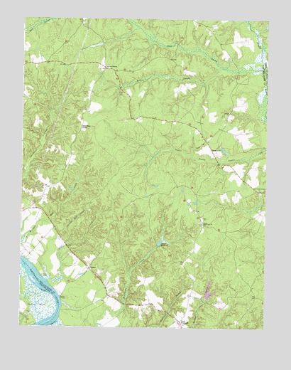
Truhart, VA USGS Topographic Map
Click on map above to begin viewing in our Map Viewer.

This topographic map contains these locations and features:
Feature Name Type Latitude Longitude GNIS ID View Map
Allen Shop CornerPopulated PlaceN37.7057°W76.8447°1499048View Map
Allens Mill DamDamN37.6582°W76.8047°1490167View Map
Allens MillpondReservoirN37.6593°W76.8038°1501940View Map
Carlton CornerPopulated PlaceN37.7301°W76.8327°1477177View Map
Carlton Hill SwampStreamN37.6588°W76.8494°1464445View Map
Central King and Queen Volunteer Fire DepartmentBuildingN37.6709°W76.8749°2086193View Map
Davis BeachBeachN37.6449°W76.8633°1465633View Map
DragonvillePopulated PlaceN37.6974°W76.7780°1499355View Map
Exol CemeteryCemeteryN37.7493°W76.8455°1466379View Map
Exol SwampStreamN37.7293°W76.7511°1466380View Map
Grass CreekStreamN37.6438°W76.8616°1467357View Map
Holmes SwampStreamN37.7304°W76.7719°1468173View Map
King and Queen LandfillLocaleN37.6679°W76.7756°2519487View Map
Little PlymouthPopulated PlaceN37.6274°W76.7927°1469618View Map
Lower King and Queen ChurchChurchN37.6807°W76.7536°1469913View Map
Melrose LandingLocaleN37.6374°W76.8550°1499730View Map
Nell BranchStreamN37.6943°W76.7872°1471376View Map
Normans DamDamN37.6385°W76.7797°1490185View Map
Second Mount Olive ChurchChurchN37.6671°W76.7822°1474147View Map
Stevensville DistrictCivilN37.7117°W76.8544°1927520View Map
Townsend DamDamN37.6951°W76.7697°1490176View Map
TruhartPopulated PlaceN37.6488°W76.8397°1477823View Map

Note: Coordinates in the location and feature list above are referenced to NAD83 datum.


Copyright (C) 2008-2024 Ryan Niemi / Sunset Dynamics ... All Rights Reserved