TopoQuest Logo
Do you find TopoQuest useful?
Help keep TopoQuest running and adding new maps/features by donating!
Bitcoin:  19c7KJd3qBynnjoSw5npx9KScwjBe4ifkT
Litecoin:  LXs6TkuXGGXo1vDsWCkWVdjQX94eUKd6ui
Home View Maps Find Maps Find Places Resources & Links


Twin Knolls, Utah Topographic Map

USGS Map Title: Twin Knolls, UT
USGS Map MRC: 38110G6
DRG (GeoTIFF) Download: o38110g6.tif


Neighboring USGS Topographic Map Quads:


  The Blocks, UT  
38110H7
 

  The Wickiup, UT  
38110H6
 

  Drowned Hole Draw, UT  
38110H5
 

  San Rafael Knob, UT  
38110G7
 

  Twin Knolls, UT  
38110G6
 

  Arsons Garden, UT  
38110G5
 

  Horse Valley, UT  
38110F7
 

  Temple Mountain, UT  
38110F6
 

  Old Woman Wash, UT  
38110F5


Map MRC Location:

N39°
W111°
N39°
W110°
H8 H7 H6 H5 H4 H3 H2 H1
G8 G7 G6 G5 G4 G3 G2 G1
F8 F7 F6 F5 F4 F3 F2 F1
E8 E7 E6 E5 E4 E3 E2 E1
D8 D7 D6 D5 D4 D3 D2 D1
C8 C7 C6 C5 C4 C3 C2 C1
B8 B7 B6 B5 B4 B3 B2 B1
A8 A7 A6 A5 A4 A3 A2 A1
N38°
W111°
N38°
W110°

Twin Knolls, UT USGS 1:24K Topographic Map Preview:
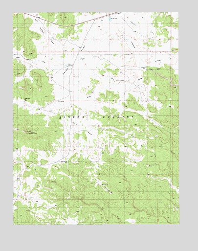
Twin Knolls, UT USGS Topographic Map
Click on map above to begin viewing in our Map Viewer.

This topographic map contains these locations and features:
Feature Name Type Latitude Longitude GNIS ID View Map
Block MountainSummitN38.8039°W110.7377°1435162View Map
Charley FlatFlatN38.8491°W110.6365°1426541View Map
Charley HolesSpringN38.8414°W110.6421°1426542View Map
Cottonwood HolesSpringN38.8558°W110.6385°1435352View Map
Crawford HolesSpringN38.8430°W110.6493°1427085View Map
Earls DrawValleyN38.8505°W110.7452°1427655View Map
Georges DrawValleyN38.8341°W110.6688°1428174View Map
Georges Draw WellWellN38.8236°W110.7418°1428175View Map
Home BaseFlatN38.8047°W110.7013°1428788View Map
Indian FlatFlatN38.8686°W110.6529°1428999View Map
Lone Man ButteSummitN38.7845°W110.6491°1429859View Map
Lone Parson HoleFlatN38.7836°W110.7054°1429864View Map
Paige FlatFlatN38.8505°W110.7032°1431077View Map
Reid Neilson DrawValleyN38.8416°W110.6493°1431745View Map
Road DrawValleyN38.8439°W110.7104°1431875View Map
San Rafael SwellRangeN38.8236°W110.6774°1432177View Map
Sinbad CountryAreaN38.8205°W110.6943°1432482View Map
State PondReservoirN38.8438°W110.7099°1436429View Map
The Big PondReservoirN38.8711°W110.6774°1433266View Map
Twin KnollsSummitN38.7689°W110.6771°1433733View Map
Woodpile PondReservoirN38.8472°W110.6999°1434460View Map

Note: Coordinates in the location and feature list above are referenced to NAD83 datum.


Copyright (C) 2008-2025 Ryan Niemi / Sunset Dynamics ... All Rights Reserved