TopoQuest Logo
Do you find TopoQuest useful?
Help keep TopoQuest running and adding new maps/features by donating!
Bitcoin:  19c7KJd3qBynnjoSw5npx9KScwjBe4ifkT
Litecoin:  LXs6TkuXGGXo1vDsWCkWVdjQX94eUKd6ui
Home View Maps Find Maps Find Places Resources & Links


Union Center, Illinois Topographic Map

USGS Map Title: Union Center, IL
USGS Map MRC: 39088C1
DRG (GeoTIFF) Download: o39088c1.tif


Neighboring USGS Topographic Map Quads:


  Charleston South, IL  
39088D2
 

  Westfield West, IL  
39088D1
 

  Westfield East, IL  
39087D8
 

  Toledo, IL  
39088C2
 

  Union Center, IL  
39088C1
 

  Casey, IL  
39087C8
 

  Greenup, IL  
39088B2
 

  Hazel Dell, IL  
39088B1
 

  Moriah, IL  
39087B8


Map MRC Location:

N40°
W89°
N40°
W88°
H8 H7 H6 H5 H4 H3 H2 H1
G8 G7 G6 G5 G4 G3 G2 G1
F8 F7 F6 F5 F4 F3 F2 F1
E8 E7 E6 E5 E4 E3 E2 E1
D8 D7 D6 D5 D4 D3 D2 D1
C8 C7 C6 C5 C4 C3 C2 C1
B8 B7 B6 B5 B4 B3 B2 B1
A8 A7 A6 A5 A4 A3 A2 A1
N39°
W89°
N39°
W88°

Union Center, IL USGS 1:24K Topographic Map Preview:
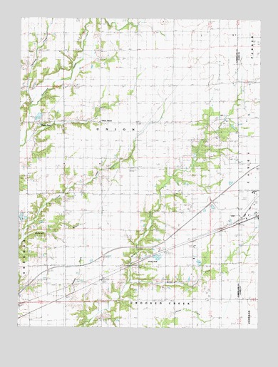
Union Center, IL USGS Topographic Map
Click on map above to begin viewing in our Map Viewer.

This topographic map contains these locations and features:
Feature Name Type Latitude Longitude GNIS ID View Map
Birch CreekStreamN39.2681°W88.0670°404456View Map
Boots CemeteryCemeteryN39.2700°W88.1236°404701View Map
Brushy Ridge School (historical)SchoolN39.2748°W88.1203°405063View Map
Casey Municipal AirportAirportN39.3046°W88.0032°427120View Map
Decker CemeteryCemeteryN39.3273°W88.1150°1922825View Map
Duck Pond CemeteryCemeteryN39.2578°W88.0839°407457View Map
Ettlebrick LakeReservoirN39.2786°W88.0527°1691877View Map
Ettlebrick Lake DamDamN39.2800°W88.0517°1691876View Map
Fairview School (historical)SchoolN39.3342°W88.0645°408211View Map
Garrett CemeteryCemeteryN39.2898°W88.0528°1922828View Map
Lacey School (historical)SchoolN39.3123°W88.0392°411672View Map
Lefever School (historical)SchoolN39.2861°W88.0189°411921View Map
Lincoln Trail Motosports ParkBuildingN39.2737°W88.0714°2673940View Map
Lockwain School (historical)SchoolN39.3625°W88.1203°412476View Map
Long Point CemeteryCemeteryN39.3039°W88.0384°1820735View Map
Long Point Church (historical)ChurchN39.3045°W88.0373°412587View Map
Macedonia Baptist ChurchChurchN39.3323°W88.0281°412795View Map
Macedonia CemeteryCemeteryN39.3317°W88.0284°1820736View Map
Maple PointPopulated PlaceN39.3323°W88.1131°422936View Map
McKnight BranchStreamN39.2859°W88.1217°413317View Map
McMillan School (historical)SchoolN39.3620°W88.0831°413326View Map
Mount Zion ChurchChurchN39.3473°W88.1023°414133View Map
Nebo CemeteryCemeteryN39.3478°W88.1028°1820738View Map
Opossum CreekStreamN39.3395°W88.1195°415146View Map
Pleasant Valley Church (historical)ChurchN39.2750°W88.1003°415906View Map
Plum Grove School (historical)SchoolN39.3036°W88.1189°415954View Map
Reed School (historical)SchoolN39.3053°W88.0814°416487View Map
Ruffner CemeteryCemeteryN39.2748°W88.0689°1922852View Map
Ruffner CreekStreamN39.2531°W88.0884°417031View Map
Ruffner School (historical)SchoolN39.2703°W88.0806°417032View Map
Township of UnionCivilN39.3307°W88.0836°429850View Map
Union CemeteryCemeteryN39.3728°W88.0806°1923010View Map
Union CenterPopulated PlaceN39.3328°W88.0814°420036View Map
Vevay ParkPopulated PlaceN39.2792°W88.0536°423277View Map
Weaver School (historical)SchoolN39.3639°W88.0450°420679View Map
West Side Church of ChristChurchN39.2956°W88.0100°1785525View Map
Yanaway School (historical)SchoolN39.3284°W88.0209°421551View Map

Note: Coordinates in the location and feature list above are referenced to NAD83 datum.


Copyright (C) 2008-2025 Ryan Niemi / Sunset Dynamics ... All Rights Reserved