TopoQuest Logo
Do you find TopoQuest useful?
Help keep TopoQuest running and adding new maps/features by donating!
Bitcoin:  19c7KJd3qBynnjoSw5npx9KScwjBe4ifkT
Litecoin:  LXs6TkuXGGXo1vDsWCkWVdjQX94eUKd6ui
Home View Maps Find Maps Find Places Resources & Links


Union City, Kentucky Topographic Map

USGS Map Title: Union City, KY
USGS Map MRC: 37084G2
DRG (GeoTIFF) Download: o37084g2.tif


Neighboring USGS Topographic Map Quads:


  Ford, KY  
37084H3
 

  Winchester, KY  
37084H2
 

  Hedges, KY  
37084H1
 

  Richmond North, KY  
37084G3
 

  Union City, KY  
37084G2
 

  Palmer, KY  
37084G1
 

  Richmond South, KY  
37084F3
 

  Moberly, KY  
37084F2
 

  Panola, KY  
37084F1


Map MRC Location:

N38°
W85°
N38°
W84°
H8 H7 H6 H5 H4 H3 H2 H1
G8 G7 G6 G5 G4 G3 G2 G1
F8 F7 F6 F5 F4 F3 F2 F1
E8 E7 E6 E5 E4 E3 E2 E1
D8 D7 D6 D5 D4 D3 D2 D1
C8 C7 C6 C5 C4 C3 C2 C1
B8 B7 B6 B5 B4 B3 B2 B1
A8 A7 A6 A5 A4 A3 A2 A1
N37°
W85°
N37°
W84°

Union City, KY USGS 1:24K Topographic Map Preview:
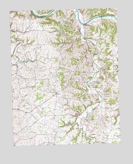
Union City, KY USGS Topographic Map
Click on map above to begin viewing in our Map Viewer.

This topographic map contains these locations and features:
Feature Name Type Latitude Longitude GNIS ID View Map
Baxters Station (historical)LocaleN37.8238°W84.1492°2557621View Map
Bear RunStreamN37.8563°W84.1937°2557657View Map
Brookstown Institute (historical)SchoolN37.8434°W84.2188°2557651View Map
Campbells BranchStreamN37.8160°W84.2437°2557619View Map
Cane Spring HillSummitN37.8288°W84.1422°2557625View Map
Charleston (historical)Populated PlaceN37.8749°W84.2226°2508429View Map
Clear CreekStreamN37.8465°W84.1630°489606View Map
Concord ChurchChurchN37.7523°W84.2049°489933View Map
Coopers RunStreamN37.8289°W84.2412°2557623View Map
DoylesvillePopulated PlaceN37.8442°W84.1608°507873View Map
Doylesville ChurchChurchN37.8484°W84.1644°491082View Map
Doylesville Post Office (historical)Post OfficeN37.8490°W84.1648°2557654View Map
Dunbar BranchStreamN37.8473°W84.1657°491284View Map
Flatwoods Christian ChurchChurchN37.7501°W84.1452°492229View Map
Indian CreekStreamN37.8731°W84.1699°494931View Map
Jackson FerryLocaleN37.8606°W84.1619°495121View Map
Jackson's Ferry (historical)LocaleN37.8698°W84.2132°2508430View Map
Jordan Hill Farm AirportAirportN37.8329°W84.1812°2444060View Map
Mill Dam HillSummitN37.8396°W84.1573°2557649View Map
Muddy CreekStreamN37.8609°W84.1663°514141View Map
Noland Creek CrossroadsLocaleN37.7770°W84.2010°2557595View Map
Oggs Mill (historical)LocaleN37.8406°W84.1516°2557650View Map
Old Cain Springs ChurchChurchN37.8267°W84.1310°499806View Map
Old Cane Springs School (historical)SchoolN37.8271°W84.1308°2558312View Map
Pleasant Green ChurchChurchN37.7545°W84.1405°500802View Map
Rest Haven (historical)LocaleN37.7972°W84.1984°2557608View Map
Rocky LickStreamN37.8454°W84.1755°502257View Map
Turpin BranchStreamN37.7745°W84.1682°2557594View Map
Union CityPopulated PlaceN37.7973°W84.1977°505791View Map
Union City Post Office (historical)Post OfficeN37.7974°W84.1984°2557609View Map
Union City School (historical)SchoolN37.7985°W84.1984°2557612View Map
Union City Volunteer Fire DepartmentBuildingN37.7975°W84.1990°2637091View Map
Upper Howard CreekStreamN37.8651°W84.1252°485707View Map
Webber Sales BranchStreamN37.7576°W84.2058°2557589View Map

Note: Coordinates in the location and feature list above are referenced to NAD83 datum.


Copyright (C) 2008-2025 Ryan Niemi / Sunset Dynamics ... All Rights Reserved